Country:
 Norway
Region:
City:
Latitude and Longitude:
Time Zone:
Postal Code:
IP information under different IP Channel
ip-api
Country
Region
City
ASN
Time Zone
ISP
Blacklist
Proxy
Latitude
Longitude
Postal
Route
IPinfo
Country
Region
City
ASN
Time Zone
ISP
Blacklist
Proxy
Latitude
Longitude
Postal
Route
MaxMind
Country
Region
City
ASN
Time Zone
ISP
Blacklist
Proxy
Latitude
Longitude
Postal
Route
Luminati
Country
NOASN
Time Zone
Europe/Oslo
ISP
Globalconnect As
Latitude
Longitude
Postal
db-ip
Country
Region
City
ASN
Time Zone
ISP
Blacklist
Proxy
Latitude
Longitude
Postal
Route
ipdata
Country
Region
City
ASN
Time Zone
ISP
Blacklist
Proxy
Latitude
Longitude
Postal
Route
Popular places and events near this IP address

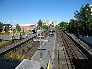
Helsfyr (station)
Oslo metro station
Distance: Approx. 1134 meters
Latitude and longitude: 59.91277778,10.80083333
Helsfyr is a subway station on the east side of the Oslo Metro system located in the borough of Helsfyr. The station is shared by the Furuset Line (Line 2), the Østensjø Line (Line 3) and the Lambertseter Line (Lines 1 and 4). Line 1 terminates at Helsfyr during weekends, late evenings, and vacations.
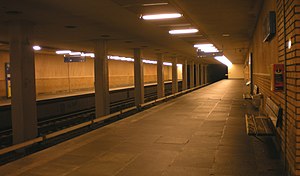
Brynseng (station)
Oslo metro station
Distance: Approx. 541 meters
Latitude and longitude: 59.90916667,10.8125
Brynseng is a rapid transit station on the Oslo Metro system located in the Helsfyr borough. The station is shared by three lines, the Østensjø Line (Line 3), the Furuset Line (Line 2) and the Lambertseter Line (Line 1 and 4). The station has four platforms.
Tveita (station)
Oslo metro station
Distance: Approx. 1147 meters
Latitude and longitude: 59.91361111,10.84111111
Tveita is a subway station on the Furuset Line of the Oslo Metro between Hellerud and Haugerud, located in the Alna borough of Oslo, Norway. The station is the first one on Furusetbanen that is not shared with another line. It was opened as part of the original line in 1970.
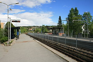
Hellerud (station)
Oslo metro station
Distance: Approx. 554 meters
Latitude and longitude: 59.90972222,10.83027778
Hellerud is a station on the Oslo Metro system which is shared by two lines, line 2 (the Furuset Line) and line 3 (the Østensjø Line). These two lines diverge immediately east of the station with the eastbound Furuset Line track first diverging southwards before running under the Østensjø Line in order to avoid having the main tracks cross each other. The lines share the same track and platforms.

Høyenhall (station)
Oslo metro station
Distance: Approx. 700 meters
Latitude and longitude: 59.90527778,10.81916667
Høyenhall is a rapid transit station on the Lambertseter Line of the Oslo Metro. Served by Line 4, it is the first station on the Lambertseter Line not shared with any other line. It is located between Brynseng and Manglerud, 5.2 kilometres (3.2 mi) away from Stortinget.

Godlia (station)
Oslo metro station
Distance: Approx. 884 meters
Latitude and longitude: 59.90805556,10.83527778
Godlia () is a station on the Østensjø Line (Line 3) on the Oslo Metro. It is the first station after the line diverges from the Furuset Line and is located between the stations of Hellerud and Skøyenåsen, 6.1 kilometers (3.8 mi) from Stortinget. The station was opened as a subway station 29 October 1967.

Bryn Station
Railway station in Oslo, Norway
Distance: Approx. 372 meters
Latitude and longitude: 59.90833333,10.81888889
Bryn Station (Norwegian: Bryn stasjon) is a railway station on the Trunk Line located in the Bryn neighborhood of the Gamle Oslo borough of Oslo, Norway. Situated 3.89 kilometers (2.42 mi) from Oslo Central Station, it features two platforms. The Loenga–Alnabru Line passes through the station without a platform.

Etterstad
Neighborhood in Oslo, Norway
Distance: Approx. 1153 meters
Latitude and longitude: 59.91,10.80055556
Etterstad () is a neighborhood in Oslo, located between the river Alna and Strømsveien, north of Vålerenga. It was incorporated into Oslo in 1946, two years before the merger of Oslo and Aker. The area is mainly residential.

Bryn, Oslo
Distance: Approx. 379 meters
Latitude and longitude: 59.9101,10.8148
Bryn () is a residential and industrial area of Oslo, Norway. The Alna River runs through the neighborhood.

Teisen
Distance: Approx. 463 meters
Latitude and longitude: 59.91532222,10.81773611
Teisen is a neighborhood in the borough of Alna in Oslo, Norway. It was a residential area in the 19th century, but from the 1950s it was built up with apartment blocks.

Valle-Hovin
Distance: Approx. 1102 meters
Latitude and longitude: 59.918,10.8061
Valle-Hovin is a neighborhood in Oslo, Norway, best known for the sports and music venue of the same name. It consists of two neighborhoods with unclear boundaries, Valle and Hovin. Valle was a farm under Nonneseter but was bought by private owners in 1765; the farm Hovin was probably under Torshov, then under Oslo Cathedral before the Reformation.

Intility Arena
Football stadium in Oslo, Norway
Distance: Approx. 1051 meters
Latitude and longitude: 59.91777778,10.80694444
Intility Arena, also referred to as Vålerenga Stadion, is an association football stadium in Oslo, Norway. The stadium is the home stadium for Vålerenga Fotball, currently playing in the Norwegian First Division, and Vålerenga Fotball Damer, currently playing in the Toppserien. It has a seating capacity of 16,555 people.
Weather in this IP's area
overcast clouds
11 Celsius
10 Celsius
10 Celsius
12 Celsius
1017 hPa
98 %
1017 hPa
1005 hPa
8239 meters
1.06 m/s
3.96 m/s
136 degree
100 %
08:06:12
17:56:43