Country:
Region:
City:
Latitude and Longitude:
Time Zone:
Postal Code:
IP information under different IP Channel
ip-api
Country
Region
City
ASN
Time Zone
ISP
Blacklist
Proxy
Latitude
Longitude
Postal
Route
Luminati
Country
ASN
Time Zone
Europe/Isle_of_Man
ISP
CL-1379-14537
Latitude
Longitude
Postal
IPinfo
Country
Region
City
ASN
Time Zone
ISP
Blacklist
Proxy
Latitude
Longitude
Postal
Route
db-ip
Country
Region
City
ASN
Time Zone
ISP
Blacklist
Proxy
Latitude
Longitude
Postal
Route
ipdata
Country
Region
City
ASN
Time Zone
ISP
Blacklist
Proxy
Latitude
Longitude
Postal
Route
Popular places and events near this IP address

Birgu
City and Local council in South Eastern Region, Malta
Distance: Approx. 36 meters
Latitude and longitude: 35.88805556,14.5225
Birgu (Maltese: Il-Birgu [ɪlˈbɪrɡʊ], Italian: Vittoriosa), also known by its title Città Vittoriosa ('Victorious City'), is an old fortified city on the south side of the Grand Harbour in the South Eastern Region of Malta. The city occupies a promontory of land with Fort Saint Angelo at its head and the city of Cospicua at its base. Birgu is ideally situated for safe anchorage, and over time it has developed a very long history with maritime, mercantile and military activities.

Inquisitor's Palace
Palace in Birgu, Malta
Distance: Approx. 104 meters
Latitude and longitude: 35.88722222,14.5225
The Inquisitor's Palace (Maltese: Il-Palazz tal-Inkwiżitur), also known as the Sacred Palace, is a palace in Birgu, Malta. It was the seat of the Maltese Inquisition from 1574 to 1798, under the name Palazzo del Sant'Officio (Sicilian: Sant'Ujfizzio di Malta). The building was originally constructed as a courthouse known as the Castellania in the early 16th century, but little remains of the original building due to major alterations and renovations carried out in the subsequent centuries.
Malta Maritime Museum
Maritime museum in Birgu, Malta
Distance: Approx. 132 meters
Latitude and longitude: 35.8875,14.52083333
The Malta Maritime Museum (Maltese: Mużew Marittimu ta' Malta) is a maritime museum in Birgu, Malta. It is housed in the former Royal Naval Bakery, which was built in the 1840s as the main bakery for the Mediterranean Fleet. The museum has a collection of over 20,000 artifacts, and it is the largest museum on the island.

Collegiate Church of Saint Lawrence, Vittoriosa
Church in Birgu, Malta
Distance: Approx. 108 meters
Latitude and longitude: 35.88733,14.52137
The Collegiate church of Saint Lawrence (Maltese: Knisja kolleġġjata ta' San Lawrenz) is an old Church situated in Birgu in Malta.

Auberge d'Allemagne, Birgu
Auberge in Birgu, Malta
Distance: Approx. 14 meters
Latitude and longitude: 35.88811111,14.52225
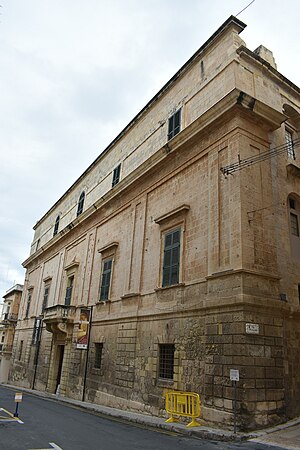
The Auberge d'Allemagne (Maltese: Auberge d'Allemagne) was an auberge in Birgu, Malta. It was built in the 16th century to house knights of the Order of Saint John from the langue of Germany.

Auberge d'Angleterre
Auberge in Birgu, Malta
Distance: Approx. 47 meters
Latitude and longitude: 35.88819444,14.52261111
Auberge d'Angleterre (Maltese: Berġa tal-Ingilterra) is an auberge in Birgu, Malta. It was built around 1534 (incorporating an earlier building) to house knights of the Order of Saint John from the langue of England (whose members came from England, Scotland, and Ireland). It now houses a health centre, and is the best-preserved Hospitaller auberge in Birgu.

Auberge d'Aragon, Birgu
Auberge in Birgu, Malta
Distance: Approx. 100 meters
Latitude and longitude: 35.88855556,14.52305556
The Auberge d'Aragon (Maltese: Berġa ta' Aragona) is an auberge in Birgu, Malta. It was built in the 16th century to house knights of the Order of Saint John from the langue of Aragon, Navarre and Catalonia. The auberge was located within Birgu's collachio, adjacent to Auberge d'Auvergne et Provence and Auberge de France.

Auberge de France, Birgu
Auberge in Birgu, Malta
Distance: Approx. 82 meters
Latitude and longitude: 35.8885,14.52286111
Auberge de France (Maltese: Berġa ta' Franza) is an auberge in Birgu, Malta. It was built around 1533 (incorporating an earlier building) to house knights of the Order of Saint John from the langue of France, which induced the entire Kingdom of France except for Auvergne and Provence which were separate langues. The building housed the French langue until a new Auberge de France was opened in Valletta.
Monastery of St. Scholastica
Distance: Approx. 91 meters
Latitude and longitude: 35.8889,14.5223
The Monastery of St. Scholastica is a monastery in Birgu, Malta. The monastery is dedicated to Santa Scholastica, but the church is dedicated to St Anne.

Chapel of Our Lady of Damascus, Birgu
Church in Birgu, Malta
Distance: Approx. 55 meters
Latitude and longitude: 35.88766667,14.52180556
The Chapel of Our Lady of Damascus also known in Maltese as Tal-Griegi is a former Greek Catholic church located in the town of Birgu, Malta. Nowadays it is part of the Oratory of St Joseph.

District 2, Malta
Distance: Approx. 222 meters
Latitude and longitude: 35.88611111,14.52222222
District 2 is an electoral district in Malta. It was established in 1921. Its boundaries have changed many times but it currently consists of the localities of Birgu, Senglea, Cospicua, Żabbar, Kalkara, Xgħajra and part of Fgura.

Bishop's Palace, Birgu
Palace in Birgu, Malta
Distance: Approx. 154 meters
Latitude and longitude: 35.88725,14.52344444
The Bishop's Palace (Maltese: Il-Palazz tal-Isqof) is a palatial building in Birgu, Malta which was a residence of the Roman Catholic Bishops of Malta. It was constructed in the 16th century.
Weather in this IP's area
few clouds
20 Celsius
20 Celsius
20 Celsius
21 Celsius
1017 hPa
64 %
1017 hPa
1016 hPa
10000 meters
5.66 m/s
280 degree
20 %
06:40:34
16:53:35

