Country:
 Canada
Region:
City:
Latitude and Longitude:
Time Zone:
Postal Code:
IP information under different IP Channel
ip-api
Country
Region
City
ASN
Time Zone
ISP
Blacklist
Proxy
Latitude
Longitude
Postal
Route
Luminati
Country
 IM
IMASN
Time Zone
Europe/Isle_of_Man
ISP
CL-1379-14537
Latitude
Longitude
Postal
IPinfo
Country
Region
City
ASN
Time Zone
ISP
Blacklist
Proxy
Latitude
Longitude
Postal
Route
db-ip
Country
Region
City
ASN
Time Zone
ISP
Blacklist
Proxy
Latitude
Longitude
Postal
Route
ipdata
Country
Region
City
ASN
Time Zone
ISP
Blacklist
Proxy
Latitude
Longitude
Postal
Route
Popular places and events near this IP address

Place Ville Marie
Office skyscraper and shopping complex in Montreal, Quebec, Canada
Distance: Approx. 90 meters
Latitude and longitude: 45.5015,-73.5684
Place Ville Marie (PVM for short) is a large office and shopping complex skyscraper in Downtown Montreal, Quebec, Canada, comprising four office buildings and an underground shopping plaza. The main building, 1 Place Ville Marie (formerly Royal Bank Tower from its anchor tenant), was built in the International style in 1962 as the headquarters for the Royal Bank of Canada. While RBC's corporate headquarters and the majority of its management operations have been based in Toronto's Royal Bank Plaza since 1976, Place Ville Marie remains RBC's head office, a distinct title from its corporate headquarters.
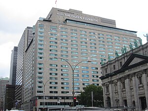
Queen Elizabeth Hotel
Building in Montreal, Quebec, Canada
Distance: Approx. 148 meters
Latitude and longitude: 45.5006,-73.5678
Fairmont The Queen Elizabeth (French: Fairmont Le Reine Élizabeth) is a historic grand hotel in Montreal, Quebec, Canada. With 950 rooms and 21 floors it is the largest hotel in Quebec, and the second largest Fairmont hotel in Canada after the Fairmont Royal York in Toronto. Located at 900 René Lévesque Boulevard West, in Downtown Montreal, it is connected to Central Station and to the underground city.

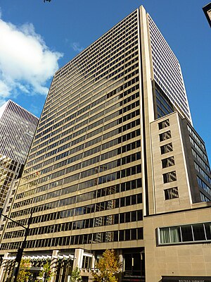
Telus Tower (Montreal)
Office in Quebec, Canada
Distance: Approx. 58 meters
Latitude and longitude: 45.5024,-73.5676
The Telus Tower is an office building at 630 René Lévesque Boulevard West in Montreal. It was built for Canadian Industries Limited from 1960 to 1962, given the name CIL House. Designed by architect Gordon Bunshaft from the architectural firm Skidmore, Owings and Merrill with local architects Greenspoon, Freedlander and Dunne, it stands 135.6 m (445 ft) and 34 storeys tall.

Blue Bird Café fire
1972 nightclub fire in Montreal, Canada
Distance: Approx. 109 meters
Latitude and longitude: 45.502745,-73.566701
The Blue Bird Café fire was a nightclub fire on September 1, 1972, in Montreal, Quebec, Canada. In all, 37 people were killed as a result of arson. The fire was the worst in Montreal since 1927, when 77 people perished in the Laurier Palace Theatre Fire.
Terminal Tower (Montreal)
Office in Quebec, Canada
Distance: Approx. 50 meters
Latitude and longitude: 45.501454,-73.56735
The Terminal Tower (also known as Le 800 René Lévesque) is a skyscraper in downtown Montreal, Quebec, Canada. It is 30 storeys, and 125 metres (410 ft) tall. Completed in 1966, it was the last phase of CN's developments in the area, along with the Queen Elizabeth Hotel, Central Station and the CN Building.
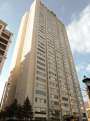
Le Port-Royal Apartments
Apartments in Montreal, Quebec
Distance: Approx. 84 meters
Latitude and longitude: 45.50123,-73.5679
Le Port-Royal (also known as Port-Royal Apartments) is an apartment building on Sherbrooke Street in the Golden Square Mile district of Montreal, Quebec, Canada. It is 33 stories, and 122 metres (400 ft) tall. Completed in 1964, it used to be the highest residential building in Canada east of Toronto until the completion of Altitude Montreal in 2013.
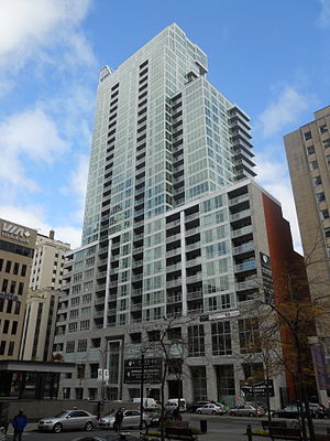
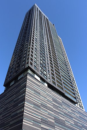
Altitude Montreal
Condominiums in Quebec, Canada
Distance: Approx. 84 meters
Latitude and longitude: 45.5025,-73.56805556
Altitude Montreal is a 33-storey, 124 m (407 ft) skyscraper in Montreal, Quebec, Canada. It is located at 1225 Robert-Bourassa Boulevard at the corner of Cathcart Street in Downtown Montreal, opposite Place Ville-Marie. This modern skyscraper was designed by some of the same architects who were behind the Louvre Pyramid.

Architects' Building (Montreal)
Office building in Quebec, Canada
Distance: Approx. 173 meters
Latitude and longitude: 45.5031,-73.566
The Architects' Building was an office building located in Montreal, Quebec, Canada. It was located at 1135 Beaver Hall Hill, on the southeast corner of Dorchester Boulevard (now René Lévesque Boulevard) in Downtown Montreal. It was designed by Montreal architecture firm Ross and Macdonald, and was constructed between 1930 and 1931.
Tour des Canadiens
Condominium skyscraper complex in Montreal, Quebec, Canada
Distance: Approx. 91 meters
Latitude and longitude: 45.5025,-73.5682
The Tour des Canadiens is a condominium skyscraper complex in Montreal, Quebec, Canada. It is situated next to the Bell Centre in downtown Montreal, at Avenue des Canadiens-de-Montréal and Rue de la Montagne, and is named for the Montreal Canadiens hockey team, which is a part-owner of the project. The first tower consists of 552 condos, with nine floors of parking and a large sports bar on the ground floor.

Tom Condos
Condominiums in Quebec, Canada
Distance: Approx. 105 meters
Latitude and longitude: 45.5028,-73.5678
Tom Condos is a skyscraper in Montreal, Quebec, Canada. The tower is located on Union Avenue between René-Lévesque Boulevard and Cathcart Street, near the Altitude Montreal tower and the Place Ville Marie. Part of the building occupies the site of 1972's Blue Bird Café fire.

Statue of André Bessette
Sculpture in Montreal, Canada
Distance: Approx. 171 meters
Latitude and longitude: 45.50334,-73.56664
The Statue of André Bessette (French: Monument au Frère André) is an outdoor bronze sculpture in Place du frère Andre, Montreal, Quebec, Canada. The monument is of André Bessette, more commonly known as Brother André (French: Frère André), and since his canonization as Saint André. The statue was created by Canadian sculptor Émile Brunet.

Female Landscape
1972 sculpture by Gerald Galdstone
Distance: Approx. 195 meters
Latitude and longitude: 45.5013,-73.56975
Female Landscape, or Feminine Landscape, is an outdoor 1972 sculpture by Gerald Gladstone, installed in a fountain in the outdoor plaza of Montreal's Place Ville Marie complex, in Quebec, Canada.
Weather in this IP's area
clear sky
2 Celsius
-3 Celsius
1 Celsius
3 Celsius
1022 hPa
63 %
1022 hPa
1020 hPa
10000 meters
5.14 m/s
40 degree
06:52:42
16:25:05