Country:
 Ireland
Region:
City:
Latitude and Longitude:
Time Zone:
Postal Code:
IP information under different IP Channel
ip-api
Country
Region
City
ASN
Time Zone
ISP
Blacklist
Proxy
Latitude
Longitude
Postal
Route
IPinfo
Country
Region
City
ASN
Time Zone
ISP
Blacklist
Proxy
Latitude
Longitude
Postal
Route
MaxMind
Country
Region
City
ASN
Time Zone
ISP
Blacklist
Proxy
Latitude
Longitude
Postal
Route
Luminati
Country
 IM
IMASN
Time Zone
Europe/Isle_of_Man
ISP
Interactive Sports Limited
Latitude
Longitude
Postal
db-ip
Country
Region
City
ASN
Time Zone
ISP
Blacklist
Proxy
Latitude
Longitude
Postal
Route
ipdata
Country
Region
City
ASN
Time Zone
ISP
Blacklist
Proxy
Latitude
Longitude
Postal
Route
Popular places and events near this IP address

Park Avenue, Dublin
Road in Dublin, Ireland
Distance: Approx. 612 meters
Latitude and longitude: 53.32533889,-6.21307778
Park Avenue (Irish: Ascaill na Páirce) in the suburb of Sandymount, Dublin 4, Ireland is the name of a road joining Sydney Parade Avenue to Gilford Road. It is home to a number of cricket and rugby union grounds including Pembroke Cricket Club, the Railway Union Sports Club and Monkstown Rugby Club. Of architectural note is the Church of St John (Church of Ireland), noted for its French Bath stone's decay due to its proximity to the sea.

Sandymount railway station
Railway (DART) station in Dublin, Ireland
Distance: Approx. 477 meters
Latitude and longitude: 53.32795,-6.22138
Sandymount railway station (Irish: Stáisiún Dhumhach Thrá), also known as Sandymount DART station, serves Sandymount and Ballsbridge (including RDS Simmonscourt) in Dublin, Ireland. It has two platforms, both fully accessible via ramps. There is a level crossing as the railway line crosses Sandymount Avenue.
Sandymount High School
School in Dublin, Ireland
Distance: Approx. 725 meters
Latitude and longitude: 53.3335,-6.2255
Sandymount High School was a coeducational secondary school on Herbert Road, Sandymount, Dublin 4 which operated for over 50 years before closing in 1999.
Sandymount Avenue
Road in Dublin, Ireland
Distance: Approx. 360 meters
Latitude and longitude: 53.328363,-6.219648
Sandymount Avenue (Irish: Ascaill Dhumhach Thrá) joins Merrion Road to Gilford Road in Sandymount, Dublin. Sandymount railway station is located roughly halfway along it at a level crossing. It is a residential area.

Newbridge Avenue
Road
Distance: Approx. 748 meters
Latitude and longitude: 53.335365,-6.22368
Newbridge Avenue (Irish: Ascaill an Droichid Nua) is a road in the Sandymount district of Dublin which links Herbert Road and Tritonville Road. In the novel Ulysses, the funeral of the character Paddy Dignam starts here at number 9 and continues on to Glasnevin Cemetery via Tritonville Road. The Dignams were said to live at number 9; the property was, in reality, vacant in 1904.

Herbert Road
Road in Ballsbridge, Ireland
Distance: Approx. 643 meters
Latitude and longitude: 53.3336,-6.224
Herbert Road (Irish: Bóthar Hoirbeaird) in Ballsbridge, Ireland is a mostly residential road that links Tritonville Road with Lansdowne Road. Newbridge Avenue joins by the bridge, in front of Marian College and the former site of Sandymount High School next door. There are several hotels on the road.

Tritonville Road
Road in Dublin, Ireland
Distance: Approx. 549 meters
Latitude and longitude: 53.333944,-6.2218
Tritonville Road (Irish: Bóthar Tritonville), Sandymount, Dublin 4, is connected to Lansdowne Road by both Herbert Road and Newbridge Avenue. At its southern end, it meets Serpentine Avenue. The northern side of Tritonville road is considered to be part of Irishtown by the locals even though the postcode is Sandymount.
Mount Herbert Hotel
Hotel in Dublin, Ireland
Distance: Approx. 682 meters
Latitude and longitude: 53.333548,-6.22474
Sandymount Hotel (formerly the Mount Herbert Hotel) is a 4 star hotel in Dublin, Ireland, sited on the old Haig's Distillery. The hotel consists of 8 interconnected Victorian houses which were originally constructed in 1866 and built with bricks from the old distillery.
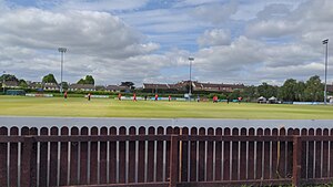
Claremont Road Cricket Ground
Sports facility, Dublin, Ireland
Distance: Approx. 287 meters
Latitude and longitude: 53.33016,-6.22
Claremont Road is a cricket ground in Dublin, Ireland. The first recorded match held on the ground came in 1994, when Munster played North West. In local domestic cricket, the ground was the home of YMCA Cricket Club.
Sydney Parade
Cricket ground
Distance: Approx. 626 meters
Latitude and longitude: 53.32498889,-6.215075
Sydney Parade is a cricket ground in Dublin, Ireland. The first recorded match on the ground was in 1897, when Pembroke played Leicester Ivanhoe. In 1965, the ground hosted a first-class match between Ireland and Scotland, which resulted in a Scottish victory by an innings and 22 runs.
New Bridge (Dublin)
Bridge over the River Dodder in Ireland
Distance: Approx. 765 meters
Latitude and longitude: 53.334367,-6.225365
The New Bridge is a bridge over the River Dodder in Dublin, Ireland. It is also known as Herbert's Bridge or Lansdowne Bridge. The bridge is part of Lansdowne Road.

Clanna Gael Fontenoy GAA
Gaelic games club in Dublin, Ireland
Distance: Approx. 790 meters
Latitude and longitude: 53.337689,-6.21636
Clanna Gael Fontenoy is a Gaelic Athletic Association club based at Ringsend, Dublin, Ireland, serving Sandymount, Irishtown, Ringsend and its surrounding areas.
Weather in this IP's area
mist
16 Celsius
16 Celsius
15 Celsius
17 Celsius
1008 hPa
93 %
1008 hPa
1007 hPa
5000 meters
4.63 m/s
260 degree
75 %
06:47:07
19:58:07