193.30.166.115 - IP Lookup: Free IP Address Lookup, Postal Code Lookup, IP Location Lookup, IP ASN, Public IP
Country:
Region:
City:
Location:
Time Zone:
Postal Code:
ISP:
ASN:
language:
User-Agent:
Proxy IP:
Blacklist:
IP information under different IP Channel
ip-api
Country
Region
City
ASN
Time Zone
ISP
Blacklist
Proxy
Latitude
Longitude
Postal
Route
db-ip
Country
Region
City
ASN
Time Zone
ISP
Blacklist
Proxy
Latitude
Longitude
Postal
Route
IPinfo
Country
Region
City
ASN
Time Zone
ISP
Blacklist
Proxy
Latitude
Longitude
Postal
Route
IP2Location
193.30.166.115Country
Region
nordland
City
mo i rana
Time Zone
Europe/Oslo
ISP
Language
User-Agent
Latitude
Longitude
Postal
ipdata
Country
Region
City
ASN
Time Zone
ISP
Blacklist
Proxy
Latitude
Longitude
Postal
Route
Popular places and events near this IP address

Mo i Rana
City in Nordland, Norway
Distance: Approx. 0 meters
Latitude and longitude: 66.3128,14.1428
Mo i Rana (Norwegian; pronounced [ˈmuː ɪ ˈrɑ̀ːnɑ]) or Måefie (Southern Sami) (and unofficially Ume Sami: Måhvie, Northern Sami: Muoffie) is a city, and the administrative centre of Rana Municipality in Nordland county, Norway. It is located in the Helgeland region of Nordland, just south of the Arctic Circle. Some of the city's suburbs include Båsmoen and Ytteren in the north, Gruben in the south east, Selfors in the east, and Åga/Hauknes/Dalsgrenda in the south.
Tverråga
River in Nordland, Norway
Distance: Approx. 1875 meters
Latitude and longitude: 66.32169,14.17841
Tverråga is a river in Rana Municipality in Nordland county, Norway. The river flows from lake Tverrvatnet north until it joins the river Ranelva. The river absorbs seven other rivers during its course, the last one by Hamaren near the village of Gruben.
Selfors
Village in Rana Municipality, Norway
Distance: Approx. 2112 meters
Latitude and longitude: 66.3269,14.1744
Selfors is a neighborhood in the town of Mo i Rana in Rana Municipality in Nordland county, Norway. Selfors sits on the northern shore of the river Ranelva in the northeastern part of the town of Mo i Rana. The European route E06 highway passes through the neighborhood.

Mo Industrial Park
Distance: Approx. 1222 meters
Latitude and longitude: 66.3093,14.1687
Mo Industrial Park (Norwegian: Mo Industripark) is one of Norway's largest industrial parks, situated in the town of Mo i Rana, North Norway. The company Mo Industrial Park produces oxygen, nitrogen and compressed air, and also provides security, telephone-switchboard and mail services to the other companies in the park. The companies engage in a wide range of activities, including iron and steel production, ferroalloy production, workshop industry, service industry, research, quality and computer technology, expertise industry, and even fish farming.

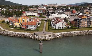
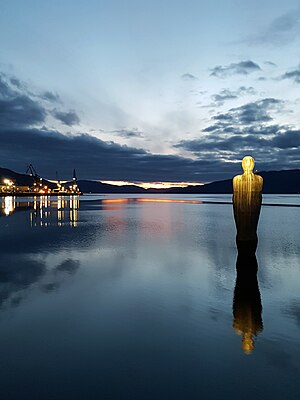
Havmannen
Sculpture by Antony Gormley
Distance: Approx. 740 meters
Latitude and longitude: 66.31027778,14.1275
Havmannen, or Havmann (in English: "The Man from the Sea"), is a granite stone sculpture by the English artist Antony Gormley located in the city of Mo i Rana in northern Norway. The sculpture stands proud in the "Ranfjord" in the city of Mo i Rana, which is often referred to in Norway as "Polarsirkelbyen" (in English: the "Arctic Circle City"). The sculpture is 11 metres (36 ft) tall, weighs 60 tonnes (59 long tons; 66 short tons), and according to Lonely Planet is "forever up to his knees in water, turns his back on the town and gazes resolutely out over the fjord".
Helgeland Hospital Trust
Norwegian health trust
Distance: Approx. 2472 meters
Latitude and longitude: 66.3263,14.1867
Helgeland Hospital Trust is a health trust covering Helgeland in Nordland, Norway. It is part of Northern Norway Regional Health Authority and was established on 1 January 2002. The main facilities are in Mo i Rana, Mosjøen and Sandnessjøen Hospital.
Mo i Rana Station
Railway station in Rana, Norway
Distance: Approx. 513 meters
Latitude and longitude: 66.31055556,14.13277778
Mo i Rana Station (Norwegian: Mo i Rana stasjon) is a railway station located in the town of Mo i Rana in Rana Municipality in Nordland county, Norway. The station is located along the Nordland Line and has been in operation since 1942. Since 10 January 1943, Norsk Spisevognselskap has operated a restaurant at the station.
Gruben Church
Church in Nordland, Norway
Distance: Approx. 2342 meters
Latitude and longitude: 66.31585028,14.19462427
Gruben Church (Norwegian: Gruben kirke) is a parish church of the Church of Norway in Rana Municipality in Nordland county, Norway. It is located in the eastern part of the town of Mo i Rana. It is the church for the Gruben parish which is part of the Indre Helgeland prosti (deanery) in the Diocese of Sør-Hålogaland.

Mo Church (Nordland)
Church in Nordland, Norway
Distance: Approx. 326 meters
Latitude and longitude: 66.3099338,14.1443363
Mo Church (Norwegian: Mo kirke) is a parish church of the Church of Norway in Rana Municipality in Nordland county, Norway. It is located in the town of Mo i Rana. It is the church for the Mo parish which is part of the Indre Helgeland prosti (deanery) in the Diocese of Sør-Hålogaland.
Selfors Church
Church in Nordland, Norway
Distance: Approx. 1833 meters
Latitude and longitude: 66.32499835,14.17032748
Selfors Church (Norwegian: Selfors kirke) is a rented chapel of the Church of Norway in Rana Municipality in Nordland county, Norway. It is located in the village of Selfors. It is an annex chapel for the Nord-Rana parish which is part of the Indre Helgeland prosti (deanery) in the Diocese of Sør-Hålogaland.

Rana District Court
District court in Rana, Norway
Distance: Approx. 294 meters
Latitude and longitude: 66.31104,14.13789
Rana District Court (Norwegian: Rana tingrett) was a district court in Nordland county, Norway. The court was based in the town of Mo i Rana. The court existed from 1859 until 2021.

Helgeland District Court
First-instance law court in Norway
Distance: Approx. 295 meters
Latitude and longitude: 66.311035,14.137891
Helgeland District Court (Norwegian: Helgeland tingrett) is a district court located in Nordland county, Norway. This court is based at three different courthouses which are located in Brønnøysund, Mo i Rana, and Sandnessjøen. The court serves the southern part of the county which includes cases from 17 municipalities.
Weather in this IP's area
broken clouds
-5 Celsius
-12 Celsius
-5 Celsius
-5 Celsius
1020 hPa
58 %
1020 hPa
965 hPa
10000 meters
7.72 m/s
90 degree
75 %


