193.29.226.134 - IP Lookup: Free IP Address Lookup, Postal Code Lookup, IP Location Lookup, IP ASN, Public IP
Country:
 Armenia
Region:
City:
Location:
Time Zone:
Postal Code:
ISP:
ASN:
language:
User-Agent:
Proxy IP:
Blacklist:
IP information under different IP Channel
ip-api
Country
Region
City
ASN
Time Zone
ISP
Blacklist
Proxy
Latitude
Longitude
Postal
Route
db-ip
Country
Region
City
ASN
Time Zone
ISP
Blacklist
Proxy
Latitude
Longitude
Postal
Route
IPinfo
Country
Region
City
ASN
Time Zone
ISP
Blacklist
Proxy
Latitude
Longitude
Postal
Route
IP2Location
193.29.226.134Country
amRegion
armavir
City
baghramyan
Time Zone
Asia/Yerevan
ISP
Language
User-Agent
Latitude
Longitude
Postal
ipdata
Country
Region
City
ASN
Time Zone
ISP
Blacklist
Proxy
Latitude
Longitude
Postal
Route
Popular places and events near this IP address

Zvartnots, Armenia
Town in Armavir, Armenia
Distance: Approx. 4551 meters
Latitude and longitude: 40.1625,44.40333333
Zvartnots (Armenian: Զվարթնոց, romanized: Zvart'nots', lit. 'celestial angels', IPA: [zəvɑɾtʰˈnɔtsʰ] (Western Armenian)) is a town in the Armenian province of Armavir, about 10 km west from Yerevan, approximately halfway to Ejmiatsin. Zvartnots International Airport, Yerevan's international airport, is located near the town of Zvartnots, as is the Zvartnots Cathedral. The former national airline, Armavia, had its corporate headquarters on the grounds of Zvartnots International Airport.
Ptghunk
Place in Armavir, Armenia
Distance: Approx. 3248 meters
Latitude and longitude: 40.16444444,44.36361111
Ptghunk (Armenian: Պտղունք, also Romanized as Ptghunk’, Ptghounq, and Ptkhunk) is a village in the Armenian province of Armavir. The village is about 10 miles from Yerevan on the road to Komitas, and is close to the Zvartnots airport. According to the 2011 census, the population of Ptghunk is 1,795.
Merdzavan
Place in Armavir, Armenia
Distance: Approx. 3076 meters
Latitude and longitude: 40.17972222,44.39972222
Merdzavan (Armenian: Մերձավան), is a village in the Armavir Province of Armenia, located at the western suburbs of the capital Yerevan, north of the Parakar village. As of the 2011 official census, Merdzavan has a population of 3,303.
Norakert
Place in Armavir, Armenia
Distance: Approx. 1844 meters
Latitude and longitude: 40.19222222,44.34666667
Norakert (Armenian: Նորակերտ) is a town in the Armavir Province of Armenia.

Parakar
Place in Armavir, Armenia
Distance: Approx. 4581 meters
Latitude and longitude: 40.16388889,44.40583333
Parakar (Armenian: Փարաքար), formerly Shirabad, is a village in the Parakar Municipality of the Armavir Province of Armenia. According to the 2010 official estimate, the population of Parakar is 9,297 (including Tairov). The village is notable for its gypsum mine.
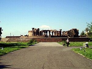
Zvartnots Cathedral
Cathedral in Armenia
Distance: Approx. 4620 meters
Latitude and longitude: 40.159714,44.336575
Zvartnots Cathedral (Armenian: Զուարթնոց (classical); Զվարթնոց (reformed), sometimes rendered in scholarly works as Zuart'nots' or Zuart'noc' ; lit. 'place of reserection/lifefulness/joyfulness') is a medieval Armenian cathedral near Vagharshapat (Ejmiatsin), Armenia. Built in the seventh century and now lying in ruins, Zvartnots was noted for its circular exterior structure, unique in medieval Armenian architecture, and a set of interior piers that upheld a multifloor structure crowned with a dome.
Aygek
Place in Armavir, Armenia
Distance: Approx. 1385 meters
Latitude and longitude: 40.18861111,44.38333333
Aygek (Armenian: Այգեկ) is a village and a rural community in the Armavir Province of Armenia. It is located 8 km west of the capital Yerevan and 36 km east of the provincial centre Armavir. It has an elevation of 870 metres above sea level.
Baghramyan, Parakar
Place in Armavir, Armenia
Distance: Approx. 27 meters
Latitude and longitude: 40.19333333,44.36861111
Baghramyan (Armenian: Բաղրամյան) is a village in the Armavir Province of Armenia. It is named after the Soviet Armenian military commander and Marshal of the Soviet Union Ivan Bagramyan.
Ginevet, Armavir
Place in Armavir, Armenia
Distance: Approx. 4815 meters
Latitude and longitude: 40.15055556,44.36055556
Ginevet is an abandoned settlement and a former village in the Armavir Province of Armenia.
Haghtanak, Yerevan
Place in Yerevan, Armenia
Distance: Approx. 4791 meters
Latitude and longitude: 40.18638889,44.42388889
Haghtanak (Armenian: Հաղթանակ, also, Haght’anak, Akhtanak, and Chorort Gyukh) is a neighbourhood in the Yerevan Province of Armenia.

Musaler
Place in Armavir, Armenia
Distance: Approx. 4411 meters
Latitude and longitude: 40.15444444,44.37777778
Musaler (Armenian: Մուսալեռ) is a village in the Armavir Province of Armenia. The village was renamed in 1972 after Musa Ler, the site of Armenian resistance in 1915.

Civil Aviation Museum (Armenia)
Distance: Approx. 5218 meters
Latitude and longitude: 40.152458,44.398169
The Civil Aviation Museum of Armenia (Armenian: Հայկական ավիացիայի պատմության թանգարան) was founded in 1998, on the 65th anniversary of civil aviation in Armenia. Located in Zvartnots, Armenia, the museum contains documents, collections, photographs, books and other valuable items that reflect the history of civil aviation.
Weather in this IP's area
mist
-5 Celsius
-5 Celsius
-5 Celsius
-5 Celsius
1027 hPa
74 %
1027 hPa
925 hPa
3500 meters