193.27.86.76 - IP Lookup: Free IP Address Lookup, Postal Code Lookup, IP Location Lookup, IP ASN, Public IP
Country:
Region:
City:
Location:
Time Zone:
Postal Code:
IP information under different IP Channel
ip-api
Country
Region
City
ASN
Time Zone
ISP
Blacklist
Proxy
Latitude
Longitude
Postal
Route
Luminati
Country
ASN
Time Zone
Europe/Amsterdam
ISP
Trans-iX B.V.
Latitude
Longitude
Postal
IPinfo
Country
Region
City
ASN
Time Zone
ISP
Blacklist
Proxy
Latitude
Longitude
Postal
Route
IP2Location
193.27.86.76Country
Region
drenthe
City
assen
Time Zone
Europe/Amsterdam
ISP
Language
User-Agent
Latitude
Longitude
Postal
db-ip
Country
Region
City
ASN
Time Zone
ISP
Blacklist
Proxy
Latitude
Longitude
Postal
Route
ipdata
Country
Region
City
ASN
Time Zone
ISP
Blacklist
Proxy
Latitude
Longitude
Postal
Route
Popular places and events near this IP address
Assen
City and municipality in Drenthe, Netherlands
Distance: Approx. 483 meters
Latitude and longitude: 53,6.56666667
Assen (Dutch: [ˈɑsə(n)] ) is a city and municipality in the Northeastern Netherlands, and is the capital of the province of Drenthe. It received city rights in 1809. Assen is known for TT Circuit Assen, the motorcycle racing circuit, where on the last Sunday in June the Dutch TT is run; and also for the annual Assen Dance Festival.

Deurze
Village in Drenthe, Netherlands
Distance: Approx. 3497 meters
Latitude and longitude: 52.98361111,6.60916667
Deurze is a village in the Dutch province of Drenthe. It is a part of the municipality of Aa en Hunze, and lies about 4 km southeast of Assen.

De Bonte Wever
Distance: Approx. 2063 meters
Latitude and longitude: 52.983254,6.540792
De Bonte Wever (formerly De Smelt) is a sports arena located in Assen, Netherlands. De venue opened in the 1970s with a 400-meter speed skating track. Later an ice hockey hall was added.

Anreep
Hamlet in Drenthe, Netherlands
Distance: Approx. 2785 meters
Latitude and longitude: 52.97638889,6.58583333
Anreep is a hamlet in the Netherlands and is part of the Assen municipality in Drenthe. Anreep is a statistical entity with Schieven, however the postal authority have placed it under Assen. It was first mentioned in 1217 as Anrepe and means "higher piece of land near water".

Schieven
Hamlet in Drenthe, Netherlands
Distance: Approx. 2685 meters
Latitude and longitude: 52.98,6.59055556
Schieven is a hamlet in the Netherlands and is part of the Assen municipality in Drenthe. Schieven is a statistical entity with Anreep, however the postal authority have placed it under Assen. It was first mentioned in 1460 as "Johan Scheuen ...

Ter Aard
Hamlet in Drenthe, Netherlands
Distance: Approx. 3354 meters
Latitude and longitude: 53.0251,6.5446
Ter Aard is a hamlet in the Netherlands and is part of the Assen municipality in Drenthe. Ter Aard is a statistical entity, and has its own postal code, however it is considered a part of Zeijen. It was first mentioned in 1335 as "in Arth" and means "near the farmland".

Graswijk
Hamlet in Drenthe, Netherlands
Distance: Approx. 2394 meters
Latitude and longitude: 52.9756,6.5558
Graswijk is a hamlet in the Netherlands and is part of the Assen municipality in Drenthe. Graswijk is a statistical entity, but the postal authorities have placed it under Assen. It was first mentioned in the 1850s, and means neighbourhood near grass.

1978 Dutch province hall hostage crisis
Distance: Approx. 1971 meters
Latitude and longitude: 52.9854,6.5393
On the morning of Monday 13 March 1978, at 10:15, three South-Moluccans seized the Province Hall in Assen, Netherlands. Some of the people inside escaped by jumping out of the window, including the Queen's Commissioner of the Drenthe province. 16 women and 55 men were taken hostage.

Assen railway station
Railway station in Assen, Netherlands
Distance: Approx. 819 meters
Latitude and longitude: 52.99166667,6.57055556
Assen (Dutch pronunciation: [ˈɑsə(n)] ; abbreviation: Asn) is a railway station located in Assen, Netherlands. The station was opened on 1 May 1870 and is located on the Meppel–Groningen railway. The station is operated by Nederlandse Spoorwegen.
Drents Museum
History museum in the Netherlands
Distance: Approx. 427 meters
Latitude and longitude: 52.9933,6.5644
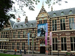
The Drents Museum (Dutch pronunciation: [ˈdrɛnts myˈzeːjʏm]) is an art and history museum in Assen, Drenthe, in the Netherlands. The museum was opened in 1854. It has a collection of prehistorical artifacts, applied art, and visual art.
Assen-Zuid railway station
Distance: Approx. 1534 meters
Latitude and longitude: 52.98333333,6.56666667
Assen-Zuid (English: Assen South) is a planned railway station in Assen, Netherlands. Assen city official Alex Langius said in February 2012 that the station is expected to be built south of the N33 road, between Assen railway station and Beilen railway station, along the existing Meppel-Groningen railway. Langius described the station as an 'events station', meaning it would be used to transport train passengers to events such as those at motorsport race track TT Circuit Assen.

Marienkamp Abbey
Distance: Approx. 414 meters
Latitude and longitude: 52.9933,6.5639
Marienkamp Abbey (Dutch: Klooster Mariënkamp; Latin: Maria in Campis) was a Cistercian nunnery in the present province of Drenthe in the Netherlands.
Weather in this IP's area
overcast clouds
1 Celsius
-4 Celsius
-0 Celsius
2 Celsius
1037 hPa
85 %
1037 hPa
1036 hPa
10000 meters
4.63 m/s
200 degree
100 %

