Country:
Region:
City:
Latitude and Longitude:
Time Zone:
Postal Code:
IP information under different IP Channel
ip-api
Country
Region
City
ASN
Time Zone
ISP
Blacklist
Proxy
Latitude
Longitude
Postal
Route
Luminati
Country
Region
vc
City
elche
ASN
Time Zone
Europe/Madrid
ISP
Cable Aireworld S.A.U.
Latitude
Longitude
Postal
IPinfo
Country
Region
City
ASN
Time Zone
ISP
Blacklist
Proxy
Latitude
Longitude
Postal
Route
db-ip
Country
Region
City
ASN
Time Zone
ISP
Blacklist
Proxy
Latitude
Longitude
Postal
Route
ipdata
Country
Region
City
ASN
Time Zone
ISP
Blacklist
Proxy
Latitude
Longitude
Postal
Route
Popular places and events near this IP address

Elche
Municipality in Valencian Community, Spain
Distance: Approx. 173 meters
Latitude and longitude: 38.26694444,-0.69833333
Elche (, Spanish: [ˈeltʃe]; Valencian: Elx, UK: , US: , Valencian: [ˈɛʎtʃ] is a city and municipality of Spain, belonging to the province of Alicante, in the Valencian Community. According to 2024's data, Elche has a population of 234,800 inhabitants, making it the third most populated municipality in the region (after Valencia and Alicante) and the 20th largest Spanish municipality. It is part of the comarca of Baix Vinalopó.
Crevillent
Municipality in Valencian Community, Spain
Distance: Approx. 9728 meters
Latitude and longitude: 38.24861111,-0.80888889
Crevillent (Valencian: [kɾeviˈʎent]; Spanish: Crevillente [kɾeβiˈʎente]) is a town and municipality located in the Alicante province, part of the Valencian Community, Spain. It is situated in the comarca of Baix Vinalopó, and lies at the foot of the hill range known locally as Serra de Crevillent. As of 2009, it has a total population of 28,609 inhabitants.

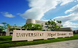
Miguel Hernández University of Elche
Distance: Approx. 1701 meters
Latitude and longitude: 38.275,-0.68416667
The Miguel Hernández University (UMH, Spanish: Universidad Miguel Hernández, Valencian: Universitat Miguel Hernández, Latin: Universitas Miguel Hernández illicitana), is a Spanish Public University offering education, research and services facilitating the comprehensive development of its students. It is located in the province of Alicante and was established in 1996. Its name commemorates the Spanish poet Miguel Hernández.

Baix Vinalopó
Comarca in Valencian Community, Spain
Distance: Approx. 550 meters
Latitude and longitude: 38.26166667,-0.70305556
The Baix Vinalopó (Valencian: [ˈbajʒ vinaloˈpo], also [ˈbaʒ-]; Spanish: Bajo Vinalopó [ˈbaxo βinaloˈpo]; lit. "Lower Vinalopó") is a comarca in the province of Alicante (Valencian Community, Spain). It is bordered by the comarques of Vinalopó Mitjà and Alacantí on the north and Vega Baja del Segura on the south.
Mystery Play of Elche
Cultural property in Elche, Spain
Distance: Approx. 173 meters
Latitude and longitude: 38.26694444,-0.69833333
The Mystery Play of Elche or Elche Mystery Play (Valencian: Misteri d'Elx [misˈtɛɾi ˈðɛʎtʃ]; Spanish: Misterio de Elche [misˈteɾjo ˈð(e) ˈeltʃe]), is a liturgical drama from the Middle Ages that reenacts the Dormition and Assumption of the Blessed Virgin Mary. The two-act mystery play is performed annually on 14 and 15 August in the Basilica de Santa María in the city of Elche. In 2001, UNESCO declared it one of the Masterpieces of the Oral and Intangible Heritage of Humanity and, in 2008, inscribed it on its Representative List.

Estadio Martínez Valero
Stadium in Elche, Spain
Distance: Approx. 3189 meters
Latitude and longitude: 38.26694444,-0.66333333
The Estadio Martínez Valero is a stadium located in the Spanish city of Elche in the province of Alicante, Valencian Community. It is the home stadium of Elche CF, a team that is currently playing in Segunda División. Its name pays tribute to the late president of the club, Manuel Martínez Valero.

Palmeral of Elche
System of orchards in Elche, Spain
Distance: Approx. 483 meters
Latitude and longitude: 38.27,-0.698
The Palmeral or Palm Grove of Elche (Spanish: Palmeral de Elche; Valencian: Palmerar d'Elx) is the generic name for a system of date palm orchards in the city of Elche, Spain. The Palmeral was planted in Roman times and underwent modifications in the medieval period under Islamic and Christian rulers. The Roman empire introduced water management techniques to Elche, but the 10th c.
Ciutat Esportiva Juan Ángel Romero
Distance: Approx. 2332 meters
Latitude and longitude: 38.27305556,-0.67472222
Ciutat Esportiva Juan Ángel Romero is the training ground and academy base of the Spanish football club Elche CF. It was opened in 1980. Located in Elche and covering an area of 100,000 m², it is used for youth and senior teams trainings.
Weather in this IP's area
broken clouds
18 Celsius
18 Celsius
17 Celsius
19 Celsius
1022 hPa
78 %
1022 hPa
1011 hPa
10000 meters
8.75 m/s
60 degree
75 %
07:44:30
17:50:38

