193.27.220.219 - IP Lookup: Free IP Address Lookup, Postal Code Lookup, IP Location Lookup, IP ASN, Public IP
Country:
Region:
City:
Location:
Time Zone:
Postal Code:
IP information under different IP Channel
ip-api
Country
Region
City
ASN
Time Zone
ISP
Blacklist
Proxy
Latitude
Longitude
Postal
Route
Luminati
Country
Region
by
City
memmingen
ASN
Time Zone
Europe/Berlin
ISP
Liebherr-IT Services GmbH
Latitude
Longitude
Postal
IPinfo
Country
Region
City
ASN
Time Zone
ISP
Blacklist
Proxy
Latitude
Longitude
Postal
Route
IP2Location
193.27.220.219Country
Region
mecklenburg-vorpommern
City
kirchdorf
Time Zone
Europe/Berlin
ISP
Language
User-Agent
Latitude
Longitude
Postal
db-ip
Country
Region
City
ASN
Time Zone
ISP
Blacklist
Proxy
Latitude
Longitude
Postal
Route
ipdata
Country
Region
City
ASN
Time Zone
ISP
Blacklist
Proxy
Latitude
Longitude
Postal
Route
Popular places and events near this IP address

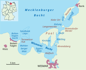
Poel
Municipality in Mecklenburg-Vorpommern, Germany
Distance: Approx. 687 meters
Latitude and longitude: 54,11.43333333
Poel (German pronunciation: [pøːl]) or Poel Island (German: Insel Poel), is an island in the Baltic Sea. It forms the natural northern and eastern boundaries of the Bay of Wismar on the German coast. The northern coast of the island is also on the south side of the large gulf known as the Bay of Mecklenburg, which Wismar Bay enters into.

Timmendorf
Ortsteil of Insel Poel in Mecklenburg-Vorpommern, Germany
Distance: Approx. 3042 meters
Latitude and longitude: 53.99055556,11.39083333
Timmendorf is part of the municipality of Insel Poel on the Baltic Sea island of the same name in the district of Nordwestmecklenburg in the German state of Mecklenburg-Vorpommern. Timmendorf lies on the west coast of the island of Poel and is divided into the villages of Timmendorf and Timmendorf Strand, which are about a kilometre from one another. A prominent landmark in Timmendorf Strand and sea mark for the navigation of shipping in the Bay of Wismar is Timmendorf Lighthouse.

Reric
Viking Age emporium on the Baltic Sea coast
Distance: Approx. 5195 meters
Latitude and longitude: 53.95555556,11.48138889
Reric or Rerik was one of the Viking Age multi-ethnic Slavic-Scandinavian emporia on the southern coast of the Baltic Sea, located near Wismar in the present-day German state of Mecklenburg-Vorpommern Reric was established probably in 735 shortly after Slavs of the Obodrite tribe had started to settle the region. At the turn of the 9th century, the citizens of Reric allied with Charlemagne, who used the port as part of a strategic trade route that would avoid areas of Saxon and Danish control. It was destroyed in 808 AD by the Viking (Danish) king Gudfred.

Walfisch
Island in Germany
Distance: Approx. 6034 meters
Latitude and longitude: 53.9403,11.4272
Walfisch is an uninhabited German island, in the Bay of Mecklenburg in the Baltic Sea. It lies approximately 4.5 kilometres (2.8 mi) north of the city of Wismar, south of the island of Poel. The island is very flat and has a maximum circumference of about 500 by 300 metres (1,640 ft × 980 ft), a surface area of 20 hectares (49 acres) and is a nature reserve.

Langenwerder
Distance: Approx. 6001 meters
Latitude and longitude: 54.03333333,11.5
Langenwerder is a small uninhabited island near the island Poel north of Gollwitz, a district of the municipality of Poel island. It is approximately 800 metres long, 500 metres wide, and flat. The island is a nature reserve, due to the birds that live there, and therefore access to the island is not usually allowed.

Bay of Wismar
Distance: Approx. 5319 meters
Latitude and longitude: 53.94888889,11.41111111
The Bay of Wismar or more commonly Wismar Bay or Wismarbucht is a well sheltered multi-sectioned bay in the southwestern Baltic Sea, in Mecklenburg-Vorpommern, Germany, and is considered the south-central part of the much larger arm of the Baltic known as the Mecklenburg Bay (or Mecklenburg Bight, for its long narrow bent shape)—a long fingerlike gulf oriented to the west-southwest (WSW) from the (central) Baltic proper. Wismar bay is considered one of the finest natural harbors on the Baltic, and served as the destination for much seaborne shipping until circa the 1910s when its minimum depths of 5 meters (16 ft) became too shallow for larger more modern ships. Today, because of the shallow sheltered waters the bay is the subject of much research via underwater archeology.

Blowatz
Municipality in Mecklenburg-Vorpommern, Germany
Distance: Approx. 6055 meters
Latitude and longitude: 53.96666667,11.51666667
Blowatz is a municipality in the Nordwestmecklenburg district, in Mecklenburg-Vorpommern, Germany.

Krusenhagen
Municipality in Mecklenburg-Vorpommern, Germany
Distance: Approx. 7175 meters
Latitude and longitude: 53.95,11.51666667
Krusenhagen is a municipality in the Nordwestmecklenburg district, in Mecklenburg-Vorpommern, Germany.
Neuburg (Amt)
Distance: Approx. 7191 meters
Latitude and longitude: 53.95,11.517
Neuburg is an Amt in the district of Nordwestmecklenburg, in Mecklenburg-Vorpommern, Germany. The seat of the Amt is in Neuburg.

Eggers Wiek
Distance: Approx. 7269 meters
Latitude and longitude: 53.94472222,11.36444444
Eggers Wiek is a sickle-shaped bay within the Bay of Wismar on the southwestern Baltic Sea coast of the German state of Mecklenburg. Its stretch of beach lies about six kilometres northwest of the Hanseatic town of Wismar and is about five kilometres long. The coast here is steep in places with sea cliffs up to 11 m above sea level (NN), but in the middle it also has flat, sandy beaches.

Breitling (Bay of Wismar)
Strait in the Baltic Sea
Distance: Approx. 3271 meters
Latitude and longitude: 53.98333333,11.48333333
The Breitling is a narrow strait in the Baltic Sea between the island of Poel and the mainland in the northeast of the district of Nordwestmecklenburg. It links the sheltered part of the Bay of Wismar, beginning south of Poeldamm, with the Salzhaff (into which estuaries of the Zaufe and Gollwitz empty). The Breitling is a very shallow body of water, mostly under one metre in depth.
Ahrendsberg
Distance: Approx. 3742 meters
Latitude and longitude: 53.966,11.468
Ahrendsberg is an uninhabited island, 8.6 hectares (21 acres) in area, near the island of Poel in the Breitling, a strait off the Bay of Wismar on the Baltic coast of Germany. The island, which is roughly 600 metres (2,000 ft) long and up to 220 metres (720 ft) wide, is dominated by salt meadows with marshy islands and shores that are dissected by creeks. The higher areas are generally very dry and are characterised by stunted vegetation, for example dry, lean grassland with thorn bushes.
Weather in this IP's area
light rain
6 Celsius
1 Celsius
5 Celsius
6 Celsius
999 hPa
92 %
999 hPa
998 hPa
8381 meters
11.75 m/s
17.34 m/s
273 degree
100 %
