Country:
 Hungary
Region:
City:
Latitude and Longitude:
Time Zone:
Postal Code:
IP information under different IP Channel
ip-api
Country
Region
City
ASN
Time Zone
ISP
Blacklist
Proxy
Latitude
Longitude
Postal
Route
IPinfo
Country
Region
City
ASN
Time Zone
ISP
Blacklist
Proxy
Latitude
Longitude
Postal
Route
MaxMind
Country
Region
City
ASN
Time Zone
ISP
Blacklist
Proxy
Latitude
Longitude
Postal
Route
Luminati
Country
HUASN
Time Zone
Europe/Budapest
ISP
Fornax ZRt.
Latitude
Longitude
Postal
db-ip
Country
Region
City
ASN
Time Zone
ISP
Blacklist
Proxy
Latitude
Longitude
Postal
Route
ipdata
Country
Region
City
ASN
Time Zone
ISP
Blacklist
Proxy
Latitude
Longitude
Postal
Route
Popular places and events near this IP address

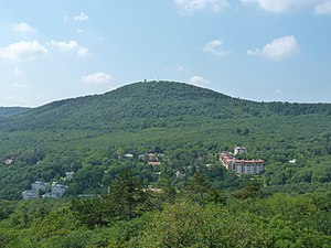
Three Border Mountain
Distance: Approx. 3750 meters
Latitude and longitude: 47.5553,18.9991
Three Border Mountain (Hungarian: Hármashatár-hegy, German: Drei·hotter·berg) is the name of a mountain in the city of Budapest, Hungary. Its name comes from the fact that the borders of three cities (Buda, Óbuda, Pesthidegkút) met at this point in the 19th century. Today, these cities have merged into Budapest, but the mountain's name has remained unchanged.

American International School of Budapest
International school in Nagykovácsi, Hungary
Distance: Approx. 4288 meters
Latitude and longitude: 47.56944444,18.9
The American International School of Budapest (or AISB) is an international school located in Nagykovácsi, Hungary, near Budapest. It was established in 1973 by the United States Embassy to serve United States Government employees' dependents; however, it now has a much more diverse student body including children of the local and expatriate business and diplomatic communities. English is the primary medium of instruction.
János-hegy
Place in Budapest, Hungary
Distance: Approx. 3651 meters
Latitude and longitude: 47.518333,18.959167
János Hill (Hungarian: János-hegy, pronounced [ˈjaːnoʃ ˈhɛɟ]) (also John's Hill) is the highest point of Budapest with a height of 528 m (1,732 ft), located in the western part of the city. From Elizabeth Lookout on the top of the hill one can get an impressive panoramic view of the whole region.
Remeteszőlős
Place in Central Hungary, Hungary
Distance: Approx. 2545 meters
Latitude and longitude: 47.56008889,18.91895
Remeteszőlős is a village in Pest county, Hungary.
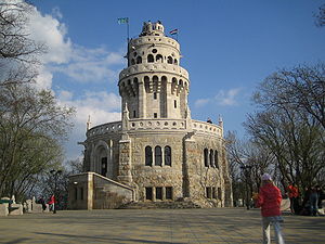
Elizabeth Lookout
Monument in
Distance: Approx. 3666 meters
Latitude and longitude: 47.51819722,18.95918333
The Elizabeth Lookout (Hungarian: Erzsébet-kilátó) is a historic lookout tower on János Hill (Hungarian: János-hegy) above Budapest. Built in 1911, the tower was named after Empress Elisabeth, wife of Emperor Franz Joseph I. Frigyes Schulek was the architect. The tower is near Budapest's District XII, and may be reached from the Széll Kálmán tér of Budapest.

International Business School, Budapest
Distance: Approx. 4464 meters
Latitude and longitude: 47.52138889,18.99055556
International Business School (Hungarian: IBS Nemzetközi Üzleti Főiskola) is an accredited private college in Budapest, Hungary. It was founded in 1991, by Prof. István Tamás.

Hárshegy
Place in Budapest, Hungary
Distance: Approx. 1926 meters
Latitude and longitude: 47.5336,18.9552
Hárshegy (English:Linden Hill, German: Lindenberg) is a part of Budapest's 2nd district. Its entire area is made up of Nagy-Hárs Hill (Great Linden Hill) and Kis-Hárs Hill (Little Linden Hill), from which there are sweeping views of Budapest. The area is a popular place for recreation, and the Hárs-hegy railway station of the Children's Railway is located in there.

Gustave Eiffel French School of Budapest
French international school in Hungary
Distance: Approx. 1553 meters
Latitude and longitude: 47.5644,18.9479
Gustave Eiffel French School of Budapest (French: Lycée Français Gustave Eiffel de Budapest, LFGEB, Hungarian: Gustave Eiffel Francia Óvoda Általános Iskola és Gimnázium), also known as the French School of Budapest (French: Lycée Français de Budapest, LFB, Hungarian: Budapesti Francia Iskola) is a French international school in Budapest, Hungary. It serves levels early childhood (maternelle) through high school (lycée).

Monastery of St Lawrence at Buda
Former religious site in Budapest, Hungary
Distance: Approx. 2693 meters
Latitude and longitude: 47.52666667,18.95583333
The Monastery of St Lawrence at Buda, also known as the Pauline Monastery of Budaszentlőrinc (Hungarian: budaszentlőrinci pálos kolostor), is a former monastery belonging to the Pauline Order. Destroyed by the Ottomans, the remains of the monastery grounds are in an area called Szépjuhászné (English: Beautiful shepherdess) which is in the saddle between Hárshegy and János Hill in the 2nd district of Budapest. It is where the Pauline Order founded their first friary.

Szépjuhászné
Place in Budapest, Hungary
Distance: Approx. 2900 meters
Latitude and longitude: 47.5247,18.955
Szépjuhászné (English: Beautiful shepherdess) ( from 1945 to 1992 Ságvári-liget ) is a small clearing in the 2nd district of Budapest, in the saddle between Hárshegy and János-hegy.

Bathory Cave
Cave in Budapest
Distance: Approx. 1936 meters
Latitude and longitude: 47.53361111,18.95583333
The Bathory Cave (Hungarian: Bátori-barlang) is a cave located just below the top of Nagy-Hárs Hill (Great Linden Hill), on the northeast side of the mountain. It is located within the Danube-Ipoly National Park and the 2nd district of Budapest. The cave gets its name from Pauline monk, László Báthory who used the cave as a hermitage for twenty years.

Hűvösvölgy
Neighbourhood in 2nd District, Budapest, Hungary
Distance: Approx. 1486 meters
Latitude and longitude: 47.540833,18.963333
Hűvösvölgy is a neighbourhood in the 2nd District of Budapest. The area is a popular hiking destination and is also an important transport hub. The suburb is known for its terminus of the Budapest Children's Railway.
Weather in this IP's area
scattered clouds
9 Celsius
8 Celsius
8 Celsius
10 Celsius
1023 hPa
70 %
1023 hPa
995 hPa
10000 meters
2.04 m/s
4.17 m/s
75 degree
47 %
07:07:23
17:50:53