Country:
 Switzerland
Region:
City:
Latitude and Longitude:
Time Zone:
Postal Code:
IP information under different IP Channel
ip-api
Country
Region
City
ASN
Time Zone
ISP
Blacklist
Proxy
Latitude
Longitude
Postal
Route
IPinfo
Country
Region
City
ASN
Time Zone
ISP
Blacklist
Proxy
Latitude
Longitude
Postal
Route
MaxMind
Country
Region
City
ASN
Time Zone
ISP
Blacklist
Proxy
Latitude
Longitude
Postal
Route
Luminati
Country
CHRegion
tg
City
dussnang
ASN
Time Zone
Europe/Zurich
ISP
LeuPuls AG
Latitude
Longitude
Postal
db-ip
Country
Region
City
ASN
Time Zone
ISP
Blacklist
Proxy
Latitude
Longitude
Postal
Route
ipdata
Country
Region
City
ASN
Time Zone
ISP
Blacklist
Proxy
Latitude
Longitude
Postal
Route
Popular places and events near this IP address

Fischingen Abbey
Distance: Approx. 2382 meters
Latitude and longitude: 47.411927,8.968282
Fischingen Abbey (Kloster Fischingen), now Fischingen Priory, is a Benedictine monastery situated in Fischingen in the Canton of Thurgau, Switzerland, on the upper reaches of the Murg, a tributary of the Thur. It was founded in 1138, dissolved in 1848 and re-founded as a priory in 1977.

Bichelsee-Balterswil
Municipality in Thurgau, Switzerland
Distance: Approx. 3417 meters
Latitude and longitude: 47.45,8.91666667
Bichelsee-Balterswil is a municipality in the district of Münchwilen in the canton of Thurgau in Switzerland. It was formed from the union on January 1, 1996 of Bichelsee and Balterswil.

Eschlikon
Municipality in Thurgau, Switzerland
Distance: Approx. 2792 meters
Latitude and longitude: 47.45,8.95
Eschlikon is a municipality in the district of Münchwilen in the canton of Thurgau in Switzerland.

Fischingen
Municipality in Thurgau, Switzerland
Distance: Approx. 1985 meters
Latitude and longitude: 47.41666667,8.96666667
Fischingen is a municipality in the district of Münchwilen in the canton of Thurgau in Switzerland.

Sternenberg
Former municipality in Zurich, Switzerland
Distance: Approx. 5093 meters
Latitude and longitude: 47.38333333,8.91666667
Sternenberg is a former municipality in the district of Pfäffikon in the canton of Zürich in Switzerland. Bauma and Sternenberg merged to Bauma on 1 January 2015.
Bichelsee
Village in the canton of Thurgau, Switzerland
Distance: Approx. 2856 meters
Latitude and longitude: 47.45,8.93333333
Bichelsee is a village and former municipality in the canton of Thurgau, Switzerland. It takes its name from the nearby lake, Bichelsee. The municipality also contained the villages Höfli, Niederhofen am Bichelsee and Itaslen.

Balterswil
Swiss village in the canton of Thurgau
Distance: Approx. 3093 meters
Latitude and longitude: 47.45277778,8.9375
Balterswil is a village and former municipality in the canton of Thurgau, Switzerland. The municipality also contained the villages Lützelmurg, Zielwies, Ifwil and Lochwies.

Bichelsee (lake)
Lake in the canton of Thurgau, Switzerland
Distance: Approx. 4846 meters
Latitude and longitude: 47.4575,8.90027778
Bichelsee is a lake in the canton of Thurgau, Switzerland. The village of Bichelsee in the municipality Bichelsee-Balterswil is named after the lake. Of the surface of 0.092 km², 5/6 are located in the canton of Thurgau, the remainder in the canton of Zurich.
Hohgrat
Mountain in Switzerland
Distance: Approx. 4753 meters
Latitude and longitude: 47.38541667,8.96611111
The Hohgrat (also known as Groot) is a mountain located on the border between the Swiss cantons of Thurgau and St. Gallen. Reaching a height of 996 metres above sea level, it is the highest point of the canton of Thurgau.

Tannegg Castle
Distance: Approx. 772 meters
Latitude and longitude: 47.430423,8.950518
Tannegg Castle is a castle in the municipality of Fischingen of the Canton of Thurgau in Switzerland. It is a Swiss heritage site of national significance.

Alt-Bichelsee Castle
Distance: Approx. 3151 meters
Latitude and longitude: 47.447358,8.917382
Alt-Bichelsee Castle is a ruined castle in the Swiss Canton of Thurgau in the municipality of Bichelsee-Balterswil.
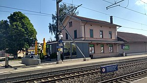
Eschlikon railway station
Swiss railway station
Distance: Approx. 4183 meters
Latitude and longitude: 47.46149111,8.95853611
Eschlikon railway station (German: Bahnhof Eschlikon) is a railway station in the municipality of Eschlikon, in the Swiss canton of Thurgau. It is an intermediate stop on the standard gauge St. Gallen–Winterthur line of Swiss Federal Railways.
Weather in this IP's area
moderate rain
11 Celsius
11 Celsius
10 Celsius
13 Celsius
1015 hPa
86 %
1015 hPa
936 hPa
10000 meters
1.02 m/s
1.67 m/s
248 degree
100 %
07:44:22
18:34:44