193.242.141.100 - IP Lookup: Free IP Address Lookup, Postal Code Lookup, IP Location Lookup, IP ASN, Public IP
Country:
 Croatia
Region:
City:
Location:
Time Zone:
Postal Code:
ISP:
ASN:
language:
User-Agent:
Proxy IP:
Blacklist:
IP information under different IP Channel
ip-api
Country
Region
City
ASN
Time Zone
ISP
Blacklist
Proxy
Latitude
Longitude
Postal
Route
db-ip
Country
Region
City
ASN
Time Zone
ISP
Blacklist
Proxy
Latitude
Longitude
Postal
Route
IPinfo
Country
Region
City
ASN
Time Zone
ISP
Blacklist
Proxy
Latitude
Longitude
Postal
Route
IP2Location
193.242.141.100Country
hrRegion
splitsko-dalmatinska zupanija
City
trogir
Time Zone
Europe/Zagreb
ISP
Language
User-Agent
Latitude
Longitude
Postal
ipdata
Country
Region
City
ASN
Time Zone
ISP
Blacklist
Proxy
Latitude
Longitude
Postal
Route
Popular places and events near this IP address

Trogir
Town in Split-Dalmatia, Croatia
Distance: Approx. 491 meters
Latitude and longitude: 43.51690278,16.25136389
Trogir (Croatian pronunciation: [ˈtrɔ.ɡiːr]; Latin: Tragurium; Ancient Greek: Τραγύριον, Tragyrion or Τραγούριον, Tragourion), historically known as Traù (from Dalmatian, Venetian and Italian: pronounced [traˈu]) is a historic town and harbour on the Adriatic coast in Split-Dalmatia County, Croatia, with a population of 10,923 (2011) and a total municipal population of 13,192 (2011). The historic city of Trogir is situated on a small island between the Croatian mainland and the island of Čiovo. It lies 27 kilometres (17 miles) west of the city of Split.

Čiovo
Island off the coast of Croatia
Distance: Approx. 2909 meters
Latitude and longitude: 43.5,16.28333333
Čiovo (pronounced [tʃîɔv̞ɔ]) is an island located off the Adriatic coast in Croatia with an area of 28.8 square kilometres (11.1 sq mi) (length 15.3 km (9.5 mi), width up to 3.5 km (2.2 mi)), population of 5,908 inhabitants (2011). Its highest peak is the 218 m Rudine. The centre of the island has geographical coordinates of 43°30′N 16°17′E, and the annual rainfall is about 900 mm (35 in).

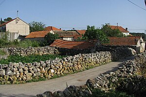
Okrug, Croatia
Municipality in Split-Dalmatia County, Croatia
Distance: Approx. 3090 meters
Latitude and longitude: 43.49694444,16.22
Okrug is a municipality in Croatia in the Split-Dalmatia County. In the 2011 census, it had a total population of 3,349, in the following settlements: Okrug Donji, population 268 Okrug Gornji, population 3,081 In the same census, 95% were Croats.

Seget, Croatia
Municipality in Split-Dalmatia, Croatia
Distance: Approx. 1557 meters
Latitude and longitude: 43.5167,16.2333
Seget is a municipality in Croatia in the Split-Dalmatia County. In the 2011 census, it had a total population of 4,854, in the following settlements: Bristivica, population 348 Ljubitovica, population 485 Prapatnica, population 177 Seget Donji, population 2,681 Seget Gornji, population 136 Seget Vranjica, population 1,027 In the 2011 census, 97.4% of the population were Croats.

Trogir Cathedral
Roman Catholic basilica in Trogir, Croatia
Distance: Approx. 511 meters
Latitude and longitude: 43.51708333,16.25138889
The Cathedral of St. Lawrence (Croatian: Katedrala Sv. Lovre, Italian: Cattedrale di San Lorenzo) is a Roman Catholic triple-naved basilica constructed in Romanesque-Gothic in Trogir, Croatia.

Kamerlengo Castle
Fortification in Croatia
Distance: Approx. 459 meters
Latitude and longitude: 43.51527778,16.2475
Kamerlengo Castle (Croatian: Kaštel Kamerlengo; Italian: Castello del Camerlengo) is a castle and fortress in Trogir, Croatia.
Žedno
Place in Split-Dalmatia, Croatia
Distance: Approx. 2596 meters
Latitude and longitude: 43.51666667,16.28333333
Žedno is a village in the Čiovo island, near Split, Croatia. It is situated on the top of Čiovo island. The village has a church and a kindergarten, but no school.

Okrug Gornji
Place in Split-Dalmatia, Croatia
Distance: Approx. 2268 meters
Latitude and longitude: 43.49475,16.2655
Okrug Gornji is a village in the municipality of Okrug, Croatia, located on the western side of the island of Čiovo. Okrug Gornji (lit. 'Upper Okrug') is a traditional Dalmatian village, paired with Okrug Donji (lit. 'Lower Okrug'). Newly built holiday homes and hotels along the island's coast have linked Trogir and Okrug Gornji into a continuous urban and suburban area.

Bijaći
Village in Croatia
Distance: Approx. 4258 meters
Latitude and longitude: 43.5408,16.2872
Bijaći (Italian: Santa Marta) is a village in Croatia, 5 kilometres (3.1 mi) northeast of Trogir, at the contact point between the Trogir part and the Lower Kaštela part of the Velo field. It was first mentioned in two old Croatian documents from AD 852 (Byaci) and AD 892 (Biaci). At the locality of Stombrate are the remains of an early Croatian church of St.

Mastrinka
Village in Croatia
Distance: Approx. 2846 meters
Latitude and longitude: 43.51194444,16.28694444
Mastrinka is a village on the island of Čiovo in Croatia. It is connected by the D126 highway.

Igralište Batarija
Football stadium in Trogir, Croatia
Distance: Approx. 534 meters
Latitude and longitude: 43.51583333,16.24694444
Batarija is a football stadium located in Trogir, Croatia.
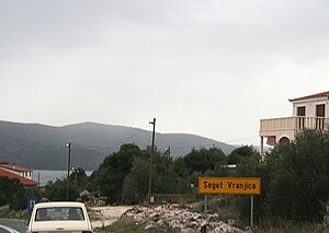
Seget Vranjica
Village in Split-Dalmatia, Croatia
Distance: Approx. 5693 meters
Latitude and longitude: 43.5,16.18333333
Seget Vranjica is a village in the Split-Dalmatia County of Croatia. It is located on the Adriatic coast of Dalmatia, about 6 km west of Trogir, population 1,027 (2011). It is a tourist destination.
Weather in this IP's area
clear sky
11 Celsius
10 Celsius
11 Celsius
11 Celsius
1026 hPa
66 %
1026 hPa
1013 hPa
10000 meters