Country:
 Germany
Region:
City:
Latitude and Longitude:
Time Zone:
Postal Code:
IP information under different IP Channel
ip-api
Country
Region
City
ASN
Time Zone
ISP
Blacklist
Proxy
Latitude
Longitude
Postal
Route
IPinfo
Country
Region
City
ASN
Time Zone
ISP
Blacklist
Proxy
Latitude
Longitude
Postal
Route
MaxMind
Country
Region
City
ASN
Time Zone
ISP
Blacklist
Proxy
Latitude
Longitude
Postal
Route
Luminati
Country
DEASN
Time Zone
Europe/Berlin
ISP
Amadeus Data Processing GmbH
Latitude
Longitude
Postal
db-ip
Country
Region
City
ASN
Time Zone
ISP
Blacklist
Proxy
Latitude
Longitude
Postal
Route
ipdata
Country
Region
City
ASN
Time Zone
ISP
Blacklist
Proxy
Latitude
Longitude
Postal
Route
Popular places and events near this IP address

Bad Homburg
Town in Hesse, Germany
Distance: Approx. 1622 meters
Latitude and longitude: 50.21666667,8.6
Bad Homburg vor der Höhe (German pronunciation: [baːt ˈhɔmbʊʁk] ) is the district town of the Hochtaunuskreis, Hesse, Germany, on the southern slope of the Taunus mountains. Bad Homburg is part of the Frankfurt Rhein-Main urban area. The town's official name is Bad Homburg v.d.Höhe, which distinguishes it from other places named Homburg.

Church of the Redeemer, Bad Homburg
Church in Bad Homburg, Germany
Distance: Approx. 826 meters
Latitude and longitude: 50.22638889,8.61166667
The Church of the Redeemer (German: Erlöserkirche) of Bad Homburg belongs to the Protestant Church in Germany. Finished in 1908, the building is outwardly of a heavy, Romanesque Revival appearance, while its interior is in a neo-Byzantine style, with rich marble wall decorations and gold mosaics covering the domed ceiling, leading to the church sometimes being called 'Bad Homburg's Hagia Sophia'.
Kaiserin-Friedrich-Gymnasium
Public school in Hesse, Germany
Distance: Approx. 1107 meters
Latitude and longitude: 50.225,8.636
The Kaiserin-Friedrich-Gymnasium (abbreviation: KFG; Empress Frederick Gymnasium) is a secondary school in Bad Homburg vor der Höhe, Hesse, Germany.
Humboldtschule, Bad Homburg
Public school in Hesse, Germany
Distance: Approx. 793 meters
Latitude and longitude: 50.222,8.61
The Humboldtschule (abbreviation: HUS; English: Humboldt School) is one of two Gymnasiums, besides the Kaiserin-Friedrich-Gymnasium (KFG), in Bad Homburg vor der Höhe, Hesse, Germany. The eponyms are Alexander (1769–1859) and Wilhelm von Humboldt (1767–1835). Since November 2000 the school is a recognized UNESCO project school (UNESCO-Projektschule).

Maria-Ward-Schule, Bad Homburg
Private school in Hesse, Germany
Distance: Approx. 987 meters
Latitude and longitude: 50.22897222,8.62988333
The Maria-Ward-Schule (abbreviation: MWS; English: Maria Ward School) is a private school for girls in Bad Homburg vor der Höhe, Hesse, Germany. The eponym is Mary Ward (1585–1645). The school has approximate 28 teachers and 400 students.
Gesamtschule am Gluckenstein
Public school in Hesse, Germany
Distance: Approx. 2663 meters
Latitude and longitude: 50.24038056,8.59701944
The Gesamtschule am Gluckenstein (abbreviation: GaG; English: Comprehensive school at the Gluckenstein) is a Gesamtschule (comprehensive school) in Bad Homberg vor der Höhe, Hesse, Germany. The school has approximate 70 teachers and more than 800 students. In school year 2006/2007 the school time at the Gymnasium at the Gesamtschule am Gluckenstein was reduced from nine to eight years.
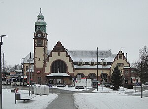
Bad Homburg station
Railway station in Bad Homburg vor der Höhe, Germany
Distance: Approx. 234 meters
Latitude and longitude: 50.22,8.62111111
Bad Homburg station is located in Bad Homburg, Hesse, Germany on the Homburg Railway and was opened on 26 October 1907. It is used by about 19,000 passengers each day.

Dornbach (Eschbach)
River in Hesse, Germany
Distance: Approx. 409 meters
Latitude and longitude: 50.2208,8.6265
Dornbach (in its upper course: Kaltes Wasser) is a river of Hesse, Germany. It flows into the Eschbach in Bad Homburg vor der Höhe.

Bad Homburg Castle
Distance: Approx. 1022 meters
Latitude and longitude: 50.2279,8.61
Bad Homburg Castle (Schloss Bad Homburg) or Homburg Palace is a castle and palace in the German city of Bad Homburg vor der Höhe. Originally the residence of the Landgraves of Hesse-Homburg, it was first built in the 12th century. All but the keep was demolished in 1660 by Frederick II, Landgrave of Hesse-Homburg.

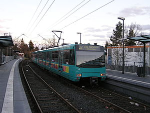
Seulberg station
Railway station in Friedrichsdorf, Germany
Distance: Approx. 2831 meters
Latitude and longitude: 50.24214,8.64561
Seulberg station is a railway station in the Seulberg district in the municipality of Friedrichsdorf, located in the Hochtaunuskreis district in Hesse, Germany.
Bad Homburg Gonzenheim (Frankfurt U-Bahn)
Station on line U2 of the Frankfurt U-Bahn, Germany
Distance: Approx. 1429 meters
Latitude and longitude: 50.219,8.6406
Bad Homburg Gonzenheim is a station on line U2 of the Frankfurt U-Bahn. It is located in the Gonzenheim district of Bad Homburg vor der Höhe, in Hesse, Germany. Known for its spacious platform.

St. Mary's Church, Bad Homburg
Distance: Approx. 688 meters
Latitude and longitude: 50.226,8.61363889
St. Mary's Church (German: Marienkirche) (also St. Marien) is the principal Roman Catholic parish church in Bad Homburg, Hesse, Germany.
Weather in this IP's area
overcast clouds
14 Celsius
13 Celsius
13 Celsius
15 Celsius
1014 hPa
85 %
1014 hPa
994 hPa
10000 meters
1 m/s
1.94 m/s
83 degree
100 %
07:52:47
18:28:06