Country:
Region:
City:
Latitude and Longitude:
Time Zone:
Postal Code:
IP information under different IP Channel
ip-api
Country
Region
City
ASN
Time Zone
ISP
Blacklist
Proxy
Latitude
Longitude
Postal
Route
Luminati
Country
ASN
Time Zone
Europe/Moscow
ISP
DpkgSoft International Limited
Latitude
Longitude
Postal
IPinfo
Country
Region
City
ASN
Time Zone
ISP
Blacklist
Proxy
Latitude
Longitude
Postal
Route
db-ip
Country
Region
City
ASN
Time Zone
ISP
Blacklist
Proxy
Latitude
Longitude
Postal
Route
ipdata
Country
Region
City
ASN
Time Zone
ISP
Blacklist
Proxy
Latitude
Longitude
Postal
Route
Popular places and events near this IP address

Grand Duchy of Frankfurt
State
Distance: Approx. 242 meters
Latitude and longitude: 50.11666667,8.68333333
The Grand Duchy of Frankfurt was a German satellite state of Napoleonic creation. It came into existence in 1810 through the combination of the former territories of the Archbishopric of Mainz along with the Free City of Frankfurt itself.

Confederation of the Rhine
Napoleonic union of German client states
Distance: Approx. 242 meters
Latitude and longitude: 50.11666667,8.68333333
The Confederated States of the Rhine, simply known as the Confederation of the Rhine or Rhine Confederation, was a confederation of German client states established at the behest of Napoleon some months after he defeated Austria and Russia at the Battle of Austerlitz. Its creation brought about the dissolution of the Holy Roman Empire shortly afterward. The Confederation of the Rhine lasted for only seven years, from 1806 to 1813, dissolving after Napoleon's defeat in the War of the Sixth Coalition.

Deutsche Börse
Financial services company of Germany
Distance: Approx. 189 meters
Latitude and longitude: 50.115,8.678
Deutsche Börse AG (German pronunciation: [ˈdɔʏtʃə ˈbœʁzə]), or the Deutsche Börse Group, is a German multinational corporation that offers a marketplace for organizing the trading of shares and other securities. It is also a transaction services provider, giving companies and investors access to global capital markets. It is a joint stock company and was founded in 1992, with headquarters in Frankfurt.

Zeilgalerie
Distance: Approx. 142 meters
Latitude and longitude: 50.11416667,8.68111111
Zeilgalerie was a shopping centre located at the Zeil in Frankfurt am Main, Germany. It was opened in September 1992 and was 41 metres tall with 10 floors, one of which was underground. There were approximately 70 stores in the building.
Zeil
Shopping street in Frankfurt, Germany
Distance: Approx. 241 meters
Latitude and longitude: 50.11444444,8.68361111
The Zeil (German: [ˈtsaɪl]) is a street in the city centre of Frankfurt, Germany. The name, which dates back to the 14th century, is derived from the German word Zeile "row" and originally referred to a row of houses on the eastern end of the north side; the name was not extended to the entire street until later. Since the end of the 19th century it has been one of the most famous and busiest shopping streets in Germany.

Palais Quartier
Building complex in the Innenstadt district of Frankfurt, Germany
Distance: Approx. 97 meters
Latitude and longitude: 50.1147,8.68139
The Palais Quartier (German: [paˈleː kvaʁˌtiːɐ̯]), formerly known as FrankfurtHochVier, is a building complex in the Innenstadt district of Frankfurt, Germany. It was built from 2004 to 2011. The complex consists of four buildings: MyZeil, a shopping mall with a gross leaseable area of 77,000 sq m Palais Thurn und Taxis, a reconstruction of a palace from 1793 which had been badly damaged in World War II Nextower, a 136-meter (446 ft)-high rise office building with a floor area of 48,000 sq m JW Marriott Frankfurt (Jumeirah Frankfurt until April 2022), a 99-meter (325 ft)-high rise hotel building with 271 units Beneath the complex lies the largest underground car park in Frankfurt's city centre with 1,396 parking positions.

MyZeil
Shopping mall in central Frankfurt, Germany
Distance: Approx. 158 meters
Latitude and longitude: 50.11416667,8.68166667
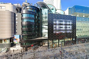
MyZeil is a shopping mall in the center of Frankfurt, Germany. It was designed by Italian architect Massimiliano Fuksas. It is part of the PalaisQuartier development, with its main entrance on the Zeil, Frankfurt's main shopping street.
Eschenheimer Turm
Landmark of Frankfurt
Distance: Approx. 178 meters
Latitude and longitude: 50.1169,8.67972
Eschenheimer Turm (Eschenheim Tower) was a city gate, part of the late-medieval fortifications of Frankfurt am Main, and is a landmark of the city. The tower, which was erected at the beginning of the fifteenth century, is at once the oldest and most unaltered building in the largely reconstructed Frankfurter Neustadt (new town), now better known as the Innenstadt (city center).

Palais Thurn und Taxis
Reconstructed historic building in Frankfurt am Main
Distance: Approx. 76 meters
Latitude and longitude: 50.115,8.67972
The Palais Thurn und Taxis (German: [paˈleː ˈtuːɐ̯n ʔʊnt ˈtaksɪs]) in Frankfurt, Germany was built from 1731 to 1739 by Robert de Cotte and commissioned by the Imperial Postmaster, Prince Anselm Franz von Thurn und Taxis (1714–1739). The building was heavily damaged in World War II and then demolished. Today a reconstruction houses some shops.

Frankfurt Hauptwache station
Railway station in Frankfurt, Germany
Distance: Approx. 207 meters
Latitude and longitude: 50.11388889,8.67888889
Frankfurt (Main) Hauptwache station (German: Bahnhof Frankfurt (Main) Hauptwache) is a major train station situated at the Hauptwache square in the centre of Frankfurt, Germany. As of 2022, with 93,000 passengers per day, Hauptwache station is the third-busiest rapid transit station in Frankfurt after Frankfurt Central Station and Konstablerwache station and a major hub for commuter transport in the Frankfurt/Rhine-Main region. It is served by eight S-Bahn lines (S1–S6, S8, S9) and six U-Bahn lines (U1–U3, U6–U8) on 2 levels.

Bizonal Economic Council
Legislative body in occupied Germany
Distance: Approx. 199 meters
Latitude and longitude: 50.1153,8.6778
The Wirtschaftsrat or Economic Council was West Germany's first post-war legislative parliament and progenitor of the German Bundestag. After the American Secretary of State George C. Marshall pushed for organisational improvements in the Anglo-American zone of occupation in post-war West Germany, the two Military Governors Lucius D. Clay and Sir Brian Robertson signed the ‘Agreement for Reorganisation of Bizonal Economic Agencies’ on 29 May 1947 resulting in the creation of the so-called Wirtschaftsrat (Economic Council), which became effective on 10 June 1947. In principle, the Economic Council consisted of three organs concentrated in Frankfurt am Main: the Exekutivrat (Executive Committee) as a second chamber with representatives of the eight Länder in the Bizone, the Direktoren der Verwaltung (Executive Directors) as quasi-ministers presiding over the five already existing administrations, and, finally, the actual Wirtschaftsrat as first post-war parliament.
DSK Hyp
German subsidiary of Skandinaviska Enskilda Banken
Distance: Approx. 187 meters
Latitude and longitude: 50.116705,8.682235
DSK Deutsch-Skandinavische Verwaltungs AG (formerly SEB AG and DSK Hyp AG) is the German subsidiary of one of the largest Swedish banks, the Skandinaviska Enskilda Banken (SEB).
Weather in this IP's area
overcast clouds
7 Celsius
7 Celsius
7 Celsius
9 Celsius
1026 hPa
94 %
1026 hPa
1012 hPa
10000 meters
1.03 m/s
100 %
07:39:00
16:41:05

