Country:
 Romania
Region:
City:
Latitude and Longitude:
Time Zone:
Postal Code:
IP information under different IP Channel
ip-api
Country
Region
City
ASN
Time Zone
ISP
Blacklist
Proxy
Latitude
Longitude
Postal
Route
IPinfo
Country
Region
City
ASN
Time Zone
ISP
Blacklist
Proxy
Latitude
Longitude
Postal
Route
MaxMind
Country
Region
City
ASN
Time Zone
ISP
Blacklist
Proxy
Latitude
Longitude
Postal
Route
Luminati
Country
ROASN
Time Zone
Europe/Bucharest
ISP
Universitatea de Medicina si Farmacie Victor Babes Timisoara
Latitude
Longitude
Postal
db-ip
Country
Region
City
ASN
Time Zone
ISP
Blacklist
Proxy
Latitude
Longitude
Postal
Route
ipdata
Country
Region
City
ASN
Time Zone
ISP
Blacklist
Proxy
Latitude
Longitude
Postal
Route
Popular places and events near this IP address

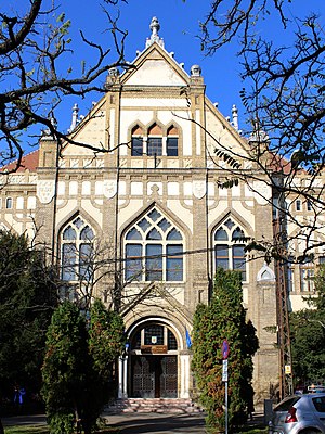
Victor Babeș University of Medicine and Pharmacy of Timișoara
Distance: Approx. 31 meters
Latitude and longitude: 45.75694444,21.23666667
Victor Babeș University of Medicine and Pharmacy of Timișoara (Romanian: Universitatea de Medicină și Farmacie „Victor Babeș” din Timișoara; abbreviated UMFT) is a state university in Timișoara. The university was founded on 30 December 1944 by decree of the then King of Romania Michael I. There are three faculties within UMFT: Medicine, Dentistry and Pharmacy. In 2011, UMFT was classified as an education and research university by the Ministry of Education.

Theresia Bastion
Bastion in Timișoara, Romania
Distance: Approx. 232 meters
Latitude and longitude: 45.75666667,21.23361111
Theresia Bastion (Romanian: Bastionul Theresia), named after the Austrian Empress Maria Theresa, is the largest preserved piece of defensive wall of the Austrian-Hungarian fortress of Timișoara. It covers about 1.7 hectares of the city center. It was built between 1732 and 1734.

Fountain of Cardinal Points
Distance: Approx. 296 meters
Latitude and longitude: 45.75777778,21.23277778
Fountain of Cardinal Points is one of the representative fountains of Timișoara, being located near Ion I.C. Brătianu Square, at the intersection of Oituz Street and Take Ionescu Boulevard.
Ana Aslan National College (Timișoara)
High school, post-secondary school
Distance: Approx. 169 meters
Latitude and longitude: 45.75583333,21.23555556
Ana Aslan National College is a high school in Timișoara named after Romanian gerontologist Ana Aslan. It also features a post-secondary school that educates students in the field of nursing.
Carmen Sylva National Pedagogical College
Pedagogical high school
Distance: Approx. 351 meters
Latitude and longitude: 45.75416667,21.23527778
Carmen Sylva National Pedagogical College is a high school with pedagogical profile in Timișoara, named after Queen Elisabeth of Romania, patroness of the arts bearing the pseudonym Carmen Sylva. The college operates with 43 classrooms, four laboratories, a library with over 50,000 volumes, boarding school and canteen.

Lutheran Church, Timișoara
Distance: Approx. 402 meters
Latitude and longitude: 45.75777778,21.23138889
The Lutheran Church (Romanian: Biserica Luterană; German: Lutherkirche) is a Lutheran church in the Cetate district of Timișoara. It is the only Lutheran church in Timișoara, the Lutheran community here numbering about 400 people and being composed of Germans, Hungarians, Slovaks and Romanians. The religious service is officiated in all four languages.

Count Mercy House
Building in Timișoara, Romania
Distance: Approx. 394 meters
Latitude and longitude: 45.75611111,21.23166667
The Count Mercy House (Romanian: Casa Contelui de Mercy) is a historical monument in Timișoara, Romania. Also known as Mercy Palace, it was the residence of Florimond de Mercy d'Argenteau, former governor of Banat. Over time, the building was also the residence of the Roman Catholic bishop and a prison, and nowadays it houses offices and commercial spaces.

Deschan Palace
Building in Timișoara, Romania
Distance: Approx. 436 meters
Latitude and longitude: 45.75611111,21.23111111
The Deschan Palace (Romanianized as Dejan), also known as the Scherter House, is a historic building in Timișoara, Romania, built in 1735 in the neoclassical style. The building hosted the first bazaar and the first casino in Timișoara.

Dicasterial Palace
Building in Timișoara, Romania
Distance: Approx. 401 meters
Latitude and longitude: 45.75666667,21.23138889
The Dicasterial Palace (Romanian: Palatul Dicasterial) is a historical monument in Timișoara, Romania, which serves today as the headquarters of the local court, tribunal and court of appeal.
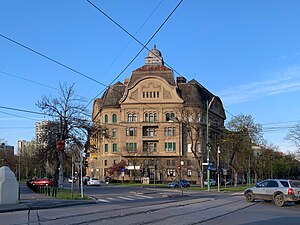
Neptune Public Bath
Building in Timișoara, Romania
Distance: Approx. 430 meters
Latitude and longitude: 45.75664444,21.24198333
The Neptune Public Bath (Romanian: Baia Publică Neptun or Băile Neptun), also known as the Neptune Palace (Romanian: Palatul Neptun), is a historic building in the Fabric district of Timișoara, Romania. Originally a spa, today the building hosts office spaces, a luxury restaurant and around 20 apartments in the so-called Bloc Neptun.
Ion I. C. Brătianu Square
Square in Timișoara, Romania
Distance: Approx. 296 meters
Latitude and longitude: 45.75777778,21.23277778
Ion I. C. Brătianu Square, formerly known as Dr. N. Russel Square, is an urban square in the Cetate district of Timișoara, Romania. It is named after the former Romanian prime minister Ion I. C. Brătianu (1864–1927).

House with Iron Axle
Building in Ion I. C. Brătianu Square, Timișoara
Distance: Approx. 398 meters
Latitude and longitude: 45.7575,21.23138889
The House with Iron Axle (Romanian: Casa cu Axă de Fier) is a historical house, listed as a historical monument, in the Cetate district of Timișoara. It consists of two bodies, a 2.5-meter axle being mounted on the corner of the eastern body, hence the name.
Weather in this IP's area
clear sky
24 Celsius
24 Celsius
24 Celsius
25 Celsius
1015 hPa
46 %
1015 hPa
1005 hPa
10000 meters
3.6 m/s
90 degree
07:02:40
20:04:24