Country:
 Germany
Region:
City:
Latitude and Longitude:
Time Zone:
Postal Code:
IP information under different IP Channel
ip-api
Country
Region
City
ASN
Time Zone
ISP
Blacklist
Proxy
Latitude
Longitude
Postal
Route
IPinfo
Country
Region
City
ASN
Time Zone
ISP
Blacklist
Proxy
Latitude
Longitude
Postal
Route
MaxMind
Country
Region
City
ASN
Time Zone
ISP
Blacklist
Proxy
Latitude
Longitude
Postal
Route
Luminati
Country
DEASN
Time Zone
Europe/Berlin
ISP
Vodafone GmbH
Latitude
Longitude
Postal
db-ip
Country
Region
City
ASN
Time Zone
ISP
Blacklist
Proxy
Latitude
Longitude
Postal
Route
ipdata
Country
Region
City
ASN
Time Zone
ISP
Blacklist
Proxy
Latitude
Longitude
Postal
Route
Popular places and events near this IP address
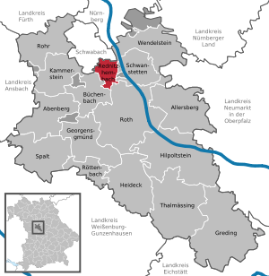
Roth (district)
District in Bavaria, Germany
Distance: Approx. 3689 meters
Latitude and longitude: 49.25,11.08
Roth is a Landkreis (district) in Middle Franconia, Bavaria, Germany. It is bounded by (from the northeast and clockwise) the districts of Nürnberger Land, Neumarkt, Eichstätt, Weißenburg-Gunzenhausen, Ansbach and Fürth, and the cities of Schwabach and Nürnberg. In medieval times the area was ruled by many lords.

Schwabach
Town in Bavaria, Germany
Distance: Approx. 6441 meters
Latitude and longitude: 49.32916667,11.02083333
Schwabach (German pronunciation: [ˈʃvaːbax] ) is a German city of about 40,000 inhabitants near Nuremberg in the centre of the region of Franconia in the north of Bavaria. Together with the neighboring cities of Nuremberg, Fürth and Erlangen, Schwabach forms one of the three metropolitan areas in Bavaria. The city is an autonomous administrative district (kreisfreie Stadt).

Roth, Bavaria
Town in Bavaria, Germany
Distance: Approx. 4574 meters
Latitude and longitude: 49.24611111,11.09111111
Roth (formerly Roth bei Nürnberg) is a town in Bavaria, Germany, the capital of the Roth District. It is located about 25 km south of Nuremberg.

Abenberg
Town in Bavaria, Germany
Distance: Approx. 6181 meters
Latitude and longitude: 49.25,10.96666667
Abenberg (German: [ˈaːbm̩bɛʁk] ) is a town in the Middle Franconian district of Roth, in Bavaria, Germany. It is situated 9 km west of Roth bei Nürnberg and 25 km southwest of Nuremberg.

Büchenbach
Municipality in Bavaria, Germany
Distance: Approx. 1811 meters
Latitude and longitude: 49.26666667,11.06666667
Büchenbach is a municipality in the district of Roth, in Bavaria, Germany.

Kammerstein
Municipality in Bavaria, Germany
Distance: Approx. 5719 meters
Latitude and longitude: 49.28333333,10.96666667
Kammerstein is a municipality in the district of Roth in Bavaria in Germany.
Rednitzhembach
Municipality in Bavaria, Germany
Distance: Approx. 4042 meters
Latitude and longitude: 49.30527778,11.07027778
Rednitzhembach is municipality in the district of Roth in Bavaria in Germany. It is located 18 kilometers south of the Nuremberg-Fürth city axis, five kilometers southeast of Schwabach and six kilometers north of Roth.

Aurach (Rednitz)
River in Germany
Distance: Approx. 3439 meters
Latitude and longitude: 49.2542,11.0811
Aurach (German pronunciation: [ˈaʊ̯ʁax] ) is a river in the Bavarian Landkreise (districts) of Ansbach and Roth, Germany. The name means "river, where the Aurochs' graze" (Old High German ūr = Auerochs and aha = flowing water). The Aurach originates about 1 kilometre (0.6 mi) west of Petersaurach, Middle Franconia at an altitude of 452 metres (1,483 ft) above sea level.

Roth (Rednitz)
River in Germany
Distance: Approx. 4215 meters
Latitude and longitude: 49.2481,11.0872
Roth is a river of Bavaria, Germany. It is a right tributary of the Rednitz in the town Roth.
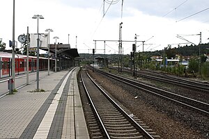
Roth station
Railway station in Roth, Germany
Distance: Approx. 4556 meters
Latitude and longitude: 49.24114,11.08268806
Roth station is a railway station in the municipality of Roth, located in the Roth district in Middle Franconia, Germany. The station is located at the junction of the Nuremberg–Roth, Nuremberg–Augsburg, and Roth–Greding lines.
Lohgarten-Roth station
Railway station in Roth, Germany
Distance: Approx. 5026 meters
Latitude and longitude: 49.2436,11.096
Lohgarten-Roth station is a railway station in the Lohgarten district of the municipality of Roth, located in the Roth district in Middle Franconia, Germany.

Schwabach station
Railway station in Schwabach, Germany
Distance: Approx. 5875 meters
Latitude and longitude: 49.32577389,11.03527389
Schwabach station is a railway station in the municipality of Schwabach, located in Middle Franconia, Germany. The station is on the Nuremberg–Augsburg and Nuremberg–Roth lines of Deutsche Bahn.
Weather in this IP's area
clear sky
21 Celsius
20 Celsius
20 Celsius
21 Celsius
1019 hPa
61 %
1019 hPa
974 hPa
10000 meters
5.13 m/s
10.05 m/s
78 degree
06:58:19
19:20:51