Country:
 Great Britain
Region:
City:
Latitude and Longitude:
Time Zone:
Postal Code:
IP information under different IP Channel
ip-api
Country
Region
City
ASN
Time Zone
ISP
Blacklist
Proxy
Latitude
Longitude
Postal
Route
IPinfo
Country
Region
City
ASN
Time Zone
ISP
Blacklist
Proxy
Latitude
Longitude
Postal
Route
MaxMind
Country
Region
City
ASN
Time Zone
ISP
Blacklist
Proxy
Latitude
Longitude
Postal
Route
Luminati
Country
GBASN
Time Zone
Europe/London
ISP
INVESCO
Latitude
Longitude
Postal
db-ip
Country
Region
City
ASN
Time Zone
ISP
Blacklist
Proxy
Latitude
Longitude
Postal
Route
ipdata
Country
Region
City
ASN
Time Zone
ISP
Blacklist
Proxy
Latitude
Longitude
Postal
Route
Popular places and events near this IP address

Henley-on-Thames
Town in Oxfordshire, England
Distance: Approx. 699 meters
Latitude and longitude: 51.5357,-0.903
Henley-on-Thames ( HEN-lee) is a town and civil parish on the River Thames, in the South Oxfordshire district, in Oxfordshire, England, 9 miles (14 km) northeast of Reading, 7 miles (11 km) west of Maidenhead, 23 miles (37 km) southeast of Oxford and 37 miles (60 km) west of London (by road), near the tripoint of Oxfordshire, Berkshire and Buckinghamshire. The population at the 2021 Census was 12,186.
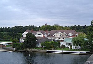
Leander Club
British rowing club
Distance: Approx. 859 meters
Latitude and longitude: 51.53805556,-0.89916667
Leander Club, founded in 1818, is one of the oldest rowing clubs in the world, and the oldest non-academic club. It is based in Remenham in Berkshire, England and adjoins Henley-on-Thames. Only three other surviving clubs were founded prior to Leander: Brasenose College Boat Club and Jesus College Boat Club (the two competing in a Head race in 1815) and Westminster School Boat Club, founded in 1813.

Marsh Lock
Lock and weir on the River Thames in Berkshire, England
Distance: Approx. 774 meters
Latitude and longitude: 51.52803,-0.8871
Marsh Lock is a lock and weir situated on the River Thames in England, about 1 mile upstream of Henley Bridge in Henley-on-Thames, Oxfordshire. The lock is close to the Berkshire bank, but accessed from the Oxfordshire side via two long walkways, the downstream one being near Mill Meadows. The first pound lock was built by the Thames Navigation Commission in 1773.

River and Rowing Museum
Local museum in Henley-on-Thames, England
Distance: Approx. 226 meters
Latitude and longitude: 51.5322,-0.8961
The River & Rowing Museum in Henley-on-Thames, Oxfordshire, England, is located on a site at Mill Meadows by the River Thames. It has three main themes represented by major permanent galleries, the non-tidal River Thames, the international sport of rowing and the local town of Henley-on-Thames.

Mill Meadows, Henley-on-Thames
Distance: Approx. 275 meters
Latitude and longitude: 51.53169,-0.89422
Mill Meadows is part of the flood plain of the River Thames at Henley-on-Thames, Oxfordshire, England. It is an area of natural beauty close to the town centre of Henley. Marsh Lock (which is adjacent to the site of the mill that the meadows are named after.
The Henley College (Henley-on-Thames)
Further education/sixth form college in Henley-on-Thames, Oxon, England
Distance: Approx. 953 meters
Latitude and longitude: 51.536,-0.908
The Henley College is a sixth form college in Henley-on-Thames, Oxfordshire, England. It was founded as a tertiary college in 1987 and changed its status to a sixth form college in 2010.

Henley Bridge
Bridge in Henley-on-Thames
Distance: Approx. 812 meters
Latitude and longitude: 51.5375,-0.90027778
Henley Bridge is a road bridge built in 1786 at Henley-on-Thames over the River Thames, between Oxfordshire and Berkshire. The bridge has five elliptical stone arches, and links Hart Street in Henley with White Hill (designated the A4130) leading up a steep hill to Remenham Hill. It crosses the Thames on the reach between Hambleden Lock and Marsh Lock, carrying the Thames Path across the river.
Henley Town F.C.
Association football club in England
Distance: Approx. 414 meters
Latitude and longitude: 51.52910278,-0.89199722
Henley Town Football Club is a football club based in Henley-on-Thames in Oxfordshire, England. They are currently members of the Thames Valley Premier League Premier Division and play at the Triangle Mill.

Henley-on-Thames railway station
Railway station in Oxfordshire, England
Distance: Approx. 434 meters
Latitude and longitude: 51.534,-0.9
Henley-on-Thames is a terminal railway station in the town of Henley-on-Thames in Oxfordshire, England. The station is on the Henley Branch Line that links the towns of Henley and Twyford. It is 4 miles 47 chains (7.4 km) down the line from Twyford and 35 miles 48 chains (57.3 km) from London Paddington.

Harpsden
Village in Oxfordshire, England
Distance: Approx. 775 meters
Latitude and longitude: 51.524,-0.902
Harpsden is a rural and semi-rural village and civil parish immediately south of Henley-on-Thames in South Oxfordshire, Oxfordshire, England. Its scattered centre is set 0.5 miles (0.80 km) from the east border which is the River Thames, marking a short boundary with Berkshire. The parish extends 5 miles (8.0 km) inland and borders Rotherfield Peppard to the west, that is, next to its main sections of woodland in the southern extreme of the Chiltern Hills including an SSSI area of ancient woodland.

Rod Eyot
Distance: Approx. 379 meters
Latitude and longitude: 51.5325,-0.8933
Rod Eyot or Rod Ait is an island in the River Thames in England near Henley-on-Thames on the reach above Hambledon Lock. It is close to Mill Meadows and the River and Rowing Museum.

Henley Rowing Club
British rowing club
Distance: Approx. 466 meters
Latitude and longitude: 51.533868,-0.89382
Henley Rowing Club is a rowing club on the River Thames based on Wargrave Road, Henley-on-Thames, Oxfordshire.
Weather in this IP's area
mist
11 Celsius
11 Celsius
10 Celsius
12 Celsius
1016 hPa
97 %
1016 hPa
1011 hPa
2400 meters
3.09 m/s
200 degree
100 %
07:33:03
18:03:58