193.228.209.20 - IP Lookup: Free IP Address Lookup, Postal Code Lookup, IP Location Lookup, IP ASN, Public IP
Country:
Region:
City:
Location:
Time Zone:
Postal Code:
ISP:
ASN:
language:
User-Agent:
Proxy IP:
Blacklist:
IP information under different IP Channel
ip-api
Country
Region
City
ASN
Time Zone
ISP
Blacklist
Proxy
Latitude
Longitude
Postal
Route
db-ip
Country
Region
City
ASN
Time Zone
ISP
Blacklist
Proxy
Latitude
Longitude
Postal
Route
IPinfo
Country
Region
City
ASN
Time Zone
ISP
Blacklist
Proxy
Latitude
Longitude
Postal
Route
IP2Location
193.228.209.20Country
Region
salzburg
City
kaprun
Time Zone
Europe/Vienna
ISP
Language
User-Agent
Latitude
Longitude
Postal
ipdata
Country
Region
City
ASN
Time Zone
ISP
Blacklist
Proxy
Latitude
Longitude
Postal
Route
Popular places and events near this IP address

Kaprun disaster
2000 funicular train fire in Austria
Distance: Approx. 5985 meters
Latitude and longitude: 47.22562778,12.72074167
On 11 November 2000, a fire in the tunnel of Gletscherbahn Kaprun 2 funicular in Kaprun, Austria, killed 155 people. The cause was traced to a faulty fan heater. Most of the victims were skiers on their way to the Kitzsteinhorn glacier.

Kaprun
Municipality in Salzburg, Austria
Distance: Approx. 29 meters
Latitude and longitude: 47.2725,12.75944444
Kaprun (German pronunciation: [kaˈpruːn]) is a municipality in the Zell am See District in the province of Salzburg in Austria. Together with the neighboring city of Zell am See the town presents itself as the tourist destination and skiing area "Zell am See-Kaprun". Kaprun distinguishes itself from its larger neighbor at the lake, by offering all year access to the Kitzsteinhorn with its Top of Salzburg viewing platform at 3029 metres (9938') altitude and its glacier ski area that is open October through May.

Zell am See
Municipality in Salzburg, Austria
Distance: Approx. 5787 meters
Latitude and longitude: 47.31666667,12.8
Zell am See is the administrative capital of the Zell am See District in the Austrian state of Salzburg. Located in the Kitzbühel Alps, the town is an important tourist destination due to its ski resorts and shoreline on Lake Zell. While Zell am See has been a favored winter and summer resort for the European aristocracy since the 19th century, it is known as a hub of the international jet set today.
Lake Zell
Lake in Salzburg, Austria
Distance: Approx. 5787 meters
Latitude and longitude: 47.31666667,12.8
Lake Zell (German: Zeller See; Italian: Lago di Zell) is a small freshwater lake in the Austrian Alps. It takes its name from the city of Zell am See, which is located on a small delta protruding into the lake. The lake is 4 kilometres (2.5 mi) long and 1.5 kilometres (0.93 mi) across at its widest.

Bruck an der Großglocknerstraße
Municipality in Salzburg, Austria
Distance: Approx. 5072 meters
Latitude and longitude: 47.28333333,12.825
Bruck an der Großglocknerstraße (Southern Bavarian: Bruck a da Glocknerstrouss) is a municipality in Zell am See District, in the state of Salzburg in Austria.
Piesendorf
Municipality in Salzburg, Austria
Distance: Approx. 3320 meters
Latitude and longitude: 47.26666667,12.71666667
Piesendorf is a municipality in the district of Zell am See (Pinzgau region), in the state of Salzburg in Austria. It lies in the Kitzbühel Alps between Kitzbühel and Zell am See. Due to its location between the ski resorts of Zell am See, Kitzbühel and the Hohe Tauern National Park with Austria's highest mountains, it has become centered on tourism.

Zell am See-Süd
Neighborhood of Zell am See in Austria
Distance: Approx. 4262 meters
Latitude and longitude: 47.30333333,12.79305556
The city district Zell am See-Süd (South Zell am See), official Schüttdorf, is the most populous part, with approximately 5,400 inhabitants, of the district capital Zell am See.

Zell am See Airport
Airport in Austria
Distance: Approx. 3116 meters
Latitude and longitude: 47.29141667,12.79008333
Zell am See Airport (German: Flugplatz Zell am See, ICAO: LOWZ) is a public use airport located 4 kilometres (2 mi) south of Zell am See, Salzburg, Austria. The airport is usable for airplanes up to 5.7 tonnes.
Pinzgau Hut
Building in Salzburg, Austria
Distance: Approx. 6401 meters
Latitude and longitude: 47.322847,12.7191
The Pinzgau Hut or Pinzgauer Hut (German: Pinzgauer Hütte) is a mountain hut at 1,700 m (5,577 ft) above sea level in the Kitzbühel Alps in Salzburg, Austria.
Schmitten Tunnel
Road tunnel in Austria
Distance: Approx. 5010 meters
Latitude and longitude: 47.31166667,12.79222222
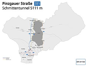
The Schmitten Tunnel (German: Schmittentunnel) is the bypass tunnel for the town of Zell am See in Austria and a road tunnel on the Pinzgau Road (Pinzgauer Straße, B 311) in the Austrian state of Salzburg. The Schmitten Tunnel has a length of 5,111 metres and acts as a relief road for the through road in Zell am See, that is normally very busy. The tunnel stretches from the suburb of Zell am See-Süd to the northern end of the town of Zell am See.
Fuscher Ache
River in Salzburg, Austria
Distance: Approx. 5913 meters
Latitude and longitude: 47.2849,12.8359
The Fuscher Ache is a river of Salzburg, Austria, a right tributary of the River Salzach. The Fuscher Ache rises as the confluence of the Kaefertalbach und the Traunerbach near the Fuscher Törl at a height of about 2,500 m (AA) in the Lower Pinzgau. It flows from south to north through the valley of the same name, passing the small village of Fusch an der Großglocknerstraße.

2007 Zell am See mid-air collision
Aviation accident
Distance: Approx. 3583 meters
Latitude and longitude: 47.30361111,12.77138889
The 2007 Zell am See mid-air collision was an aviation accident that occurred on 5 March 2007, at 10:53 a.m. CET (09:53 UTC), in which eight people died when an Aérospatiale SA 332 Super Puma helicopter, operated by Helog, collided with a private Diamond DV20 Katana light aircraft near Zell am See, Austria. At the time of the accident, both aircraft were operating under visual flight rules.
Weather in this IP's area
overcast clouds
1 Celsius
-2 Celsius
-0 Celsius
1 Celsius
1021 hPa
71 %
1021 hPa
840 hPa
10000 meters
2.72 m/s
1.72 m/s
194 degree
100 %


