Country:
Region:
City:
Latitude and Longitude:
Time Zone:
Postal Code:
IP information under different IP Channel
ip-api
Country
Region
City
ASN
Time Zone
ISP
Blacklist
Proxy
Latitude
Longitude
Postal
Route
Luminati
Country
ASN
Time Zone
Europe/Budapest
ISP
Invitech ICT Services Kft.
Latitude
Longitude
Postal
IPinfo
Country
Region
City
ASN
Time Zone
ISP
Blacklist
Proxy
Latitude
Longitude
Postal
Route
db-ip
Country
Region
City
ASN
Time Zone
ISP
Blacklist
Proxy
Latitude
Longitude
Postal
Route
ipdata
Country
Region
City
ASN
Time Zone
ISP
Blacklist
Proxy
Latitude
Longitude
Postal
Route
Popular places and events near this IP address

Konkoly Observatory
Observatory
Distance: Approx. 5992 meters
Latitude and longitude: 47.4997,18.96389
Konkoly Observatory (Hungarian: HUN-REN Csillagászati és Földtudományi Kutatóközpont Konkoly Thege Miklós Csillagászati Intézet; obs. code: 053) is an astronomical observatory located in Budapest, Hungary is part of the Research Centre for Astronomy and Earth Sciences (Hungarian: Csillagászati és Földtudományi Kutatóközpont) and belongs to the HUN-REN Magyar Kutatási Hálózat. Konkoly Observatory was founded in 1871 by Hungarian astronomer Miklós Konkoly-Thege (1842–1916) as a private observatory, and was donated to the state in 1899. Konkoly Observatory, officially known as HUN-REN CSFK Konkoly Thege Miklós Csillagászati Intézet in Hungarian, is the largest astronomical research institute in Hungary, and hosts the largest telescopes in the country.

Budakeszi
Town in Pest, Hungary
Distance: Approx. 5105 meters
Latitude and longitude: 47.51227,18.92806
Budakeszi (German: Wudigess or Wudigeß) is a town in Pest County, in the Budapest metropolitan area, Hungary. It is located beyond the János Hill at the western city limits of Budapest, about 12 km (7 mi) west of the Zero Kilometre Stone in the city centre. A popular recreational area, the landscape is characterized by forests, predominantly oaks, by vineyards and by orchards.

Budaörs
Town in Pest, Hungary
Distance: Approx. 4859 meters
Latitude and longitude: 47.46072,18.95798
Budaörs (Hungarian: [ˈbudɒørʃ]; German: Wudersch; Croatian: Jerša, Erša or Vundeš; Latin: Vicus Teuto) is a town in Pest County, Budapest metropolitan area, Hungary.

Törökbálint
Place in Pest, Hungary
Distance: Approx. 4127 meters
Latitude and longitude: 47.43666667,18.91222222
Törökbálint [ˈtørøɡbaːlint] is a town in Pest county, Hungary. Törökbálint received town status on 1 July 2007. The city also has a German name, Großturwall, which originates from the times of the Swabian immigration after the Ottoman times of Hungary.

Biatorbágy
Town in Pest, Hungary
Distance: Approx. 5298 meters
Latitude and longitude: 47.47119,18.8252
Biatorbágy (German: Wiehall-Kleinturwall) is a town in Pest County, Budapest metropolitan area, Hungary. It has a population of 13,889 (2019). It was created in 1966 by the merger of Bia (German: Wiehall) and Torbágy (German: Kleinturwall).
Normafa
Distance: Approx. 6322 meters
Latitude and longitude: 47.50277222,18.96623333
Normafa is a popular tourist sight in the Buda Hills. It is mainly known for its panoramic scenery and fresh air. It is located in Svábhegy, a part of the 12th district of Budapest.

Páty
Place in Central Hungary, Hungary
Distance: Approx. 6831 meters
Latitude and longitude: 47.51666667,18.83333333
Páty is a village in Pest county, Budapest metropolitan area, Hungary. It has a population of 7,476 (2018). The neighbouring villages are: Zsámbék, Tök, Budajenő, Telki, Nagykovácsi, Budakeszi, Biatorbágy and Herceghalom.

Elizabeth Lookout
Monument in
Distance: Approx. 7023 meters
Latitude and longitude: 47.51819722,18.95918333
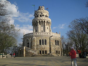
The Elizabeth Lookout (Hungarian: Erzsébet-kilátó) is a historic lookout tower on János Hill (Hungarian: János-hegy) above Budapest. Built in 1911, the tower was named after Empress Elisabeth, wife of Emperor Franz Joseph I. Frigyes Schulek was the architect. The tower is near Budapest's District XII, and may be reached from the Széll Kálmán tér of Budapest.

Music FM (Hungary)
Former radio station in Budapest
Distance: Approx. 6677 meters
Latitude and longitude: 47.4918571,18.97934867
Music FM was a Hungarian commercial radio station, airing at 89.5 FM in Budapest. Its first broadcast was on 7 March 2012. Music FM had a Top 50 popularity chart.

Budakeszi District
Districts of Hungary in Pest
Distance: Approx. 5383 meters
Latitude and longitude: 47.4667,18.9667
Budakeszi (Hungarian: Budakeszi járás) is a district in western part of Pest County. Budakeszi is also the name of the town where the district seat is found. The district is located in the Central Hungary Statistical Region.

Rádió Rock 95.8
Radio station
Distance: Approx. 6677 meters
Latitude and longitude: 47.4918571,18.97934867
Rádió Rock 95.8 was a Hungarian rock music radio station. It was the only radio station in Hungary which broadcast rock music exclusively.

Budaörs Airport
Airport in Hungary
Distance: Approx. 6814 meters
Latitude and longitude: 47.45083333,18.98055556
Budaörs Airport (Hungarian: Budaörsi Repülőtér), (ICAO: LHBS) is an airport located in the 11th district of Budapest, Hungary and was named after the neighboring town Budaörs. Now serving general aviation, it was once Hungary's only international airport.
Weather in this IP's area
few clouds
-0 Celsius
-2 Celsius
-0 Celsius
-0 Celsius
1013 hPa
67 %
1013 hPa
990 hPa
10000 meters
1.71 m/s
2.33 m/s
242 degree
14 %
06:52:34
16:06:35