193.226.210.70 - IP Lookup: Free IP Address Lookup, Postal Code Lookup, IP Location Lookup, IP ASN, Public IP
Country:
 Hungary
Region:
City:
Location:
Time Zone:
Postal Code:
ISP:
ASN:
language:
User-Agent:
Proxy IP:
Blacklist:
IP information under different IP Channel
ip-api
Country
Region
City
ASN
Time Zone
ISP
Blacklist
Proxy
Latitude
Longitude
Postal
Route
db-ip
Country
Region
City
ASN
Time Zone
ISP
Blacklist
Proxy
Latitude
Longitude
Postal
Route
IPinfo
Country
Region
City
ASN
Time Zone
ISP
Blacklist
Proxy
Latitude
Longitude
Postal
Route
IP2Location
193.226.210.70Country
huRegion
pest
City
budaors
Time Zone
Europe/Budapest
ISP
Language
User-Agent
Latitude
Longitude
Postal
ipdata
Country
Region
City
ASN
Time Zone
ISP
Blacklist
Proxy
Latitude
Longitude
Postal
Route
Popular places and events near this IP address

Konkoly Observatory
Observatory
Distance: Approx. 4207 meters
Latitude and longitude: 47.4997,18.96389
Konkoly Observatory (Hungarian: HUN-REN Csillagászati és Földtudományi Kutatóközpont Konkoly Thege Miklós Csillagászati Intézet; obs. code: 053) is an astronomical observatory located in Budapest, Hungary is part of the Research Centre for Astronomy and Earth Sciences (Hungarian: Csillagászati és Földtudományi Kutatóközpont) and belongs to the HUN-REN Magyar Kutatási Hálózat. Konkoly Observatory was founded in 1871 by Hungarian astronomer Miklós Konkoly-Thege (1842–1916) as a private observatory, and was donated to the state in 1899. Konkoly Observatory, officially known as HUN-REN CSFK Konkoly Thege Miklós Csillagászati Intézet in Hungarian, is the largest astronomical research institute in Hungary, and hosts the largest telescopes in the country.

Farkasréti Cemetery
Hungarian cemetery in Budapest
Distance: Approx. 4253 meters
Latitude and longitude: 47.48388889,19.00472222
Farkasréti Cemetery or Farkasrét Cemetery (Hungarian: Farkasréti temető, Hungarian pronunciation: [ˈfɒrkɒsreːti ˈtɛmɛtøː]) is one of the most famous cemeteries in Budapest. It opened in 1894 and is noted for its extensive views of the city (several people wanted it more to be a resort area than a cemetery). It comprises tombs of numerous Hungarian notables and it is the most preferred burial place among actors, actresses and other artists (opera singers, musicians, painters, sculptors, architects, writers, poets).
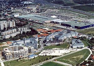
Budaörs
Town in Pest, Hungary
Distance: Approx. 155 meters
Latitude and longitude: 47.46072,18.95798
Budaörs (Hungarian: [ˈbudɒørʃ]; German: Wudersch; Croatian: Jerša, Erša or Vundeš; Latin: Vicus Teuto) is a town in Pest County, Budapest metropolitan area, Hungary.

Törökbálint
Place in Pest, Hungary
Distance: Approx. 4477 meters
Latitude and longitude: 47.43666667,18.91222222
Törökbálint [ˈtørøɡbaːlint] is a town in Pest county, Hungary. Törökbálint received town status on 1 July 2007. The city also has a German name, Großturwall, which originates from the times of the Swabian immigration after the Ottoman times of Hungary.

Normafa
Distance: Approx. 4567 meters
Latitude and longitude: 47.50277222,18.96623333
Normafa is a popular tourist sight in the Buda Hills. It is mainly known for its panoramic scenery and fresh air. It is located in Svábhegy, a part of the 12th district of Budapest.

Kelenföld railway station
Railway station in Budapest, Hungary
Distance: Approx. 4672 meters
Latitude and longitude: 47.46444444,19.02027778
Kelenföld railway station (Hungarian: Kelenföldi vasútállomás or incorrectly Kelenföldi pályaudvar, and until 2007 officially Budapest-Kelenföld) is among Budapest's four busiest railway stations (the others are Keleti pu, Déli pu and Nyugati pu). Opened in 1861, it is situated south-west of the city centre, in Újbuda or District XI in the suburb Kelenföld. Today, Kelenföld is an extremely busy station, with almost all passenger and freight services operated by Hungarian Railways towards Transdanubia passing through.

Gazdagrét
Neighborhood in Buda, Hungary
Distance: Approx. 3146 meters
Latitude and longitude: 47.47083333,18.99805556
Gazdagrét is a neighbourhood of Budapest, the capital of Hungary. It is located in the western part of the 11th district. It is a residential area consisting of prefabricated buildings (see panelház) with a population of 11,929 (2001 census).

Kelenföld vasútállomás metro station
Budapest metro station
Distance: Approx. 4546 meters
Latitude and longitude: 47.46444444,19.01861111
Kelenföld vasútállomás (Kelenföld railway station) is the western terminus of Line 4 of the Budapest Metro. The station was opened on 28 March 2014 as part of the inaugural section of the line, from Keleti pályaudvar to Kelenföld vasútállomás. The station, located under Kelenföld railway station and across some of the busiest railroad tracks in Budapest, can be reached through an underpass.

Music FM (Hungary)
Former radio station in Budapest
Distance: Approx. 3672 meters
Latitude and longitude: 47.4918571,18.97934867
Music FM was a Hungarian commercial radio station, airing at 89.5 FM in Budapest. Its first broadcast was on 7 March 2012. Music FM had a Top 50 popularity chart.

Budakeszi District
Districts of Hungary in Pest
Distance: Approx. 814 meters
Latitude and longitude: 47.4667,18.9667
Budakeszi (Hungarian: Budakeszi járás) is a district in western part of Pest County. Budakeszi is also the name of the town where the district seat is found. The district is located in the Central Hungary Statistical Region.

Rádió Rock 95.8
Radio station
Distance: Approx. 3672 meters
Latitude and longitude: 47.4918571,18.97934867
Rádió Rock 95.8 was a Hungarian rock music radio station. It was the only radio station in Hungary which broadcast rock music exclusively.

Budaörs Airport
Airport in Hungary
Distance: Approx. 2093 meters
Latitude and longitude: 47.45083333,18.98055556
Budaörs Airport (Hungarian: Budaörsi Repülőtér), (ICAO: LHBS) is an airport located in the 11th district of Budapest, Hungary and was named after the neighboring town Budaörs. Now serving general aviation, it was once Hungary's only international airport.
Weather in this IP's area
overcast clouds
4 Celsius
2 Celsius
3 Celsius
4 Celsius
1035 hPa
69 %
1035 hPa
1013 hPa
10000 meters
1.79 m/s
3.58 m/s
131 degree
100 %