193.226.109.178 - IP Lookup: Free IP Address Lookup, Postal Code Lookup, IP Location Lookup, IP ASN, Public IP
Country:
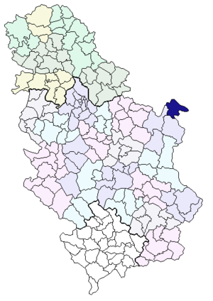
 Romania
Region:
City:
Location:
Time Zone:
Postal Code:
ISP:
ASN:
language:
User-Agent:
Proxy IP:
Blacklist:
IP information under different IP Channel
ip-api
Country
Region
City
ASN
Time Zone
ISP
Blacklist
Proxy
Latitude
Longitude
Postal
Route
db-ip
Country
Region
City
ASN
Time Zone
ISP
Blacklist
Proxy
Latitude
Longitude
Postal
Route
IPinfo
Country
Region
City
ASN
Time Zone
ISP
Blacklist
Proxy
Latitude
Longitude
Postal
Route
IP2Location
193.226.109.178Country
roRegion
mehedinti
City
vrancea
Time Zone
Europe/Bucharest
ISP
Language
User-Agent
Latitude
Longitude
Postal
ipdata
Country
Region
City
ASN
Time Zone
ISP
Blacklist
Proxy
Latitude
Longitude
Postal
Route
Popular places and events near this IP address
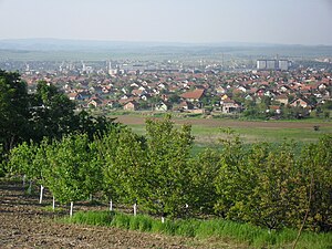
Kladovo
Town and municipality in Southern and Eastern Serbia, Serbia
Distance: Approx. 6917 meters
Latitude and longitude: 44.60666667,22.61305556
Kladovo (Serbian Cyrillic: Кладово, pronounced [klâdɔʋɔ]; Romanian: Cladova or Claudia) is a town and municipality located in the Bor District of eastern Serbia. It is situated on the right bank of the Danube river.
Vajuga
Village in Serbia
Distance: Approx. 2837 meters
Latitude and longitude: 44.5544,22.6328
Vajuga (Serbian Cyrillic: Вајуга) is a village in Serbia in the municipality of Kladovo, in the district of Bor. In 2002, it had 563 inhabitants, of which the majority were Serbs. A necropolis with burials, ceramics and metal items dating to 8th century BC was unearthed at the Vajuga locality.

Korbovo
Village in Bor District, Serbia
Distance: Approx. 8962 meters
Latitude and longitude: 44.52333333,22.70805556
Korbovo is a village in the municipality of Kladovo, Serbia. According to the 2002 census, the village has a population of 1067 people. Korbovo can be reached from Kladovo or from Rtkovo.

Kostol
Village in Bor District, Serbia
Distance: Approx. 7679 meters
Latitude and longitude: 44.60583333,22.64583333
Kostol is a village in the municipality of Kladovo, Serbia. According to the 2002 census, the village has a population of 200 people.

Ljubičevac (Kladovo)
Village in Bor District, Serbia
Distance: Approx. 7752 meters
Latitude and longitude: 44.49111111,22.53805556
Ljubičevac is a village in the municipality of Kladovo, Serbia. According to the 2002 census, the village has a population of 458 people.
Mala Vrbica (Kladovo)
Village in Bor District, Serbia
Distance: Approx. 9260 meters
Latitude and longitude: 44.59944444,22.68805556
Mala Vrbica is a village in the municipality of Kladovo, Serbia. According to the 2002 census, the village has a population of 783 people.
Milutinovac
Village in Bor District, Serbia
Distance: Approx. 2086 meters
Latitude and longitude: 44.55055556,22.57416667
Milutinovac is a village in the municipality of Kladovo, Serbia. According to the 2002 census, the village has a population of 186 people.
Podvrška
Village in Bor District, Serbia
Distance: Approx. 8948 meters
Latitude and longitude: 44.58333333,22.5
Podvrška is a village in the municipality of Kladovo, Serbia. According to the 2002 census, the village has a population of 1143 people.
Rečica (Kladovo)
Village in Bor District, Serbia
Distance: Approx. 5224 meters
Latitude and longitude: 44.56472222,22.53944444
Rečica is a village in the municipality of Kladovo, Serbia. According to the 2002 census, the village has a population of 45 people.
Velesnica
Village in Kladovo/Bor District, Serbia
Distance: Approx. 4904 meters
Latitude and longitude: 44.51805556,22.55083333
Velesnica is a village in the municipality of Kladovo, Serbia. According to the 2002 census, the village has a population of 265 people.
Velika Kamenica
Village in Bor District, Serbia
Distance: Approx. 7999 meters
Latitude and longitude: 44.53333333,22.5
Velika Kamenica is a village in the municipality of Kladovo, Serbia. According to the 2002 census, the village has a population of 757 people.

Fetislam
Distance: Approx. 7823 meters
Latitude and longitude: 44.61555556,22.60194444
Fetislam is a fortification situated a few kilometers upstream from the town of Kladovo, on the right bank of the Danube in Serbia.
Weather in this IP's area
clear sky
-2 Celsius
-2 Celsius
-2 Celsius
-2 Celsius
1034 hPa
52 %
1034 hPa
1017 hPa
10000 meters
1.24 m/s
1.29 m/s
51 degree