Country:
 Italy
ItalyRegion:
City:
Latitude and Longitude:
Time Zone:
Postal Code:
IP information under different IP Channel
ip-api
Country
Region
City
ASN
Time Zone
ISP
Blacklist
Proxy
Latitude
Longitude
Postal
Route
IPinfo
Country
Region
City
ASN
Time Zone
ISP
Blacklist
Proxy
Latitude
Longitude
Postal
Route
MaxMind
Country
Region
City
ASN
Time Zone
ISP
Blacklist
Proxy
Latitude
Longitude
Postal
Route
Luminati
Country
ITASN
Time Zone
Europe/Rome
ISP
TIM
Latitude
Longitude
Postal
db-ip
Country
Region
City
ASN
Time Zone
ISP
Blacklist
Proxy
Latitude
Longitude
Postal
Route
ipdata
Country
Region
City
ASN
Time Zone
ISP
Blacklist
Proxy
Latitude
Longitude
Postal
Route
Popular places and events near this IP address

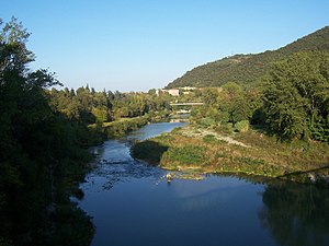
Casalecchio di Reno
Comune in Emilia-Romagna, Italy
Distance: Approx. 1340 meters
Latitude and longitude: 44.48333333,11.28333333
Casalecchio di Reno (Bolognese: Caṡalàcc') is a town and comune in the Metropolitan City of Bologna, Emilia-Romagna, northern Italy.
Battle of Casalecchio
1402 battle in Italy
Distance: Approx. 1337 meters
Latitude and longitude: 44.4833,11.2833
The Battle of Casalecchio took place on 26 June 1402 near the town of Casalecchio di Reno, near Bologna, in northern Italy. A Bolognese army under Giovanni Bentivoglio opposed Gian Galeazzo Visconti, Duke of Milan. The city of Bologna was aided by the Republic of Florence that supplied 5,000 cavalry (Rose Brigade) commanded by Bernardo della Serra.
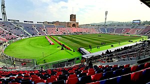
Stadio Renato Dall'Ara
Football stadium
Distance: Approx. 3649 meters
Latitude and longitude: 44.49222222,11.30972222
Stadio Renato Dall'Ara is a multi-purpose stadium in Bologna, Italy. It is currently used mostly for football matches and the home of Bologna FC. The stadium was designed by Giulio Ulisse Arata and inaugurated in 1927 as Stadio Littoriale. It was one of the first stadiums to incorporate the stands into the architecture, an innovation which later became the model for stadiums around the world.

Unipol Arena
Indoor sporting arena in the Province of Bologna, Italy
Distance: Approx. 1657 meters
Latitude and longitude: 44.48583611,11.24812778
Unipol Arena (previously known as Futurshow Station, PalaMalaguti and originally Palasport Casalecchio) is an indoor sporting arena located in Casalecchio di Reno, Province of Bologna, Italy. The seating capacity of the arena for basketball games is 11,000 people, and the seating capacity for concerts is 20,000 people. It was opened in December 1993.

CINECA
Italian non-profit consortium
Distance: Approx. 944 meters
Latitude and longitude: 44.48638889,11.25972222
Cineca is a non-profit consortium, made up of 69 Italian universities, 27 national public research centres, the Italian Ministry of Universities and Research (MUR) and the Italian Ministry of Education (MI), and was established in 1969 in Casalecchio di Reno, Bologna. It is the most powerful supercomputing centre for scientific research in Italy, as stated in the TOP500 list of the most powerful supercomputers in the world: Marconi100, is ranked at the 18th position of the list as of November 2021, with about 30 P/FLOPS. The consortium's institutional mission is to support the Italian scientific community through supercomputing and scientific visualisation tools. Since the end of the 1980s, Cineca has broadened the scope of its mission by embracing other IT sectors, developing management and administrative services for universities and designing ICT systems for the exchange of information between the MIUR and the Italian national academic system.

Madonna di San Luca, Bologna
Basilica church in Bologna, Italy
Distance: Approx. 2446 meters
Latitude and longitude: 44.48,11.298
The Sanctuary of the Madonna of San Luca is a basilica church in Bologna, northern Italy, sited atop a forested hill, Colle or Monte della Guardia, some 300 metres above the city plain, just south-west of the historical centre of the city. While a road now leads up to the sanctuary, it is also possible to reach it along a 3.8 km monumental roofed arcade (Porticoes of Bologna) consisting of 666 arches, which was built in 1674–1793. It was meant to protect the icon as it was paraded up the hill.

Certosa di Bologna
Distance: Approx. 3830 meters
Latitude and longitude: 44.49638889,11.30944444
The Certosa di Bologna is a former Carthusian monastery (or charterhouse) in Bologna, northern Italy, which was founded in 1334 and suppressed in 1797. In 1801 it became the city's Monumental Cemetery which would be much praised by Byron and others. In 1869 an Etruscan necropolis, which had been in use from the sixth to the third centuries BC, was discovered here.

Arco del Meloncello, Bologna
Distance: Approx. 3663 meters
Latitude and longitude: 44.4901,11.311
The Arco del Meloncello is an 18th-century Rococo structure in Bologna, that forms a pedestrian portico over the road (hence an arch); it is part of the Portico di San Luca, a long arcade that sheltered the walk from the Cathedral of Bologna to the hillside Sanctuary of San Luca, Bologna. It lies beyond the gates of the Porta Saragozza, outside the former city walls of Bologna. The arch solved the problem of a site where two roads intersected at right angles, and allowed the foot traffic of the pilgrims to proceed above the road, Via Saragozza, uninterrupted.
Casteldebole railway station
Railway station in Emilia-Romagna, Italy
Distance: Approx. 2692 meters
Latitude and longitude: 44.5034,11.2746
Casteldebole (Italian: Stazione di Casteldebole) is a railway station serving the suburb of Casteldebole, part of the city of Bologna, in the region of Emilia-Romagna, northern Italy. The station opened in 2002 and is located on the Porrettana railway. The train services are operated by Trenitalia Tper.

1990 Italian Air Force MB-326 crash
Air accident in Italy
Distance: Approx. 158 meters
Latitude and longitude: 44.47944444,11.26527778
On 6 December 1990, an MB-326 military jet of the Italian Air Force crashed into a school building at Casalecchio di Reno, near Bologna, Italy, killing 12 students and injuring 88 other students and staff. The aircraft had been abandoned minutes earlier by its pilot, who ejected following an on-board fire and loss of control. The pilot and two senior air force officers were later put on trial and found guilty of involuntary manslaughter, receiving a sentence of 2+1⁄2 years in prison, but were subsequently acquitted on appeal.
Casalecchio Garibaldi railway station
Railway station in Italy
Distance: Approx. 558 meters
Latitude and longitude: 44.483,11.2726
Casalecchio Garibaldi (Italian: Stazione di Casalecchio Garibaldi) is a railway station serving Casalecchio di Reno, in the region of Emilia-Romagna, northern Italy. The station opened in 2002 and is located on the Porrettana railway. It is also the terminus of the Bologna-Vignola railway.
Casalecchio Palasport railway station
Railway station in Emilia-Romagna, Italy
Distance: Approx. 1578 meters
Latitude and longitude: 44.4846,11.2485
Casalecchio Palasport (Italian: Stazione di Casalecchio Palasport) is a railway station serving Casalecchio di Reno, in the region of Emilia-Romagna, northern Italy. The station is located on the Casalecchio-Vignola railway. The train services are operated by Trenitalia Tper.
Weather in this IP's area
mist
16 Celsius
16 Celsius
15 Celsius
18 Celsius
1016 hPa
94 %
1016 hPa
1007 hPa
2500 meters
4.63 m/s
260 degree
75 %
07:35:16
18:24:05