193.201.65.121 - IP Lookup: Free IP Address Lookup, Postal Code Lookup, IP Location Lookup, IP ASN, Public IP
Country:
Region:
City:
Location:
Time Zone:
Postal Code:
ISP:
ASN:
language:
User-Agent:
Proxy IP:
Blacklist:
IP information under different IP Channel
ip-api
Country
Region
City
ASN
Time Zone
ISP
Blacklist
Proxy
Latitude
Longitude
Postal
Route
db-ip
Country
Region
City
ASN
Time Zone
ISP
Blacklist
Proxy
Latitude
Longitude
Postal
Route
IPinfo
Country
Region
City
ASN
Time Zone
ISP
Blacklist
Proxy
Latitude
Longitude
Postal
Route
IP2Location
193.201.65.121Country
Region
england
City
hirst
Time Zone
Europe/London
ISP
Language
User-Agent
Latitude
Longitude
Postal
ipdata
Country
Region
City
ASN
Time Zone
ISP
Blacklist
Proxy
Latitude
Longitude
Postal
Route
Popular places and events near this IP address

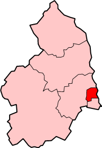
Wansbeck District
Former local government district in England
Distance: Approx. 1547 meters
Latitude and longitude: 55.169,-1.574
Wansbeck was a local government district in south-east Northumberland, England. Its main population centres were Ashington, Bedlington and Newbiggin-by-the-Sea. The area which was bounded by the district is mostly urban, on the North Sea coast north of the Tyneside conurbation.

River Wansbeck
River in Northumberland, England
Distance: Approx. 1415 meters
Latitude and longitude: 55.1619,-1.5294
The River Wansbeck runs through the county of Northumberland, England. It rises above Sweethope Lough on the edge of Fourlaws Forest in the area known locally as The Wanneys (Great Wanney Crag, Little Wanney Crag; thus the "Wanneys Beck"); runs through the town of Ashington before discharging into the North Sea at Sandy Bay near Newbiggin-by-the-Sea. The River flows through the village of Kirkwhelpington, Hartburn, where the tributary Hart Burn joins, the village of Mitford, where the River Font joins, and the town of Morpeth.
Ashington A.F.C.
Association football club in England
Distance: Approx. 2060 meters
Latitude and longitude: 55.1852,-1.5505
Ashington Association Football Club is a football club based in Ashington, Northumberland, England. They are currently members of the Northern Premier League Division One East and play at Woodhorn Lane. Formed in 1883, the club have played in a number of local and regional leagues, including the Northern Alliance, the East Northumberland League, the North Eastern League, the Midland League, Wearside League and the North Regional League.
Bomarsund, Northumberland
Village in Northumberland, England
Distance: Approx. 1902 meters
Latitude and longitude: 55.154,-1.57
Bomarsund is a village in Northumberland, in England. It is situated to the north of Bedlington, and just south of Stakeford. The village grew around a coal pit opened in 1854 and was named after the August 1854 battle – part of the Crimean War – at the fortress of Bomarsund in Sund, Åland, now part of Finland.

Wansbeck General Hospital
Hospital in England
Distance: Approx. 1993 meters
Latitude and longitude: 55.18444444,-1.54583333
Wansbeck General Hospital is a district general hospital based in Ashington, Northumberland, England. It is managed by Northumbria Healthcare NHS Foundation Trust.

Ashington
Town and parish in Northumberland, England
Distance: Approx. 1960 meters
Latitude and longitude: 55.181,-1.568
Ashington is a town and civil parish in Northumberland, England, with a population of 27,864 at the 2011 Census. It was once a centre of the coal mining industry. The town is 15 miles (24 km) north of Newcastle upon Tyne, west of the A189 and bordered to the south by the River Wansbeck.
Northumberland College
College in Northumberland, UK
Distance: Approx. 889 meters
Latitude and longitude: 55.17333333,-1.55777778
Northumberland College is a further education college based in Ashington, Northumberland, England. The present site opened in 1957, and became the County Technical College in 1961, transformed again in 1987, becoming the Northumberland College of Arts and Technology, and finally settled upon its current status in 1995. It has 2 main campuses, one in Ashington in the south east of the County and one in Ponteland at Kirkley Hall.

Ashington railway station
Railway station in Northumberland, England
Distance: Approx. 2245 meters
Latitude and longitude: 55.182,-1.573
Ashington is a railway station on the Northumberland Line, which runs between Newcastle and Ashington. The station serves the town of Ashington in Northumberland, England. It is owned by Network Rail and managed by Northern Trains.
NCEA Duke's Secondary School
Academy in Ashington, Northumberland, England
Distance: Approx. 1024 meters
Latitude and longitude: 55.1758,-1.5477
The NCEA Duke's Secondary School is an 11–19 academy in Ashington, Northumberland, England. It is part of the Northumberland Church of England Trust occupying the Josephine Butler Campus of its predecessor, The Northumberland Church of England Academy, which was an all-through school spread out across six campuses in southeastern Northumberland.
North Seaton railway station
Disused railway station in Ashington, Northumberland
Distance: Approx. 1030 meters
Latitude and longitude: 55.1694,-1.5655
North Seaton railway station served the town of Ashington, Northumberland, England from 1859 to 1964 on the Blyth and Tyne Railway.

Cambois Rowing Club
British rowing club
Distance: Approx. 1241 meters
Latitude and longitude: 55.166774,-1.569524
Cambois Rowing Club is a rowing club on the River Wansbeck, based at Blackclose Bank, Riverside Park, Ashington, Northumberland and is affiliated to British Rowing.

Blyth and Ashington (UK Parliament constituency)
Parliamentary constituency in the United Kingdom, 2024 onwards
Distance: Approx. 2253 meters
Latitude and longitude: 55.15,-1.57
Blyth and Ashington is a constituency represented in the House of Commons of the UK Parliament since 2024 by Ian Lavery of the Labour Party. Created as a result of the 2023 Periodic Review of Westminster constituencies, it was first contested at the 2024 general election and is currently held by Ian Lavery of the Labour Party, who previously held the abolished constituency of Wansbeck from 2010 to 2024.
Weather in this IP's area
few clouds
6 Celsius
3 Celsius
5 Celsius
6 Celsius
975 hPa
75 %
975 hPa
970 hPa
10000 meters
4.12 m/s
200 degree
20 %