Country:
 Great Britain
Region:
City:
Latitude and Longitude:
Time Zone:
Postal Code:
IP information under different IP Channel
ip-api
Country
Region
City
ASN
Time Zone
ISP
Blacklist
Proxy
Latitude
Longitude
Postal
Route
IPinfo
Country
Region
City
ASN
Time Zone
ISP
Blacklist
Proxy
Latitude
Longitude
Postal
Route
MaxMind
Country
Region
City
ASN
Time Zone
ISP
Blacklist
Proxy
Latitude
Longitude
Postal
Route
Luminati
Country
GBASN
Time Zone
Europe/London
ISP
CW Vodafone Group PLC
Latitude
Longitude
Postal
db-ip
Country
Region
City
ASN
Time Zone
ISP
Blacklist
Proxy
Latitude
Longitude
Postal
Route
ipdata
Country
Region
City
ASN
Time Zone
ISP
Blacklist
Proxy
Latitude
Longitude
Postal
Route
Popular places and events near this IP address

Gracechurch Street
Main road in the City of London
Distance: Approx. 97 meters
Latitude and longitude: 51.51194444,-0.08472222
Gracechurch Street is a main road in the City of London, the historic and financial centre of London, England, which is designated the A1213. It is home to a number of shops, restaurants, and offices and has an entrance to Leadenhall Market, a covered market dating from the 14th century.

St Margaret Pattens
Church in London, England
Distance: Approx. 90 meters
Latitude and longitude: 51.51076389,-0.08298333
St Margaret Pattens is a Church of England church in the City of London, located on Eastcheap near the Monument. The dedication is to Saint Margaret of Antioch.

30 Fenchurch Street
Distance: Approx. 84 meters
Latitude and longitude: 51.5112,-0.0824
30 Fenchurch Street is one of the largest office developments in the City of London, the primary financial district of London. Until October 2020, the building was known as Plantation Place, taking its name from a previous Plantation House, once the world's recognised centre of the tea trade. Its anchor tenant is Accenture but it is also the headquarters of a number of other consultancy firms, banks and insurance companies, including Aspen Insurance, IQUW, Sedgwick and QBE Insurance.

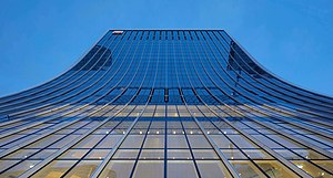
20 Fenchurch Street
Skyscraper in London, England
Distance: Approx. 14 meters
Latitude and longitude: 51.51138889,-0.08361111
20 Fenchurch Street is a commercial skyscraper in London that takes its name from its address on Fenchurch Street, in the historic City of London financial district. It has been nicknamed "The Walkie-Talkie" because of its distinctive shape, said to resemble a walkie-talkie handset. Construction was completed in spring 2014, and the three-floor "sky garden" was opened in January 2015.
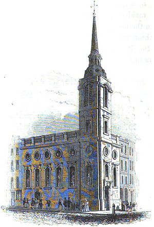
St Benet Gracechurch
Former church in London
Distance: Approx. 105 meters
Latitude and longitude: 51.51166667,-0.085
St Benet Gracechurch (or Grass Church), so called because a haymarket existed nearby (Cobb), was a parish church in the City of London. First recorded in the 11th century, it was destroyed in the Great Fire of London of 1666 and rebuilt by the office of Sir Christopher Wren. The church was demolished in 1868.

Lime Street, London
Distance: Approx. 45 meters
Latitude and longitude: 51.511834,-0.083876
Lime Street is a minor road in the City of London between Fenchurch Street to the south and Leadenhall Street to the north. Its name comes from the lime burners who once sold lime from there for use in construction. It is perhaps best known as the current home of the world's largest insurance market, Lloyd's of London, since its newest building was opened on the street in 1986.
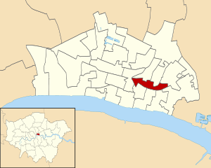
Langbourn
Ward of the City of London
Distance: Approx. 117 meters
Latitude and longitude: 51.512,-0.085
Langbourn is one of the 25 ancient wards of the City of London. It reputedly is named after a buried stream in the vicinity. It is a small ward; a long thin area, running in a west–east direction.

St Dionis Backchurch
Former church-site in London
Distance: Approx. 56 meters
Latitude and longitude: 51.51194444,-0.08388889
St Dionis Backchurch was a parish church in the Langbourn ward of the City of London. Of medieval origin, it was rebuilt after the Great Fire of London to the designs of Christopher Wren and demolished in 1878.

Bridge (City of London ward)
Ward of the City of London
Distance: Approx. 117 meters
Latitude and longitude: 51.511,-0.085
Bridge and Bridge Without is a small ward in the City of London and is named from its closeness to London Bridge. Since boundary changes in 2003, Bridge is bounded by the River Thames to the south, Swan Lane and Gracechurch Street to the west, Fenchurch Street to the north, and Rood Lane and Lovat Lane to the east. The ward includes Fishmongers' Hall, St.

Philpot Lane
Street in the City of London, England
Distance: Approx. 58 meters
Latitude and longitude: 51.51110278,-0.08406111
Philpot Lane is a short street in London, United Kingdom, running from Eastcheap in the south to Fenchurch Street in the north. It is named after Sir John Philpot, Lord Mayor of London from 1378 to 1379. It is the site of London's smallest public statue, The Two Mice Eating Cheese, on a building near the junction with Eastcheap.

The Ship Tavern, Lime Street
Pub in Lime Street, City of London
Distance: Approx. 57 meters
Latitude and longitude: 51.512016,-0.0834785
The Ship is a pub at 27 Lime Street, London EC3. It is a Grade II listed building, built in the mid-19th century.
Kleinwort Hambros
Bank
Distance: Approx. 17 meters
Latitude and longitude: 51.51138889,-0.08333333
SG Kleinwort Hambros is a private bank owned by Société Générale that offers financial services from offices throughout the United Kingdom, Channel Islands and Gibraltar.
Weather in this IP's area
scattered clouds
14 Celsius
14 Celsius
13 Celsius
15 Celsius
1004 hPa
92 %
1004 hPa
1000 hPa
10000 meters
3.09 m/s
110 degree
40 %
06:24:43
19:31:29