Country:
Region:
City:
Latitude and Longitude:
Time Zone:
Postal Code:
IP information under different IP Channel
ip-api
Country
Region
City
ASN
Time Zone
ISP
Blacklist
Proxy
Latitude
Longitude
Postal
Route
Luminati
Country
ASN
Time Zone
Europe/Budapest
ISP
Invitech ICT Services Kft.
Latitude
Longitude
Postal
IPinfo
Country
Region
City
ASN
Time Zone
ISP
Blacklist
Proxy
Latitude
Longitude
Postal
Route
db-ip
Country
Region
City
ASN
Time Zone
ISP
Blacklist
Proxy
Latitude
Longitude
Postal
Route
ipdata
Country
Region
City
ASN
Time Zone
ISP
Blacklist
Proxy
Latitude
Longitude
Postal
Route
Popular places and events near this IP address

Buda
Ancient capital of the Kingdom of Hungary
Distance: Approx. 648 meters
Latitude and longitude: 47.46666667,19.05
Buda (Hungarian pronunciation: [ˈbudɒ], German: Ofen) is the part of Budapest, the capital city of Hungary, that lies on the western bank of the Danube. Historically, “Buda” referred only to the royal walled city on Castle Hill (Hungarian: Várhegy), which was constructed by Béla IV between 1247 and 1249 and subsequently served as the capital of the Kingdom of Hungary from 1361 to 1873. In 1873, Buda was administratively unified with Pest and Óbuda to form modern Budapest.

Lands of the Crown of Saint Stephen
Official name for the Hungarian territories of Austria-Hungary
Distance: Approx. 648 meters
Latitude and longitude: 47.46666667,19.05
The Lands of the Crown of Saint Stephen (Hungarian: a Szent Korona Országai), informally Transleithania (meaning the lands or region "beyond" the Leitha River), were the Hungarian territories of Austria-Hungary, throughout the latter's entire existence (30 March 1867 – 16 November 1918), and which disintegrated following its dissolution. The name referenced the historic coronation crown of Hungary, known as the Crown of Saint Stephen of Hungary, which had a symbolic importance to the Kingdom of Hungary. According to the First Article of the Croatian–Hungarian Settlement of 1868, this territory, also called Arch-Kingdom of Hungary (Archiregnum Hungaricum, pursuant to Medieval Latin terminology), was officially defined as "a state union of the Kingdom of Hungary and the Triune Kingdom of Croatia, Slavonia and Dalmatia".

Central Hungary
Region in Hungary
Distance: Approx. 917 meters
Latitude and longitude: 47.47194444,19.05027778
Central Hungary (Hungarian: Közép-Magyarország pronounced [ˈkøzeːp ˈmɒɟɒrorsaːɡ]) is one of the eight statistical regions in Hungary (NUTS 1 and NUTS 2). It includes Pest County and since 2018 no longer includes Budapest, the capital of the region.
Kelenföld
Neighborhood in Budapest, Hungary
Distance: Approx. 648 meters
Latitude and longitude: 47.46666667,19.05
Kelenföld (German: Krenfeld) is a neighborhood in Budapest, Hungary. It belongs to Újbuda, and located in the southern part of Buda. The large Kelenföld housing estate was built between 1967 and 1983 from pre-fabricated concrete blocks.

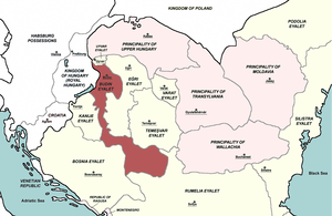
Budin Eyalet
1541–1686 Ottoman province in Hungary and Serbia
Distance: Approx. 648 meters
Latitude and longitude: 47.46666667,19.05
Budin Eyalet (also known as Province of Budin/Buda or Pashalik of Budin/Buda, Ottoman Turkish: ایالت بودین, romanized: Eyālet-i Budin) was an administrative territorial entity of the Ottoman Empire in Central Europe and the Balkans. It was formed on the territories that Ottoman Empire conquered from the medieval Kingdom of Hungary and Serbian Despotate. The capital of the Budin Province was Budin (Hungarian: Buda).

Újbuda
District of Budapest in Central Hungary, Hungary
Distance: Approx. 974 meters
Latitude and longitude: 47.475,19.04
Újbuda (lit. New Buda) is the 11th district of Budapest (Hungarian: Budapest XI. kerület), Hungary. It is the most populous district of Budapest with 137,426 inhabitants (2008).
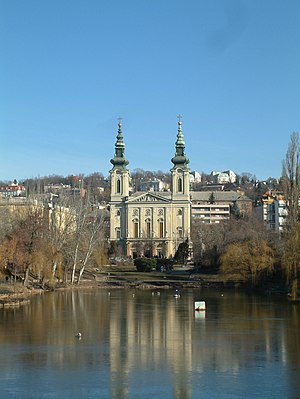
Lake Feneketlen
Pond in Budapest, Hungary
Distance: Approx. 1154 meters
Latitude and longitude: 47.47666667,19.04138889
Lake Feneketlen (Feneketlen-tó, "Bottomless Lake") is a pond in the 11th district of Budapest, Hungary. The lake was formed in 1877, when clay was removed from the site to supply a brick factory that was situated at nearby Kosztolányi Dezső tér. The lake's water quality in the 1980s began to deteriorate, until a water circulation device was built.

Siege of Buda (1684)
Siege in the Great Turkish War
Distance: Approx. 648 meters
Latitude and longitude: 47.4666,19.05
The siege of Buda (14 July – 30 October 1684) was a siege by the Holy Roman Empire of the Ottoman fortress of Buda. After 109 days, the siege was abandoned.

Dennis Gabor University
University in Hungary
Distance: Approx. 346 meters
Latitude and longitude: 47.4652,19.0371
Dennis Gabor University (DGU) (Hungarian: Gábor Dénes Egyetem, GDE) is a private educational institution in Budapest, Hungary. It was established in 1992 as a college, and named after the Hungarian physicist Dennis Gabor (Hungarian: Gábor Dénes). It attained the rank of university in 2023.

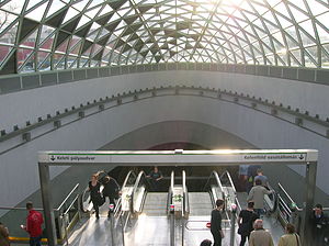
Bikás park metro station
Budapest metro station
Distance: Approx. 644 meters
Latitude and longitude: 47.465,19.03305556
Bikás park is a station on Line 4 of the Budapest Metro. The station is located in the Kelenföld neighborhood in southern Buda. Its name is derived from the park (Bulls Park) in which the station entrance is located.

Újbuda-központ metro station
Budapest metro station
Distance: Approx. 937 meters
Latitude and longitude: 47.47416667,19.04583333
Újbuda-központ (lit. "Újbuda-Centrum") is a station on Line 4 of the Budapest Metro. The station is an important traffic junction.

Lágymányos
Neighborhood in Budapest, Hungary
Distance: Approx. 648 meters
Latitude and longitude: 47.46666667,19.05
Lágymányos is a neighbourhood in the district of Újbuda in Budapest, Hungary. In 2001, Lágymányos had a population of 19,741. The Budapest University of Technology and Economics is located here, as well as some faculties of Eötvös Loránd University.
Weather in this IP's area
fog
1 Celsius
-2 Celsius
0 Celsius
1 Celsius
1013 hPa
98 %
1013 hPa
1001 hPa
400 meters
2.06 m/s
280 degree
100 %
06:51:58
16:06:01

