Country:
 Sweden
Region:
City:
Latitude and Longitude:
Time Zone:
Postal Code:
IP information under different IP Channel
ip-api
Country
Region
City
ASN
Time Zone
ISP
Blacklist
Proxy
Latitude
Longitude
Postal
Route
IPinfo
Country
Region
City
ASN
Time Zone
ISP
Blacklist
Proxy
Latitude
Longitude
Postal
Route
MaxMind
Country
Region
City
ASN
Time Zone
ISP
Blacklist
Proxy
Latitude
Longitude
Postal
Route
Luminati
Country
SERegion
ab
City
stockholm
ASN
Time Zone
Europe/Stockholm
ISP
Obenetwork AB
Latitude
Longitude
Postal
db-ip
Country
Region
City
ASN
Time Zone
ISP
Blacklist
Proxy
Latitude
Longitude
Postal
Route
ipdata
Country
Region
City
ASN
Time Zone
ISP
Blacklist
Proxy
Latitude
Longitude
Postal
Route
Popular places and events near this IP address
Kista
District in Rinkeby-Kista, Stockholm, Sweden
Distance: Approx. 742 meters
Latitude and longitude: 59.40138889,17.94444444
Kista (Swedish pronunciation: [ˈɕǐːsta], meaning "place where livestock is traded", from the Old Swedish word "kvi", meaning livestock, and "sta(d)", meaning place) is a district in the borough of Rinkeby-Kista, Stockholm, Sweden. It has a strategic position located in between Sweden's main airport, the Stockholm-Arlanda International Airport and central Stockholm, and alongside the main national highway E4 economic artery. Kista comprises residential and commercial areas, the latter in the highly technological telecommunications and information technology industry.

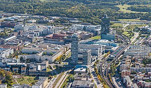
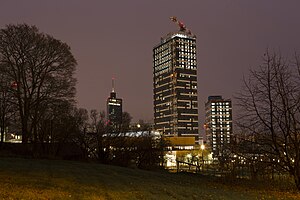
Kista Science Tower
Commercial offices in Stockholm, Sweden
Distance: Approx. 593 meters
Latitude and longitude: 59.402,17.947
Kista Science Tower is a 32-story, 124 m (407 ft) skyscraper in Kista, Stockholm, Sweden. With its roof-top antenna, its height is 156 m (512 ft), making it one of the tallest buildings in the country, just between Turning Torso and Scandic Victoria Tower. The black cube on top of the roof is, contrary to some rumors, not meant to be the start of more floors; it is the top of the elevator shaft and space for the electronics for the antenna.
Kymlinge
Area and a ghost metro station in Stockholm
Distance: Approx. 1432 meters
Latitude and longitude: 59.39444444,17.965
Kymlinge (Swedish pronunciation: [ˈɕʏ̂mlɪŋɛ]) is an area of Sundbyberg Municipality, Stockholm County, Sweden. It is mostly a recreational park, part of which is a nature reserve (Igelbäcken).

Eggeby stone
Distance: Approx. 2029 meters
Latitude and longitude: 59.3975,17.92222222
The Eggeby stone, designated as U 69 under the Rundata catalog, is a Viking Age memorial runestone that is located at Eggeby, which is 2 kilometers northwest of Central Sundbyberg, Sweden, which was in the historic province of Uppland.
Rinkeby-Kista
Borough of Stockholm in Stockholm Municipality, Sweden
Distance: Approx. 790 meters
Latitude and longitude: 59.401,17.944
Rinkeby-Kista is a borough (stadsdelsområde) in Stockholm, Sweden. The borough is located in Västerort.

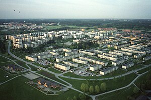
Husby, Stockholm
Urban district in northern Stockholm, Sweden
Distance: Approx. 1575 meters
Latitude and longitude: 59.40944444,17.92694444
Husby is a district (Swedish: stadsdel) in the Järva borough in Stockholm, Sweden. Husby has 11,957 inhabitants as of December 31, 2023.

Husby metro station
Stockholm Metro station
Distance: Approx. 1675 meters
Latitude and longitude: 59.41027778,17.92555556
Husby is a station on the blue line of the Stockholm metro, located in the district of Husby, northern Stockholm. The station was inaugurated on 5 June 1977 as part of the extension from Hallonbergen to Akalla. The distance to Kungsträdgården is 15 km (9.3 mi).
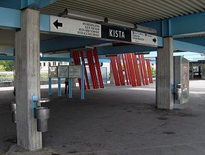
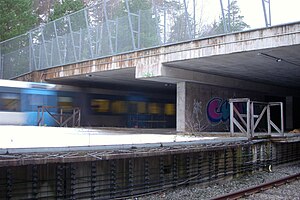
Kista metro station
Stockholm Metro station
Distance: Approx. 766 meters
Latitude and longitude: 59.40277778,17.94194444
Kista metro station is a station on the blue line of the Stockholm metro, located in the district of Kista, northern Stockholm. The distance to Kungsträdgården is 15.9 km (9.9 mi). It was opened on 5 June 1977 as part of the extension from Hallonbergen to Akalla.

Uppland Runic Inscription Fv1953;263
Rundata catalog listing for a Viking Age memorial runestone
Distance: Approx. 1173 meters
Latitude and longitude: 59.4158,17.9615
Uppland Runic Inscription Fv1953;263 or U Fv1953;263 is the Rundata catalog listing for a Viking Age memorial runestone that was discovered at Helenelund, which is in Sollentuna, Stockholm County, Sweden, which was in the historic province of Uppland.

Scandic Victoria Tower
Hotel in Stockholm, Sweden
Distance: Approx. 232 meters
Latitude and longitude: 59.407,17.9575
The Scandic Victoria Tower is a skyscraper hotel in the Kista district of Stockholm, Sweden. It is also known as the Victoria Tower, however the Scandic name is used to distinguish it from the Victoria Tower that forms the southwest end of the Palace of Westminster. The 117 metre hotel is one of the tallest buildings in Stockholm, as well as the tallest hotel in Scandinavia.
Kista Torn
Residential in Stockholm, Sweden
Distance: Approx. 698 meters
Latitude and longitude: 59.4048,17.9418
Kista Torn (in English, Kista Towers) is a pair of 19- and 40-storey apartment buildings, connected at their base. The towers are situated on Borgarfjordsgatan in the Kista district of Stockholm, Sweden. The highest tower ("K1") stands at 117.9 m (387 ft) tall, which made it the tallest residential skyscraper in Stockholm on its completion in 2015.

Kista Galleria
Shopping mall in Stockholm, Sweden
Distance: Approx. 616 meters
Latitude and longitude: 59.40272222,17.94513889
Kista Galleria is a shopping mall located in the Kista Science City in Stockholm, Sweden. It has 185 stores, including a multiplex, bowling alley, karting track and restaurants. Known for its generous opening hours (9 AM to 9 PM), it has been the most visited mall in Stockholm with approximately 18 million customers annually, and the third largest in terms of sales.
Weather in this IP's area
few clouds
11 Celsius
11 Celsius
11 Celsius
12 Celsius
1021 hPa
81 %
1021 hPa
1017 hPa
10000 meters
4.63 m/s
150 degree
20 %
07:38:41
17:26:50