Country:
 Netherlands
Region:
City:
Latitude and Longitude:
Time Zone:
Postal Code:
IP information under different IP Channel
ip-api
Country
Region
City
ASN
Time Zone
ISP
Blacklist
Proxy
Latitude
Longitude
Postal
Route
IPinfo
Country
Region
City
ASN
Time Zone
ISP
Blacklist
Proxy
Latitude
Longitude
Postal
Route
MaxMind
Country
Region
City
ASN
Time Zone
ISP
Blacklist
Proxy
Latitude
Longitude
Postal
Route
Luminati
Country
NLASN
Time Zone
Europe/Amsterdam
ISP
DELTA Fiber Nederland B.V.
Latitude
Longitude
Postal
db-ip
Country
Region
City
ASN
Time Zone
ISP
Blacklist
Proxy
Latitude
Longitude
Postal
Route
ipdata
Country
Region
City
ASN
Time Zone
ISP
Blacklist
Proxy
Latitude
Longitude
Postal
Route
Popular places and events near this IP address

Vlissingen
Municipality in Zeeland, Netherlands
Distance: Approx. 2347 meters
Latitude and longitude: 51.45,3.56666667
Vlissingen (Dutch: [ˈvlɪsɪŋə(n)] ; Zeelandic: Vlissienge) is a municipality and a city in the southwestern Netherlands on the island of Walcheren. With its strategic location between the Scheldt river and the North Sea, Vlissingen has been an important harbour for centuries. It was granted city rights in 1315.
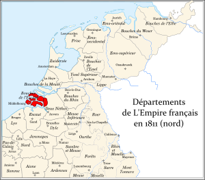
Bouches-de-l'Escaut
Distance: Approx. 2203 meters
Latitude and longitude: 51.4833,3.6
Bouches-de-l'Escaut (French: [buʃ.də.lɛ.sko], "Mouths of the Scheldt"; Dutch: Monden van de Schelde) was a department of the First French Empire in the present-day Netherlands. It was formed in 1810, when the Kingdom of Holland was annexed by France. Its territory corresponded with the present-day Dutch province of Zeeland, minus Zeelandic Flanders, which was part of the department of Escaut.

Oost-Souburg
Town in Zeeland, Netherlands
Distance: Approx. 639 meters
Latitude and longitude: 51.46361111,3.60083333
Oost-Souburg is a town in the municipality of Vlissingen in the province of Zeeland, Netherlands.
Battle of Flushing
1573 battle
Distance: Approx. 1683 meters
Latitude and longitude: 51.45,3.58333333
The Battle of Flushing was a naval battle of the Eighty Years' War, fought on April 17, 1573 near the city of Flushing, Netherlands. The Spanish fleet was led by Sancho d'Avila, the Dutch fleet by Lieven Keersmaker. The Dutch fleet initially left Flushing, but returned when the Spanish fleet was hit by the city's cannons.
Ritthem
Village in Zeeland, Netherlands
Distance: Approx. 2782 meters
Latitude and longitude: 51.45138889,3.62611111
Ritthem is a village in the Dutch province of Zeeland. It is located in the municipality of Vlissingen, about 4 kilometres east of the city.

West-Souburg
Neighbourhood and former village in Vlissingen, Zeeland, Netherlands
Distance: Approx. 106 meters
Latitude and longitude: 51.465,3.59083333
West-Souburg is a neighbourhood of Vlissingen and former village in the Dutch province of Zeeland. It is part of the municipality of Vlissingen, and has been annexed by the city. The village was first mentioned in 1162 as Sutburch, and used to mean "southern fortified place", because it was the most southern of three defensive structures to defend against the Vikings.

Huis der Boede
Dutch country house
Distance: Approx. 2320 meters
Latitude and longitude: 51.47305556,3.56138889
Huis der Boede is a country house near Koudekerke in the Dutch province of Zeeland, erected in 1745 for J. van Mandere, mayor of Vlissingen. For its design, he commissioned the Antwerp architect and sculptor Jan Pieter van Baurscheidt the Younger.

Vlissingen railway station
Terminus railway station in Vlissingen, Netherlands
Distance: Approx. 2249 meters
Latitude and longitude: 51.44416667,3.59583333
Vlissingen (English name: Flushing) is a terminus railway station in Vlissingen, Netherlands. The station opened on 1 September 1873. The station is at the western end of the Roosendaal–Vlissingen railway and has 3 platforms.

Vlissingen Souburg railway station
Railway station in the Netherlands
Distance: Approx. 257 meters
Latitude and longitude: 51.46472222,3.59527778
Vlissingen Souburg (English: Flushing Souburg) is a railway station located in Oost-Souburg, Netherlands. The station was opened on 31 May 1986 and is located on the Roosendaal–Vlissingen railway. It is the westernmost station in the Netherlands.
De Put (restaurant)
Restaurant in Vlissingen, Netherlands
Distance: Approx. 2712 meters
Latitude and longitude: 51.44873611,3.56145278
Restaurant De Put is a defunct restaurant, located in the cellars of the now demolished Strandhotel in Vlissingen, Netherlands. It was a fine dining restaurant that was awarded one Michelin star in both 1964 and 1965. The restaurant closed in 1974, due to dike reinforcement.

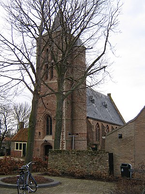
St James the Great Church
Protestant church in the Netherlands
Distance: Approx. 2676 meters
Latitude and longitude: 51.4427,3.5744
Saint James the Great Church is a large Protestant church in the city of Flushing, Netherlands. The building is on the Old Market (Oude Markt); around are the streets called Branderijstraat and Lepelstraat. The original Roman Catholic church of the city, it has belonged to the Dutch Reformed Church since 1572, which became the Protestant Church in the Netherlands in 2004.

Vlissingen train accident
1899 railway incident in the Netherlands
Distance: Approx. 2246 meters
Latitude and longitude: 51.44416667,3.59555556
The Vlissingen train accident took place on 2 June 1899 in Vlissingen, Netherlands when a passenger train derailed upon ramming the buffer stop of the Vlissingen station after their brakes failed to operate properly, resulting in the deaths of 3 people with a further 2 injured.
Weather in this IP's area
broken clouds
13 Celsius
13 Celsius
12 Celsius
13 Celsius
1012 hPa
92 %
1012 hPa
1012 hPa
10000 meters
4.52 m/s
8.8 m/s
193 degree
66 %
08:16:41
18:44:04