193.177.142.231 - IP Lookup: Free IP Address Lookup, Postal Code Lookup, IP Location Lookup, IP ASN, Public IP
Country:
 Netherlands
Region:
City:
Location:
Time Zone:
Postal Code:
ISP:
ASN:
language:
User-Agent:
Proxy IP:
Blacklist:
IP information under different IP Channel
ip-api
Country
Region
City
ASN
Time Zone
ISP
Blacklist
Proxy
Latitude
Longitude
Postal
Route
db-ip
Country
Region
City
ASN
Time Zone
ISP
Blacklist
Proxy
Latitude
Longitude
Postal
Route
IPinfo
Country
Region
City
ASN
Time Zone
ISP
Blacklist
Proxy
Latitude
Longitude
Postal
Route
IP2Location
193.177.142.231Country
nlRegion
noord-holland
City
bloemendaal
Time Zone
Europe/Amsterdam
ISP
Language
User-Agent
Latitude
Longitude
Postal
ipdata
Country
Region
City
ASN
Time Zone
ISP
Blacklist
Proxy
Latitude
Longitude
Postal
Route
Popular places and events near this IP address

Bloemendaal
Municipality and town in North Holland, Netherlands
Distance: Approx. 1533 meters
Latitude and longitude: 52.4,4.6
Bloemendaal (pronounced [ˈblumə(n)ˌdaːl] ) is a municipality and town in the Western Netherlands, in the province of North Holland. Bloemendaal is, together with Wassenaar, the wealthiest place in the Netherlands. It is located just west of Haarlem, on the North Sea.

Overveen
Village in North Holland, Netherlands
Distance: Approx. 1188 meters
Latitude and longitude: 52.39222222,4.6175
Overveen is a village in North Holland in the Netherlands, in the municipality of Bloemendaal. Overveen lies on the eastern fringe of the North Sea dunes. To the east it borders the built-up areas of Haarlem.

Huis ter Kleef
Former castle in Haarlem, Netherlands
Distance: Approx. 1131 meters
Latitude and longitude: 52.396,4.635
The ruins of the Huis ter Kleef castle are located in the city gardens of Haarlem.

Santpoort-Zuid
Village in North Holland, Netherlands
Distance: Approx. 1749 meters
Latitude and longitude: 52.41666667,4.63333333
Santpoort-Zuid (Dutch pronunciation: [ˌsɑntpoːrt ˈsœyt]; Santpoort South) is a village in the municipality of Velsen in the Dutch province of North Holland. It lies to the west of North Haarlem (Schoten). Santpoort-Zuid is bordered by the village of Bloemendaal to the south and the village of Santpoort-Noord to the north.

HC Bloemendaal
Distance: Approx. 1153 meters
Latitude and longitude: 52.41111111,4.61277778
Hockey Club Bloemendaal (Dutch pronunciation: [ˈblumə(n)daːl]), commonly known as Bloemendaal, is a Dutch professional field hockey club based in Bloemendaal, North Holland. It was established on 26 April 1895, and is one of the oldest field hockey clubs in the Netherlands. Originally, the club also played bandy.

Schoten, North Holland
Distance: Approx. 1465 meters
Latitude and longitude: 52.40694444,4.6425
Schoten (Dutch pronunciation: [ˈsxoːtə(n)] ) is a former village in the Dutch province of North Holland. It was located between Haarlem and Santpoort. Schoten was a separate municipality between 1817 and 1927, when it was merged with Haarlem.

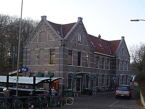
Bloemendaal railway station
Railway station in the Netherlands
Distance: Approx. 405 meters
Latitude and longitude: 52.40416667,4.6275
Bloemendaal railway station is located in Haarlem, on the border of Bloemendaal, the Netherlands. The station was opened on 1 May 1900 on the Haarlem–Uitgeest railway. The station has 2 platforms.
Overveen railway station
Railway station in the Netherlands
Distance: Approx. 1627 meters
Latitude and longitude: 52.39083333,4.60777778
Overveen is a railway station in Overveen, Netherlands. The station opened 3 June 1881. It lies on the Haarlem–Zandvoort railway.

Museum van de Geest
Psychiatry museum in the Netherlands
Distance: Approx. 1724 meters
Latitude and longitude: 52.39027778,4.63777778
Museum van de Geest ("Museum of the Mind") was created in 2020 when Het Dolhuys ("The Madhouse"), the national museum for psychiatry in Haarlem, the Netherlands, merged with the Outsider Art Museum from Amsterdam. Het Dolhuys had been founded in 2005 in the newly renovated former old-age home known as Schoterburcht, located just across the Schotersingel from the Staten Bolwerk park. The whole Het Dolhuys complex is much older, having for centuries been a hospital known as the Leproos-, Pest- en Dolhuys (Leper, Plague, and Mad House).
Chapeau!
Restaurant in Bloemendaal, Netherlands
Distance: Approx. 379 meters
Latitude and longitude: 52.40583333,4.62333333
Chapeau! is a defunct restaurant located in Bloemendaal in the Netherlands. It was a fine dining restaurant that was awarded one Michelin star in the period 2003–2011.

Thijsse's Hof
Distance: Approx. 747 meters
Latitude and longitude: 52.405,4.612
Thijsse's Hof (The garden of Thijsse) is a wildlife garden in Bloemendaal, the Netherlands. It was created in 1925 on the occasion of the 60th birthday of Jac. P. Thijsse, naturalist and nature conservationist.

Schoterveense Molen, Haarlem
Windmill in Haarlem, Netherlands
Distance: Approx. 826 meters
Latitude and longitude: 52.39803056,4.63191667
Schoterveense Molen is a windmill in Haarlem located at Wipwatermolen Heussensstraat in the former municipality of Schoten. It is registered as a Rijksmonument. This windmill stands as silent witness to the heritage of a defunct organization called Waterschap De Schoterveenpolder, that ended in 1935.
Weather in this IP's area
overcast clouds
4 Celsius
4 Celsius
3 Celsius
6 Celsius
1018 hPa
94 %
1018 hPa
1017 hPa
10000 meters
0.89 m/s
2.24 m/s
34 degree
100 %