193.17.250.248 - IP Lookup: Free IP Address Lookup, Postal Code Lookup, IP Location Lookup, IP ASN, Public IP
Country:
Region:
City:
Location:
Time Zone:
Postal Code:
IP information under different IP Channel
ip-api
Country
Region
City
ASN
Time Zone
ISP
Blacklist
Proxy
Latitude
Longitude
Postal
Route
Luminati
Country
Region
71
City
hranice
ASN
Time Zone
Europe/Prague
ISP
O2 Czech Republic, a.s.
Latitude
Longitude
Postal
IPinfo
Country
Region
City
ASN
Time Zone
ISP
Blacklist
Proxy
Latitude
Longitude
Postal
Route
IP2Location
193.17.250.248Country
Region
olomoucky kraj
City
hranice
Time Zone
Europe/Prague
ISP
Language
User-Agent
Latitude
Longitude
Postal
db-ip
Country
Region
City
ASN
Time Zone
ISP
Blacklist
Proxy
Latitude
Longitude
Postal
Route
ipdata
Country
Region
City
ASN
Time Zone
ISP
Blacklist
Proxy
Latitude
Longitude
Postal
Route
Popular places and events near this IP address

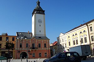
Hranice (Přerov District)
Town in the Czech Republic
Distance: Approx. 2480 meters
Latitude and longitude: 49.5525,17.76833333
Hranice (Czech pronunciation: [ˈɦraɲɪtsɛ]; German: Mährisch Weißkirchen) is a town in Přerov District in the Olomouc Region of the Czech Republic. It has about 18,000 inhabitants. The historic town centre is well preserved and is protected by law as an urban monument zone.

Moravian Gate
Distance: Approx. 4466 meters
Latitude and longitude: 49.58583333,17.75527778
The Moravian Gate (Czech: Moravská brána, Polish: Brama Morawska, German: Mährische Pforte, Slovak: Moravská brána) is a geomorphological feature in the Moravian region of the Czech Republic and the Upper Silesia region in Poland. It is formed by the depression between the Carpathian Mountains in the east and the Sudetes in the west. The drainage divide between the upper Oder river and the Baltic Sea in the north and the Bečva River of the Danube basin runs through it.
Teplice nad Bečvou
Municipality in Olomouc, Czech Republic
Distance: Approx. 2192 meters
Latitude and longitude: 49.52861111,17.74
Teplice nad Bečvou (until 1959 Zbrašov) is a spa municipality and village in Přerov District in the Olomouc Region of the Czech Republic. It has about 500 inhabitants. In addition to the spa, the municipality is known for the Zbrašov Aragonite Caves.
Hrabůvka
Municipality in Olomouc, Czech Republic
Distance: Approx. 4625 meters
Latitude and longitude: 49.57861111,17.69138889
Hrabůvka is a municipality and village in Přerov District in the Olomouc Region of the Czech Republic. It has about 300 inhabitants. Hrabůvka lies approximately 22 kilometres (14 mi) north-east of Přerov, 32 km (20 mi) east of Olomouc, and 241 km (150 mi) east of Prague.

Klokočí (Přerov District)
Municipality in Olomouc, Czech Republic
Distance: Approx. 4029 meters
Latitude and longitude: 49.56027778,17.68222222
Klokočí is a municipality and village in Přerov District in the Olomouc Region of the Czech Republic. It has about 300 inhabitants. Klokočí lies approximately 19 kilometres (12 mi) north-east of Přerov, 31 km (19 mi) east of Olomouc, and 241 km (150 mi) east of Prague.

Milenov
Municipality in Olomouc, Czech Republic
Distance: Approx. 5152 meters
Latitude and longitude: 49.5625,17.66694444
Milenov is a municipality and village in Přerov District in the Olomouc Region of the Czech Republic. It has about 400 inhabitants. Milenov lies approximately 20 kilometres (12 mi) north-east of Přerov, 31 km (19 mi) east of Olomouc, and 240 km (150 mi) east of Prague.

Olšovec
Municipality in Olomouc, Czech Republic
Distance: Approx. 4843 meters
Latitude and longitude: 49.59,17.71722222
Olšovec (German: Olspitz) is a municipality and village in Přerov District in the Olomouc Region of the Czech Republic. It has about 500 inhabitants. Olšovec lies approximately 25 kilometres (16 mi) north-east of Přerov, 34 km (21 mi) east of Olomouc, and 243 km (151 mi) east of Prague.

Ústí (Přerov District)
Municipality in Olomouc, Czech Republic
Distance: Approx. 4172 meters
Latitude and longitude: 49.51666667,17.76638889
Ústí is a municipality and village in Přerov District in the Olomouc Region of the Czech Republic. It has about 500 inhabitants. Ústí lies approximately 24 kilometres (15 mi) east of Přerov, 39 km (24 mi) east of Olomouc, and 249 km (155 mi) east of Prague.
Černotín
Municipality in Olomouc, Czech Republic
Distance: Approx. 3247 meters
Latitude and longitude: 49.53194444,17.77222222
Černotín is a municipality and village in Přerov District in the Olomouc Region of the Czech Republic. It has about 800 inhabitants. Černotín lies approximately 25 kilometres (16 mi) east of Přerov, 39 km (24 mi) east of Olomouc, and 249 km (155 mi) east of Prague.
Špičky
Municipality in Olomouc, Czech Republic
Distance: Approx. 5278 meters
Latitude and longitude: 49.54805556,17.80777778
Špičky (German: Speitsch) is a municipality and village in Přerov District in the Olomouc Region of the Czech Republic. It has about 300 inhabitants. Špičky lies approximately 28 kilometres (17 mi) east of Přerov, 41 km (25 mi) east of Olomouc, and 251 km (156 mi) east of Prague.

Hranice Abyss
Flooded sinkhole near the town of Hranice, Czech Republic
Distance: Approx. 2126 meters
Latitude and longitude: 49.532,17.750778
Hranice Abyss (Czech: Hranická propast) is the deepest flooded pit cave in the world. It is a karst sinkhole near the town of Hranice, Czech Republic. The greatest confirmed depth is 519.5 m (1,704 ft), of which 450 m (1,476 ft) is underwater.
Zbrašov Aragonite Caves
Cave in the Czech Republic
Distance: Approx. 1984 meters
Latitude and longitude: 49.5317,17.7458
The Zbrašov Aragonite Caves (Czech: Zbrašovské aragonitové jeskyně) are a national nature monument in Teplice nad Bečvou in the Olomouc Region, Czech Republic. The main object of its protection is a hydrothermal karst area of European importance. It includes the aragonite caves as well as the surrounding forests.
Weather in this IP's area
broken clouds
2 Celsius
-3 Celsius
-0 Celsius
3 Celsius
1016 hPa
79 %
1016 hPa
984 hPa
10000 meters
5.09 m/s
9.86 m/s
257 degree
81 %


