193.163.140.164 - IP Lookup: Free IP Address Lookup, Postal Code Lookup, IP Location Lookup, IP ASN, Public IP
Country:
 Denmark
Region:
City:
Location:
Time Zone:
Postal Code:
ISP:
ASN:
language:
User-Agent:
Proxy IP:
Blacklist:
IP information under different IP Channel
ip-api
Country
Region
City
ASN
Time Zone
ISP
Blacklist
Proxy
Latitude
Longitude
Postal
Route
db-ip
Country
Region
City
ASN
Time Zone
ISP
Blacklist
Proxy
Latitude
Longitude
Postal
Route
IPinfo
Country
Region
City
ASN
Time Zone
ISP
Blacklist
Proxy
Latitude
Longitude
Postal
Route
IP2Location
193.163.140.164Country
dkRegion
midtjylland
City
skjern
Time Zone
Europe/Copenhagen
ISP
Language
User-Agent
Latitude
Longitude
Postal
ipdata
Country
Region
City
ASN
Time Zone
ISP
Blacklist
Proxy
Latitude
Longitude
Postal
Route
Popular places and events near this IP address

Egvad Municipality
Former municipality in Denmark
Distance: Approx. 4717 meters
Latitude and longitude: 55.90888889,8.51833333
Until 1 January 2007 Egvad was a municipality (Danish: kommune) in Ringkjøbing County near the west coast of the Jutland peninsula in west Denmark. The municipality covered an area of 377 square kilometres [km2] (146 sq mi), and had a total population of 9,396 (2005). Its last mayor was Kent Skaanning.
Skjern Municipality
Distance: Approx. 0 meters
Latitude and longitude: 55.95,8.5
Skjern Municipality is a former municipality (Danish, kommune) in Ringkøbing-Skjern Municipality in Region Midtjylland near the west coast of the Jutland peninsula in west Denmark. The former Skjern municipality covered an area of 327 km2, and had a total population of 13,107 (2005). The city has a population of 7,563 inhabitants.
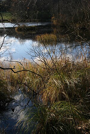
Skjern River
River in Denmark
Distance: Approx. 8167 meters
Latitude and longitude: 55.91666667,8.38333333
Skjern River (Danish: Skjern Å) is the largest river in Denmark, in terms of volume. The river has its spring in Tinnet Krat in central Jutland, very close to Denmark's longest river, the Gudenå. It drains about one tenth of Denmark and flows into the Ringkøbing Fjord - a lagoon and former bay of the North Sea.

Skjern Bank Arena
Danish indoor sports arena
Distance: Approx. 347 meters
Latitude and longitude: 55.95305556,8.50111111
Skjern Bank Arena is an indoor sports arena in Skjern, Denmark primarily used for handball. It is located in the local center Ringkøbing-Skjern Kulturcenter. The arena can seat 2,400 spectators and is home to Danish Handball League team Skjern Håndbold.

Hemmet
Distance: Approx. 5662 meters
Latitude and longitude: 55.9,8.51666667
Hemmet is a small town in the former Egvad Municipality (Danish: Egvad kommune), which since 1 January 2007 has been part of the Ringkøbing-Skjern Municipality, Midtjylland, near the west coast of Jutland in Denmark. Hemmet has a town population of 320 (1. January 2024).

Tarm
Town in Region Midtjylland, Denmark
Distance: Approx. 4991 meters
Latitude and longitude: 55.90666667,8.52055556
Tarm is a small railway town with a population of 4,126 (1 January 2024) in west Denmark, 36 kilometres southwest of Herning (air distance). The road distance between Herning and Tarm is exactly 47.8 kilometres (29.7 mi) (Herning-Videbæk-Skjern-Tarm route). It is located in the Ringkøbing-Skjern Municipality.
Skjern, Denmark
Town in Region Midtjylland, Denmark
Distance: Approx. 323 meters
Latitude and longitude: 55.94777778,8.49666667
Skjern is a railway town just north of the Skjern river in western Jutland, Denmark with a population of 7,839 (1 January 2024). The town was the seat of the former Skjern Municipality, though since 2007 it has been the joint administrative seat of Ringkøbing-Skjern Municipality. The town's expansion in the 19th century was the result of the newly created Skjern railway station.

Skern Runestone
Distance: Approx. 774 meters
Latitude and longitude: 55.94305556,8.49944444
The Skern Runestone, designated as Danish Runic Inscription 81 or DR 81 in the Rundata catalog, is a Viking Age memorial runestone located in the small village of Skjern, Denmark between Viborg and Randers. The stone features a facial mask and a runic inscription which ends in a curse. A fragment of a second runestone designated as DR 80 was also found in Skjern.

Danish Runic Inscription 48
Distance: Approx. 7739 meters
Latitude and longitude: 56.01916667,8.5125
Danish Runic Inscription 48 or DR 48 is the Rundata catalog number for a Viking Age memorial runestone from Hanning, which is about 8 km (5 miles) north of Skjern, Denmark. The runic inscription features a depiction of a hammer, which some have interpreted as a representation of the Norse pagan god Thor, although this interpretation is controversial.
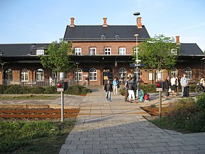
Skjern railway station
Railway station in West Jutland, Denmark
Distance: Approx. 559 meters
Latitude and longitude: 55.9475,8.49222222
Skjern railway station is a railway station serving the town of Skjern in West Jutland, Denmark. The station is located on the West Jutland longitudinal railway line (Danish: Den Vestjyske Længdebane) from Esbjerg to Struer and is the western terminus of the Skanderborg–Skjern railway line from Skanderborg to Skjern. It offers regional train services to Aarhus, Esbjerg, Herning and Holstebro.
Tarm railway station
Railway station in West Jutland, Denmark
Distance: Approx. 4599 meters
Latitude and longitude: 55.91027778,8.52027778
Tarm railway station is a railway station serving the railway town of Tarm in West Jutland, Denmark. Tarm station is located on the Esbjerg–Struer railway line from Esbjerg to Struer. The station opened in 1875.

Battle of Lundenæs
1340 battle in Denmark
Distance: Approx. 4001 meters
Latitude and longitude: 55.95111111,8.56416667
The Battle of Lundenæs (Danish: Slaget ved Lundenæs), also known as the Battle of Skjern River (Danish: Slaget ved Skjern Å) was a military engagement between Holsteinian and Jutish rebel forces on 2 May 1340 possibly at Lundenæs Castle near Skjern River in the then Holsteinian-held Jutland. The battle ended in a Jutish rebel victory and it is alleged that many Germans died in the Skirmish.
Weather in this IP's area
broken clouds
-1 Celsius
-6 Celsius
-1 Celsius
-1 Celsius
1024 hPa
69 %
1024 hPa
1021 hPa
10000 meters
4.12 m/s
40 degree
75 %