193.16.236.82 - IP Lookup: Free IP Address Lookup, Postal Code Lookup, IP Location Lookup, IP ASN, Public IP
Country:
 France
Region:
City:
Location:
Time Zone:
Postal Code:
ISP:
ASN:
language:
User-Agent:
Proxy IP:
Blacklist:
IP information under different IP Channel
ip-api
Country
Region
City
ASN
Time Zone
ISP
Blacklist
Proxy
Latitude
Longitude
Postal
Route
db-ip
Country
Region
City
ASN
Time Zone
ISP
Blacklist
Proxy
Latitude
Longitude
Postal
Route
IPinfo
Country
Region
City
ASN
Time Zone
ISP
Blacklist
Proxy
Latitude
Longitude
Postal
Route
IP2Location
193.16.236.82Country
frRegion
ile-de-france
City
courbevoie
Time Zone
Europe/Paris
ISP
Language
User-Agent
Latitude
Longitude
Postal
ipdata
Country
Region
City
ASN
Time Zone
ISP
Blacklist
Proxy
Latitude
Longitude
Postal
Route
Popular places and events near this IP address

Courbevoie
Commune in Île-de-France, France
Distance: Approx. 277 meters
Latitude and longitude: 48.8978,2.2531
Courbevoie (French pronunciation: [kuʁbəvwa] ) is a commune located in the Hauts-de-Seine department of the Île-de-France region of France. It is a suburb of Paris, 8.2 km (5.1 mi) from the center of Paris. The centre of Courbevoie is situated 2 km (1.2 mi) from the city limits of Paris.

Tour First
Office skyscraper in Courbevoie, in La Défense
Distance: Approx. 937 meters
Latitude and longitude: 48.8889,2.2517
Tour First (previously known as Tour UAP between 1974 and 1998, and as Tour Axa between 1998 and 2007) is an office skyscraper in Courbevoie, in La Défense, the business district of the Paris metropolitan area. The tower was built in 1974 by Bouygues for the UAP insurance company. The building was 159 m (522 ft) at that time.

Tour Les Poissons
42-storey skyscraper in Courbevoie, near La Défense business district, Paris, France
Distance: Approx. 436 meters
Latitude and longitude: 48.8944,2.25167
Tour Les Poissons, known in corporate real estate as Tour Ciel, is a 42-storey, 129.5 m (425 ft) skyscraper located west of Paris in Courbevoie, Hauts-de-Seine, France. While often grouped with the many office towers of La Défense business district, it is actually located half a mile to the northeast in a smaller mixed use complex called Centre Charras, of which it remains the highest building. Completed in 1970, it has occasionally been described as France's first true skyscraper, although Tour Perret in Amiens is more frequently cited.

Tour Eqho
Office in La Défense
Distance: Approx. 875 meters
Latitude and longitude: 48.89222222,2.24666667
Tour Eqho (also known as Tour IBM, and Tour Descartes) is an office skyscraper located in La Défense business district situated west of Paris, France. Built in 1988, the tower, with a height of 130 metres, belongs to the third generation of towers in La Défense. The tower takes the shape of a parallelepiped in which a semi-cylinder would have been extruded on the main façade.
Château de Neuilly
Former French royal palace in Neuilly-sur-Seine, 1751–1848
Distance: Approx. 873 meters
Latitude and longitude: 48.89,2.2627
The château de Neuilly is a former château in Neuilly-sur-Seine, France. Its estate covered a vast 170-hectare park called "parc de Neuilly" which comprised all of Neuilly that is today to be found between avenue du Roule and the town of Levallois-Perret. It was built in 1751, and largely destroyed in 1848, except for one wing which was integrated into a new convent building in 1907.
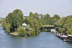
Île de la Jatte
Island in Hauts-de-Seine, France
Distance: Approx. 895 meters
Latitude and longitude: 48.89555556,2.26861111
The Île de la Jatte (French pronunciation: [il də la ʒat]) or Île de la Grande Jatte ([- ɡʁɑ̃d ʒat]) is an island in the river Seine, located in the department of Hauts-de-Seine, and shared between the two communes of Neuilly-sur-Seine and Levallois. It is situated at the very gates of Paris, being 7 km distant (in a straight line) from the towers of Notre Dame and 3 km from the Place de l'Étoile. The island, which has about 4,000 inhabitants, is nearly 2 km long and almost 200 m wide at its widest point.
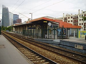
Courbevoie station
Railway station in Hauts-de-Seine department, France
Distance: Approx. 605 meters
Latitude and longitude: 48.89833333,2.24861111
Courbevoie is a railway station serving the town Courbevoie, Hauts-de-Seine department, in the western suburbs of Paris, France. It is served by Transilien Line L services between Paris Gare Saint-Lazare and Gare de Saint-Cloud.

EDC Paris Business School
Business school in Paris, France
Distance: Approx. 789 meters
Latitude and longitude: 48.89,2.253
EDC Paris Business School, also called Ecole des Dirigeants et des Créateurs d'entreprise, is a French business School in the city of Paris located in the business district La Défense. It offers four complete programs in English at undergraduate, graduate and post graduate levels (luxury brand management) Its MBA Luxury Brand Marketing and International Management is ranked 9th worldwide by Eduniversal. In partnership with the jewellery house Cartier, EDC created Sup de Luxe, a school offering programmes in luxury management.

Lycée Paul Lapie
Senior high school in France
Distance: Approx. 423 meters
Latitude and longitude: 48.9005,2.2564
Lycée Paul Lapie is a French senior high school/sixth-form college in Courbevoie, Hauts-de-Seine, France, in the Paris metropolitan area. The school building, designed by Florent Nanquette, opened in the fall of 1933. The school's design plans had been made in 1930.
Canton of Courbevoie-1
Administrative division of Hauts-de-Seine, France
Distance: Approx. 448 meters
Latitude and longitude: 48.9,2.26
The canton of Courbevoie-1 is an administrative division of the Hauts-de-Seine department, in northern France. It was created at the French canton reorganisation which came into effect in March 2015. Its seat is in Courbevoie.
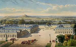
Centre Charras
Distance: Approx. 320 meters
Latitude and longitude: 48.89525,2.25272222
Complexe Urbain Charras, promoted in real estate as Zodiaque and commonly called Centre Charras, is a former military garrison site and current residential and entertainment district in Courbevoie, Hauts-de-Seine, France.

Hôtel de Ville, Courbevoie
Town hall in Courbevoie, France
Distance: Approx. 170 meters
Latitude and longitude: 48.8952,2.2561
The Hôtel de Ville (French pronunciation: [otɛl də vil], City Hall) is a municipal building in Courbevoie, Hauts-de-Seine in the northwestern suburbs of Paris, France, standing on Rue de l'Hôtel de Ville. It was designated a monument historique by the French government in 1980.
Weather in this IP's area
light intensity drizzle
5 Celsius
2 Celsius
4 Celsius
6 Celsius
1016 hPa
86 %
1016 hPa
1006 hPa
10000 meters
4.12 m/s
70 degree
75 %