Country:
 Switzerland
Region:
City:
Latitude and Longitude:
Time Zone:
Postal Code:
IP information under different IP Channel
ip-api
Country
Region
City
ASN
Time Zone
ISP
Blacklist
Proxy
Latitude
Longitude
Postal
Route
IPinfo
Country
Region
City
ASN
Time Zone
ISP
Blacklist
Proxy
Latitude
Longitude
Postal
Route
MaxMind
Country
Region
City
ASN
Time Zone
ISP
Blacklist
Proxy
Latitude
Longitude
Postal
Route
Luminati
Country
CHASN
Time Zone
Europe/Zurich
ISP
BSE Software GmbH
Latitude
Longitude
Postal
db-ip
Country
Region
City
ASN
Time Zone
ISP
Blacklist
Proxy
Latitude
Longitude
Postal
Route
ipdata
Country
Region
City
ASN
Time Zone
ISP
Blacklist
Proxy
Latitude
Longitude
Postal
Route
Popular places and events near this IP address

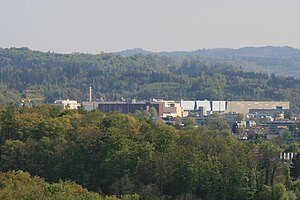
Aarau
Municipality in Aargau, Switzerland
Distance: Approx. 1332 meters
Latitude and longitude: 47.4,8.05
Aarau (Swiss Standard German: [ˈaːraʊ], Alemannic German pronunciation: [ˈɑːræu̯]) is a town, a municipality, and the capital of the northern Swiss canton of Aargau. The town is also the capital of the district of Aarau. It is German-speaking and predominantly Protestant.
Buchs, Aargau
Municipality in Aargau, Switzerland
Distance: Approx. 1872 meters
Latitude and longitude: 47.38333333,8.08333333
Buchs (German pronunciation: [bʊks] ) is a municipality in the district of Aarau of the canton of Aargau in Switzerland. It is located near the river Suhre and borders with the municipalities of Aarau, Rupperswil and Suhr. The municipality is accessed by the A1 motorway via the Aarau-Ost exit.

Stadion Brügglifeld
Distance: Approx. 812 meters
Latitude and longitude: 47.38333333,8.06
Stadion Brügglifeld is a multi-purpose stadium in Aarau, Switzerland. It is primarily used for football matches and is the home stadium of FC Aarau. The current capacity is 9,249 seats, which include 1499 covered seats.

Rohr, Aargau
Former municipality in Aargau, Switzerland
Distance: Approx. 1986 meters
Latitude and longitude: 47.4,8.08333333
Until the first of January 2010 Rohr was a municipality in the district of Aarau in the canton of Aargau in Switzerland. At the beginning of 2010 Rohr became a suburb of Aarau.

Suhre
Tributary of the river Aare
Distance: Approx. 1724 meters
Latitude and longitude: 47.4057,8.066
The river Suhre is a 34 kilometer long tributary of the river Aare in the Swiss cantons of Lucerne and Aargau. The river rises in Sempachersee (or Lake Sempach) at an elevation of 504 meters above sea level, and joins the Aare east of the town Aarau at an elevation of 362 meters. The most important side valley is the Ruedertal, which joins the Suhretal (or Suhre Valley) at Schöftland.

Aarau railway station
Railway station in Aargau, Switzerland
Distance: Approx. 734 meters
Latitude and longitude: 47.39135,8.05125111
Aarau railway station (German: Bahnhof Aarau) serves the municipality of Aarau, capital town of the canton of Aargau, Switzerland. Opened in 1856, it is owned and operated by Swiss Federal Railways (SBB CFF FFS). The station forms the junction between the Olten–Aarau railway, the Zurich-Aarau railway and the Baden–Aarau railway.

Aargauische Kantonalbank
Distance: Approx. 858 meters
Latitude and longitude: 47.3914,8.0496
Aargauische Kantonalbank is a cantonal bank based in the canton of Aargau, Switzerland. Its head office is situated at Aarau (AG).

Old Cantonal School Aarau
School in Aargau / Argovia, Switzerland
Distance: Approx. 682 meters
Latitude and longitude: 47.3933,8.0528
The old cantonal school of Aarau (in German: AKSA, Alte Kantonsschule Aarau or Alte Kanti) was founded in 1802 and is the oldest non-church secondary school in Switzerland.

Aarau WSB railway station
Railway station in Switzerland
Distance: Approx. 622 meters
Latitude and longitude: 47.39097222,8.05269444
Aarau WSB railway station (German: Bahnhof Aarau WSB) is a railway station in the municipality of Aarau, the capital city of the Swiss canton of Aargau. It is the principal intermediate point on the 1,000 mm (3 ft 3+3⁄8 in) gauge Schöftland–Aarau–Menziken line of Aargau Verkehr. The station is the main point of transfer to the Swiss Federal Railways (SBB) lines, and is situated across Hintere Bahnhofstrasse from the south side of the SBB station.
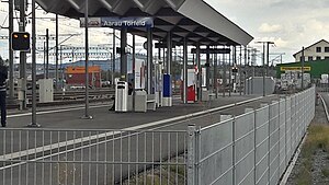
Aarau Torfeld railway station
Railway station in Switzerland
Distance: Approx. 353 meters
Latitude and longitude: 47.39356,8.06262111
Aarau Torfeld railway station (German: Bahnhof Aarau Torfeld) is a railway station in the municipality of Aarau, in the Swiss canton of Aargau. It is an intermediate stop on the 1,000 mm (3 ft 3+3⁄8 in) gauge Schöftland–Aarau–Menziken line of Aargau Verkehr. The station opened on 10 December 2017.

Buchs AG railway station
Railway station in Switzerland
Distance: Approx. 687 meters
Latitude and longitude: 47.39,8.07
Buchs AG railway station (German: Bahnhof Buchs AG) is a railway station in the municipality of Buchs, in the Swiss canton of Aargau (abreviated to AG). It is an intermediate stop on the 1,000 mm (3 ft 3+3⁄8 in) gauge Schöftland–Aarau–Menziken line of Aargau Verkehr.

Aargauer Kunsthaus
Swiss art museum and natural history museum
Distance: Approx. 1215 meters
Latitude and longitude: 47.390965,8.044816
The Aargauer Kunsthaus (English: Aargau Art House) is a Swiss art museum founded in 1959, and located in Aarau. The museum collection includes Swiss art from the 18th century to the present day; and Naturama, a natural history collection.
Weather in this IP's area
light rain
14 Celsius
14 Celsius
13 Celsius
15 Celsius
1006 hPa
97 %
1006 hPa
961 hPa
10000 meters
2.1 m/s
4.89 m/s
204 degree
100 %
07:36:31
18:53:37