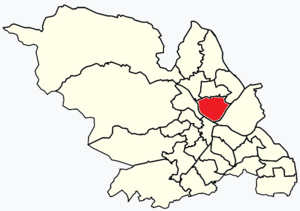
Country:
 Great Britain
Region:
City:
Latitude and Longitude:
Time Zone:
Postal Code:
IP information under different IP Channel
ip-api
Country
Region
City
ASN
Time Zone
ISP
Blacklist
Proxy
Latitude
Longitude
Postal
Route
IPinfo
Country
Region
City
ASN
Time Zone
ISP
Blacklist
Proxy
Latitude
Longitude
Postal
Route
MaxMind
Country
Region
City
ASN
Time Zone
ISP
Blacklist
Proxy
Latitude
Longitude
Postal
Route
Luminati
Country
GBASN
Time Zone
Europe/London
ISP
Kda Web Services Ltd
Latitude
Longitude
Postal
db-ip
Country
Region
City
ASN
Time Zone
ISP
Blacklist
Proxy
Latitude
Longitude
Postal
Route
ipdata
Country
Region
City
ASN
Time Zone
ISP
Blacklist
Proxy
Latitude
Longitude
Postal
Route
Popular places and events near this IP address
Sheffield Wicker railway station
Disused railway station in South Yorkshire, England
Distance: Approx. 403 meters
Latitude and longitude: 53.38972,-1.45834
Wicker railway station (later Wicker Goods railway station) was the first railway station to be built in Sheffield, England. It was to the north of the city centre, at the northern end of the Wicker, in the fork formed by Spital Hill and Savile Street. It was opened on 31 October 1838 as the southern terminus of the Sheffield and Rotherham Railway, which ran north to Rotherham Westgate railway station.
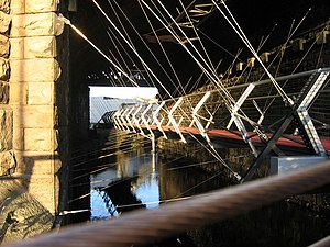
Cobweb Bridge
Bridge in Sheffield, South Yorkshire, England
Distance: Approx. 568 meters
Latitude and longitude: 53.38797222,-1.46002778
The Cobweb Bridge, also known as Spider Bridge, is located in the city centre of Sheffield, South Yorkshire, England, near the disused Sheffield Victoria railway station. Completed in 2002, its design solves a difficult problem: passing the riverside cycle- and footpath (the Five Weirs Walk) under the massive Wicker Arches viaduct while linking one bank of the River Don to the other. Without the Cobweb Bridge, the footpath would have had to make a one-mile detour.

Wicker Arches
Railway viaduct in South Yorkshire, England
Distance: Approx. 613 meters
Latitude and longitude: 53.3883,-1.461
Wicker Arches form a 660-yard (600 m) long railway viaduct across the Don Valley in the City of Sheffield, England. They take their name from the thoroughfare Wicker, which passes through the main arch of the viaduct and was, until the completion of the Sheffield Parkway, the main route eastwards from the city to the M1. It is a Grade II* listed structure.

Sheffield Victoria railway station
Disused railway station in South Yorkshire, England
Distance: Approx. 524 meters
Latitude and longitude: 53.38747,-1.45876
Sheffield Victoria was the main railway station in Sheffield, South Yorkshire, England, on the Great Central Railway,
Burngreave (ward)
Electoral ward in the City of Sheffield, South Yorkshire, England
Distance: Approx. 387 meters
Latitude and longitude: 53.391,-1.458
Burngreave ward—which includes the districts of Burngreave, Fir Vale, Grimesthorpe, Pitsmoor, and Shirecliffe—is one of the 28 electoral wards in City of Sheffield, England. It is located in the northern part of the city and covers an area of 2.8 square miles (7.3 km2; 1,800 acres). The population of this ward in 2011 was 27,481 people in 9,906 households.

Sheffield urban area
Conurbation in the north of England
Distance: Approx. 563 meters
Latitude and longitude: 53.395,-1.455
The Sheffield Urban Area is a conurbation in the north of England with a population of 685,368 according to the 2011 census. This was a 7% increase on the 2001 population of 640,720 making it the 8th largest conurbation in the United Kingdom and England's 6th largest. Named the Sheffield Urban Area by the Office for National Statistics, it must not be confused with the Sheffield City Region, a non-government term, although often used, particularly by the business community.
Attercliffe Road railway station
Disused railway station in South Yorkshire, England
Distance: Approx. 189 meters
Latitude and longitude: 53.38914,-1.45011
Attercliffe Road railway station is a former railway station in Sheffield, South Yorkshire, England. The station served the communities of Attercliffe, Burngreave and workers in the Don Valley and was situated on the Midland Main Line near Attercliffe Road, lying between Sheffield railway station and Brightside railway station.
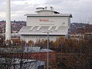
Sheffield Energy Recovery Facility
Distance: Approx. 409 meters
Latitude and longitude: 53.3866,-1.4511
The Sheffield Energy Recovery Facility, also known as the Energy from Waste Plant, is a modern incinerator which treats Sheffield's household waste. It is notable as it not only provides electricity from the combustion of waste but also supplies heat to a local district heating scheme, making it one of the most advanced, energy efficient incineration plants in the UK. In 2004, the district heating network prevented 15,108 tonnes of CO2 from being released from buildings across the city, compared to energy derived from fossil fuels. The incinerator is a 'static asset' owned by Sheffield City Council and operated by Veolia Environmental Services under a 35 year integrated waste management contract (IWMC)/PFI contract.

The Wicker
Arterial street in Sheffield, England
Distance: Approx. 734 meters
Latitude and longitude: 53.387,-1.462
The Wicker is an arterial street in Sheffield, England noted for its history and viaduct that crosses it, the Grade II* listed Wicker Arches. It runs in a north-east to south-westerly direction between Lady's Bridge and the Wicker Arches. For many years the Wicker was an A road, but it has been downgraded following the opening of the Sheffield Northern Relief Road.
Burngreave
District of Sheffield South Yorkshire, England
Distance: Approx. 100 meters
Latitude and longitude: 53.391,-1.453
Burngreave is an inner city district of Sheffield, South Yorkshire, England lying north of the city centre. The population of the ward taken at the 2011 census was 27,481. It started to develop in the second half of the 19th century.
Burngreave Community Radio
Radio station
Distance: Approx. 426 meters
Latitude and longitude: 53.391274,-1.458489
Burngreave Community Radio, also known as BCR103.1FM or simply BCR is a community radio station based in Burngreave, Sheffield, England. The pre-decessor of BCR was Pure Community Music (PCM) broadcast around March–April 2001 on medium wave (1413AM kHz, through a Restricted Service Licence (RSL) broadcast. BCR is Sheffield's newest major radio station, and can be accessed in the local area on 103.1FM or by streaming over the web.

East House mass shooting
1960 mass shooting in Sheffield, England
Distance: Approx. 432 meters
Latitude and longitude: 53.3906,-1.4588
On New Year's Day 1960, three men were shot and killed and two wounded in a mass shooting at the East House public house in Sheffield, England. The killer was Mohamed Ismail, a Somali, who had earlier expressed a desire to end his life but thought that suicide was not an option due to his religious beliefs. He committed the shooting in the hope that he would be arrested and sentenced to death by a British court.
Weather in this IP's area
scattered clouds
13 Celsius
12 Celsius
12 Celsius
15 Celsius
995 hPa
51 %
995 hPa
989 hPa
10000 meters
1.65 m/s
2.21 m/s
136 degree
27 %
07:18:28
18:28:21