Country:
Region:
City:
Latitude and Longitude:
Time Zone:
Postal Code:
IP information under different IP Channel
ip-api
Country
Region
City
ASN
Time Zone
ISP
Blacklist
Proxy
Latitude
Longitude
Postal
Route
Luminati
Country
Region
wal
City
plancenoit
ASN
Time Zone
Europe/Brussels
ISP
Telenet BV
Latitude
Longitude
Postal
IPinfo
Country
Region
City
ASN
Time Zone
ISP
Blacklist
Proxy
Latitude
Longitude
Postal
Route
db-ip
Country
Region
City
ASN
Time Zone
ISP
Blacklist
Proxy
Latitude
Longitude
Postal
Route
ipdata
Country
Region
City
ASN
Time Zone
ISP
Blacklist
Proxy
Latitude
Longitude
Postal
Route
Popular places and events near this IP address
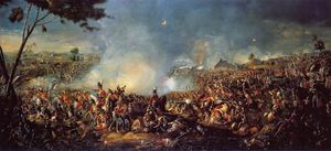
Battle of Waterloo
1815 battle of the Napoleonic Wars
Distance: Approx. 1754 meters
Latitude and longitude: 50.67805556,4.41222222
The Battle of Waterloo (Dutch: [ˈʋaːtərloː] ) was fought on Sunday 18 June 1815, near Waterloo (at that time in the United Kingdom of the Netherlands, now in Belgium), marking the end of the Napoleonic Wars. A French army under the command of Napoleon was defeated by two armies of the Seventh Coalition. One of these was a British-led force with units from the United Kingdom, the Netherlands, Hanover, Brunswick, and Nassau, under the command of Arthur Wellesley, Duke of Wellington (often referred to as the Anglo-allied army or Wellington's army).

La Belle Alliance
Inn near the battlefield of Waterloo
Distance: Approx. 1084 meters
Latitude and longitude: 50.66833333,4.41361111
La Belle Alliance is an inn situated a few miles south of Brussels in Belgium, chiefly remembered for its significance in the aftermath of the Battle of Waterloo (18 June 1815). There are two plaques on the building: one is "In memory of the French Medical Corps who attended the wounded with devotion on 18 June 1815"; and the other commemorates the meeting of the two victorious field marshals at the end of the Battle of Waterloo.
Plancenoit
Distance: Approx. 620 meters
Latitude and longitude: 50.66066111,4.42951111
Plancenoit (French pronunciation: [plɑ̃snwa]; Walloon: Planchenois) is a village of Wallonia and a district of the municipality of Lasne, located in the province of Walloon Brabant, Belgium. The hamlet of Marache is on its territory. The village was a key strategic point during the Battle of Waterloo as it was the main focal point of the Prussians' successful flank attack on Napoleon's army.
Lion's Mound
War memorial in Braine-l'Alleud, Wallonia, Belgium
Distance: Approx. 2159 meters
Latitude and longitude: 50.67833333,4.40472222
The Lion's Mound (French: Butte du Lion, lit. "Lion's Hillock/Knoll"; Dutch: Leeuw van Waterloo, lit. "Lion of Waterloo") is a large conical artificial hill in the municipality of Braine-l'Alleud, Walloon Brabant, Belgium.

Panorama of the Battle of Waterloo
Painting by Louis Dumoulin in a rotunda by Franz Van Ophem
Distance: Approx. 2189 meters
Latitude and longitude: 50.67916667,4.40527778
The Panorama of the Battle of Waterloo (French: Panorama de la Bataille de Waterloo) is a rotunda in Belgium that houses a monumental panoramic painting depicting the Battle of Waterloo. The neoclassical building is located immediately to the north of the Lion's Mound on the battlefield of the Battle of Waterloo in the municipality of Braine-l'Alleud in the Belgian province of Walloon Brabant.
Papelotte
Military stronghold at the Battle of Waterloo
Distance: Approx. 1611 meters
Latitude and longitude: 50.68027778,4.43388889
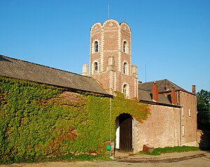
Papelotte Farm (French: Ferme de la Papelotte) is located at Rue Du Dimont a rural road in the Municipality of Braine-l'Alleud around 15 km (9.3 mi) south of Brussels, Belgium. On June 18, 1815, during the pivotal Battle of Waterloo it served as one of the advanced defensible positions of the Anglo-allied army under the command of the Duke of Wellington. Along with the walled farm compounds of Hougoumont and La Haye Sainte, it proved to be instrumental to the delay and the disruption of the opposing Napoleonic army's progress on the battlefield.

Frischermont
Distance: Approx. 1715 meters
Latitude and longitude: 50.67763,4.4449
Châteaux Frischermont or Fichermont in the Belgian municipality of Lasne is now a ruin (destroyed by fire in and demolished in 1965). At the start of the Battle of Waterloo in 1815 it was garrisoned by Dutch soldiers on the easternmost flank of Wellington's defensive line. In 1705 the Châteaux was for a time the headquarters of the Duke of Marlborough.
Marache
Distance: Approx. 1892 meters
Latitude and longitude: 50.68073,4.44252
Marache, or historically Smohain, is hamlet of Wallonia in the municipalities of Lasne, district of Plancenoit, and Waterloo, in the province of Walloon Brabant, Belgium. It is located in a defile through which runs the Smohain, a stream that rises just to the west of the hamlet. Smohain, along with the two farms of Papelotte and La Haye (which are located on the northern bank closer to the head of the same valley about 600 metres (660 yd) and 430 metres (470 yd) west of the centre of the hamlet) and the now ruined Château Fichermont (on a premonitory 350 metres (380 yd) south of the hamlet) formed the eastern bulwark of the Duke of Wellington's Anglo-allied line during the Battle of Waterloo on 18 June 1815.
La Haye, Lasne
Distance: Approx. 1673 meters
Latitude and longitude: 50.68043,4.43622
La Haye was a farm, in a hamlet of the same name, in the Belgian municipality of Lasne. It was destroyed by fire in 1910. During the Battle of Waterloo (18 June 1815) the farm was one of the fortified garrisoned points that made up a bulwark on the extreme left (eastern end) of the Duke of Wellington's Anglo-allied line.

Waterloo Elm
Distance: Approx. 1959 meters
Latitude and longitude: 50.68016111,4.41168889
The Waterloo Elm was located just south west of the intersection of the sunken lane and the Genappe–Brussels main road. It was the Duke of Wellington's command post for much of the Battle of Waterloo (18 June 1815). The tree was killed by souvenir hunters after the battle.

Decoster's house
Distance: Approx. 1070 meters
Latitude and longitude: 50.66408889,4.41381111
Decoster's house was a landmark location during the Battle of Waterloo. It stood on the eastern side of the Waterloo–Genappe main road south of the junction with the minor road to Plancenoit (south La Belle Alliance and north the farm of Rossomme). According to Jean-Baptiste Decoster Napoleon spent the early part of the Battle of Waterloo and around Rossomme and then at about 17:00 moved to a position near Decoster's house where he remained until about 19:00.
Gordon Monument
Memorial of the Battle of Waterloo
Distance: Approx. 1896 meters
Latitude and longitude: 50.67958,4.41197
The Gordon Monument is a neoclassical monument to a slain warrior on the battlefield of Waterloo. The person commemorated is Lt Colonel Sir Alexander Gordon (1786–1815). It was erected in 1817 by the siblings of the deceased who included a future Prime Minister, Lord Aberdeen.
Weather in this IP's area
light rain
11 Celsius
10 Celsius
10 Celsius
11 Celsius
994 hPa
95 %
994 hPa
980 hPa
10000 meters
5.81 m/s
13.41 m/s
257 degree
100 %
08:04:31
16:51:18


