Country:
Region:
City:
Latitude and Longitude:
Time Zone:
Postal Code:
IP information under different IP Channel
ip-api
Country
Region
City
ASN
Time Zone
ISP
Blacklist
Proxy
Latitude
Longitude
Postal
Route
Luminati
Country
ASN
Time Zone
Europe/Madrid
ISP
Asociacion Espanix
Latitude
Longitude
Postal
IPinfo
Country
Region
City
ASN
Time Zone
ISP
Blacklist
Proxy
Latitude
Longitude
Postal
Route
db-ip
Country
Region
City
ASN
Time Zone
ISP
Blacklist
Proxy
Latitude
Longitude
Postal
Route
ipdata
Country
Region
City
ASN
Time Zone
ISP
Blacklist
Proxy
Latitude
Longitude
Postal
Route
Popular places and events near this IP address
Pozuelo de Alarcón
Place in Community of Madrid, Spain
Distance: Approx. 7921 meters
Latitude and longitude: 40.43611111,-3.81388889
Pozuelo de Alarcón (Spanish pronunciation: [poˈθwelo ðe alaɾˈkon]) is a municipality in the Community of Madrid, Spain. Bordering the Moncloa-Aravaca district of Madrid proper to its west, Pozuelo de Alarcón is surrounded by large Mediterranean pine-tree forests: the Casa de Campo, the Monte del Pardo, and the Monte del Pilar. As of 2022, it ranks as the wealthiest municipality in Spain.
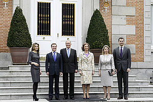
Palace of Zarzuela
Private residence of the Spanish royal family in Madrid, Spain
Distance: Approx. 6321 meters
Latitude and longitude: 40.48325,-3.80165
The Zarzuela Palace (Spanish: Palacio de la Zarzuela [paˈlaθjo ðe la θaɾˈθwela]) is the residence and working offices of the reigning monarch of Spain (King Felipe VI), although the official residence of the Spanish royal family is the Royal Palace of Madrid. The Zarzuela Palace is on the outskirts of Madrid, near the Royal Palace of El Pardo, which accommodates visiting heads of state. The palace is owned by the Spanish government and administered by a state agency named Patrimonio Nacional (National Heritage).
Las Rozas de Madrid
Place in Community of Madrid, Spain
Distance: Approx. 331 meters
Latitude and longitude: 40.49166667,-3.87333333
Las Rozas de Madrid (Spanish: [las ˈɾoθas ðe maˈðɾið] , or simply, Las Rozas [las ˈɾoθas]) is a municipality in the autonomous community of Madrid, Spain, with an area of 59 km² (22¾ sq. mi.).[1] The municipality is served by three Renfe railway stations– Las Rozas, Pinar de Las Rozas and Las Matas. Additional stops at Peñascales and El Tejar were closed.
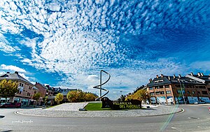
Villanueva del Pardillo
Municipality in Community of Madrid, Spain
Distance: Approx. 7717 meters
Latitude and longitude: 40.48333333,-3.96666667
Villanueva del Pardillo is a municipality and Spanish town of the Community of Madrid, situated 26 kilometers from the capital of Spain and nestled in the natural environment of the Cuenca del Guadarrama. It borders the municipalities of Majadahonda, Las Rozas de Madrid, Villanueva de la Cañada, Galapagar, Colmenarejo and Valdemorillo.

Francisco de Vitoria University
University in Spain
Distance: Approx. 6513 meters
Latitude and longitude: 40.4396,-3.8355
Francisco de Vitoria University (Spanish: Universidad Francisco de Vitoria) is a private university located in Pozuelo de Alarcón, in the Community of Madrid, Spain. It is a Roman Catholic institution run by the Legion of Christ. It is named after Francisco de Vitoria (c. 1483 – 1546), a Spanish philosopher, theologian, and jurist.
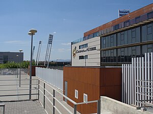
La Ciudad del Fútbol
Distance: Approx. 4400 meters
Latitude and longitude: 40.524,-3.901
La Ciudad del Fútbol de la Real Federación Española de Fútbol (English: The Football City of the Royal Spanish Football Federation) is a football training facility opened in 2003, serving as the headquarters of the Royal Spanish Football Federation as well as the official training centre of the Spanish football team. It is located in the municipality of Las Rozas de Madrid around 20 km northwest of the capital Madrid, within the Community of Madrid.
First Battle of the Corunna Road
Distance: Approx. 7487 meters
Latitude and longitude: 40.44083333,-3.81472222
The First Battle of the Corunna Road took place between 29 November and 3 December 1936 during the Spanish Civil War. The Nationalists tried to isolate Madrid from the west, cutting the Corunna Road, but the Republican army repelled the attack.
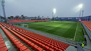
Estadio Cerro del Espino
Distance: Approx. 3789 meters
Latitude and longitude: 40.4575,-3.86027778
The Mini Estadio Cerro del Espino is a multi-use stadium located in Majadahonda, Community of Madrid, Spain. It holds 3800 spectators. It is currently used for football matches and is the home stadium of Atlético Madrid reserve teams and CF Rayo Majadahonda.

Colegio Japonés de Madrid
Japanese international school in Spain
Distance: Approx. 4330 meters
Latitude and longitude: 40.4727916,-3.8296338
The Colegio Japonés de Madrid (CJM) (マドリッド日本人学校, Madoriddo Nihonjin Gakkō, Spanish: "Japanese College of Madrid") is a Japanese international school in the El Plantío area of Moncloa-Aravaca, Madrid, in the city's northwestern portion. Many Japanese families, particularly those with children, live in northwest Madrid, in proximity to the school. It was established on 1 September 1981 (Shōwa 56).
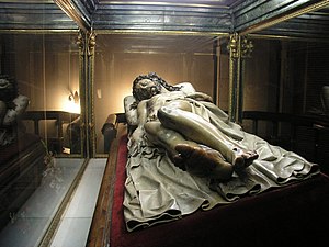
Cristo Yacente of El Pardo
Image of the dead Christ
Distance: Approx. 8071 meters
Latitude and longitude: 40.51903611,-3.78885
The Cristo Yacente (Dead Christ) of El Pardo, is a life-size polychromed sculpture by Spanish sculptor Gregorio Fernández, executed between 1614 and 1615. Housed in a chapel of the Capuchin Monastery of El Pardo (Madrid), the sculpture was commissioned by King Philip III to celebrate the birth of his son Philip IV. The Cristo yacente of El Pardo is the most famous of the fourteen "Cristos" produced by Fernández and his workshop. As devotional images, many of them were processed during Holy Week with other “pasos” (elaborate religious floats adorned with sculptures depicting scenes from the Passion of Christ).
Ciudad Deportiva Atlético de Madrid
Distance: Approx. 3660 meters
Latitude and longitude: 40.45916667,-3.85888889
Ciudad Deportiva Atlético de Madrid, officially Ciudad Civitas Deportiva Atlético de Madrid is the training ground and academy base of Spanish football club Atlético Madrid. It was officially opened on 13 September 1995. Located in Majadahonda and covering 55,000 m2 it is used since 1995 for youth and senior team trainings.

El Plantío
Ward of Madrid in Spain
Distance: Approx. 4736 meters
Latitude and longitude: 40.4708,-3.82556111
El Plantío is a ward (barrio) of Madrid belonging to the district of Moncloa-Aravaca. The Colegio Japonés de Madrid, a Japanese international school, is in El Plantío.
Weather in this IP's area
overcast clouds
13 Celsius
12 Celsius
12 Celsius
13 Celsius
1020 hPa
81 %
1020 hPa
936 hPa
10000 meters
3.09 m/s
100 degree
100 %
08:02:15
17:58:18

