Country:
 Finland
Region:
City:
Latitude and Longitude:
Time Zone:
Postal Code:
IP information under different IP Channel
ip-api
Country
Region
City
ASN
Time Zone
ISP
Blacklist
Proxy
Latitude
Longitude
Postal
Route
IPinfo
Country
Region
City
ASN
Time Zone
ISP
Blacklist
Proxy
Latitude
Longitude
Postal
Route
MaxMind
Country
Region
City
ASN
Time Zone
ISP
Blacklist
Proxy
Latitude
Longitude
Postal
Route
Luminati
Country
FIRegion
19
City
turku
ASN
Time Zone
Europe/Helsinki
ISP
Elisa Oyj
Latitude
Longitude
Postal
db-ip
Country
Region
City
ASN
Time Zone
ISP
Blacklist
Proxy
Latitude
Longitude
Postal
Route
ipdata
Country
Region
City
ASN
Time Zone
ISP
Blacklist
Proxy
Latitude
Longitude
Postal
Route
Popular places and events near this IP address
Turku and Pori Province
Province of Finland (1634–1997)
Distance: Approx. 335 meters
Latitude and longitude: 60.4517,22.27
Turku and Pori Province (Finnish: Turun ja Porin lääni, Swedish: Åbo och Björneborgs län, Russian: Або-Бьёрнеборгская губерния) was a province of independent Finland from 1917 to 1997. The province was however founded as a county in 1634 when today's Finland was an integrated part of Sweden. It is named after the cities of Turku (Swedish: Åbo) and Pori (Swedish: Björneborg).

Aboa Vetus & Ars Nova
Distance: Approx. 210 meters
Latitude and longitude: 60.44972222,22.27361111
Aboa Vetus and Ars Nova is a museum in central Turku, Finland. The museum is housed in a building known as the Rettig palace, originally built in 1928. The archaeological section Aboa Vetus (Latin for Old Turku) displays portions of the city dating back to medieval times, while Ars Nova (Latin for New Art) is a museum of contemporary art.
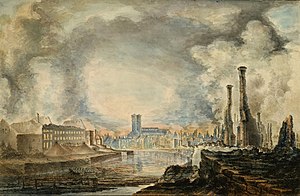
Great Fire of Turku
1827 conflagration in Turku, Finland
Distance: Approx. 146 meters
Latitude and longitude: 60.45,22.27
The Great Fire of Turku (Finnish: Turun palo, Swedish: Åbo brand and Russian: Пожар Або) was a conflagration in the city of Turku in 1827. It is still the largest urban fire in the history of Finland and the Nordic countries. The city had faced several large fires before, including an especially devastating one in 1681.

Turku City Library
Distance: Approx. 277 meters
Latitude and longitude: 60.45111111,22.27166667
Turku City Library (Finnish: Turun kaupunginkirjasto, Swedish: Åbo stadsbibliotek) is a municipal public library in Turku. The Main Library is located in the VI District at the city centre. The Turku City Library also operates several branch libraries and two mobile libraries.

Panimoravintola Koulu
Distance: Approx. 332 meters
Latitude and longitude: 60.44972222,22.26472222
Panimoravintola Koulu is a Finnish brewery restaurant in the city of Turku. Koulu (Finnish for "school") is the largest brewery restaurant in Finland and it is situated in a former Neo-Renaissance style school building from 1889 by architects L. I. Lindqvist and Bruno Granholm. The school to first occupy the building was "Svenska Fruntimmerskolan i Åbo", which was later renamed as the "Svenska flickskolan i Åbo" in 1916, again in 1955 when it became "Åbo svenska flicklyseum", until finally in 1966 the name was changed to "Cygnaeus skola".
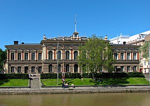
Turku City Hall
Building in Finland
Distance: Approx. 101 meters
Latitude and longitude: 60.4489,22.2686
Turku City Hall (Finnish: Turun kaupungintalo, Swedish: Åbo stadshus) is a Neo-Renaissance building on the bank of the Aura River in Turku, Finland. The City Council of Turku convenes there. The mayor worked in an Art Nouveau building near the City Hall, the Turku City Office, until 2011.
Turku Main Library
Chief branch of Turku City Library in Finland
Distance: Approx. 180 meters
Latitude and longitude: 60.45027778,22.27111111
Turku Main Library (Finnish: Turun kaupunginkirjaston pääkirjasto, Swedish: Åbo huvudbibliotek) is the chief branch of Turku City Library, located in the city centre of Turku, Finland. The library is approximately 8,500 m2.

Qwensel House
Historic house in Turku, Finland
Distance: Approx. 144 meters
Latitude and longitude: 60.44861111,22.26777778
The Qwensel House is the oldest wooden house in Turku, Finland. It is bourgeois housing from the autarchic times that has survived in its entirety. The house was built approximately in the year 1700 in an area that was reserved for the nobility in the city plan made up by Per Brahe the Younger in 1652.
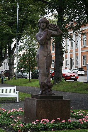
Liljan patsas
Distance: Approx. 70 meters
Latitude and longitude: 60.44861111,22.27166667
Lilja is a red granite sculpture by Wäinö Aaltonen, located in Turku, Finland. It is located in Runeberginpuisto near the Aurasilta. It depicts the lily, the flower of the Turku coat of arms.

Turku Market Hall
Market hall in Turku, Finland
Distance: Approx. 262 meters
Latitude and longitude: 60.44972222,22.26611111
Turku Market Hall is the second oldest market hall in Finland, and it was opened in 1896 in Turku.
Hamburger Börs, Turku
Distance: Approx. 286 meters
Latitude and longitude: 60.45111111,22.26861111
Hamburger Börs was an Art Nouveau hotel building in Turku, Finland, next to the Market Square built in 1909. It was designed by Frithiof Strandell as an expansion to a hotel located on Kauppiaskatu. The building had 30 hotel rooms.
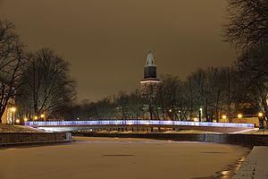
Library Bridge
A bridge in Turku, Finland.
Distance: Approx. 124 meters
Latitude and longitude: 60.44944444,22.27208333
The Library Bridge (Finnish: Kirjastosilta, Swedish: Biblioteksbron) is a pedestrian and cycling bridge in Turku designed by Pontek Oy. Located at the city centre, the bridge crosses the Aura River connecting the streets Kauppiaskatu and Rettiginrinne. The bridge was opened for traffic in 2013, and it was named as the result of a public naming contest.
Weather in this IP's area
clear sky
11 Celsius
11 Celsius
10 Celsius
11 Celsius
1031 hPa
100 %
1031 hPa
1030 hPa
10000 meters
1.54 m/s
250 degree
07:10:52
19:37:46