Country:
Region:
City:
Latitude and Longitude:
Time Zone:
Postal Code:
IP information under different IP Channel
ip-api
Country
Region
City
ASN
Time Zone
ISP
Blacklist
Proxy
Latitude
Longitude
Postal
Route
Luminati
Country
Region
19
City
turku
ASN
Time Zone
Europe/Helsinki
ISP
Elisa Oyj
Latitude
Longitude
Postal
IPinfo
Country
Region
City
ASN
Time Zone
ISP
Blacklist
Proxy
Latitude
Longitude
Postal
Route
db-ip
Country
Region
City
ASN
Time Zone
ISP
Blacklist
Proxy
Latitude
Longitude
Postal
Route
ipdata
Country
Region
City
ASN
Time Zone
ISP
Blacklist
Proxy
Latitude
Longitude
Postal
Route
Popular places and events near this IP address

Turku Student Village
Distance: Approx. 1145 meters
Latitude and longitude: 60.4625,22.29166667
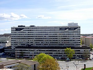
Turku Student Village (Finnish: Turun ylioppilaskylä, abbreviated Yo-kylä, Swedish: Studentbyn) is the largest single student housing complex in Finland. It houses nearly 3,500 residents in 95 three-storied tenements. The Student Village is located in the district of Nummi near the city centre of Turku.
Turku School of Economics
Distance: Approx. 1413 meters
Latitude and longitude: 60.45458333,22.28861111
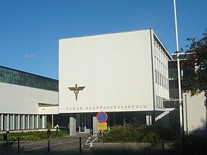
Turku School of Economics (Finnish Turun kauppakorkeakoulu) is a unit of the University of Turku located in Turku, Finland. It was established as an independent higher education business school in 1950, until it was acquired by the state in 1977. It was the second largest school of its kind in Finland, with approximately 2,000 graduate and 250 postgraduate students and a staff of 350.

Turku University Hospital
Hospital in Turku, Finland
Distance: Approx. 1387 meters
Latitude and longitude: 60.45333333,22.29055556
Turku University Hospital (Finnish: Turun yliopistollinen keskussairaala, TYKS, Swedish: Åbo universitetscentralsjukhus, ÅUCS) is a hospital in Turku, Finland.

Halinen
District of Turku, Finland
Distance: Approx. 1355 meters
Latitude and longitude: 60.47194444,22.31666667
Halinen (Finnish; Hallis in Swedish) is a district and a suburb of the city of Turku, Finland. It is located in the north-eastern part of the city, bordering the Littoinen district in Kaarina. It is rather densely populated, having a population of 3,501 (as of 2004), with an annual growth rate of 0.34%.

Nummi, Turku
Distance: Approx. 270 meters
Latitude and longitude: 60.45833333,22.30833333
Nummi (Finnish; Nummisbacken in Swedish) is a district and a suburb of the city of Turku, Finland. It is located in the north-eastern part of the city, just outside the city centre and south of the river Aura. It is the fourth largest district in Turku, having a population of 7,011 (as of 2004), with an annual growth rate of 2.21%.
Posankka
Statue located in Turku, Finland
Distance: Approx. 1235 meters
Latitude and longitude: 60.45858333,22.28958333
Posankka (Swedish: Grisankan) is a statue located in Turku, Finland. The statue, which is located near the campus area of the University of Turku and the Turku Student Village, represents a hybrid between a marzipan pig ("possu") and a rubber duck ("ankka"). It is a pink animal with a duck's lower body and a pig's head.

Itäharju
District of Turku, Finland
Distance: Approx. 1130 meters
Latitude and longitude: 60.45,22.30833333
Itäharju (Swedish: Österås) is a district in the Itäharju-Varissuo ward of the city of Turku, in Finland. It is located to the east of the city centre, and consists mostly of industrial area, brownfields and low-density residential area. Since the beginning of the 2000s the trend of renovating old industrial buildings to offices has sprawled over from the neighboring Kupittaa to Itäharju as well.

Kurala
Distance: Approx. 880 meters
Latitude and longitude: 60.46111111,22.32777778
Kurala is a district in the Itäharju-Varissuo ward of the city of Turku, in Finland. It is located to the northeast of the city, and is largely a low-density residential suburb. The current (as of 2004) population of Kurala is 2,956, and it is decreasing at an annual rate of 1.25%.

Koroinen
District of Turku, Finland
Distance: Approx. 1404 meters
Latitude and longitude: 60.466019,22.289414
Koroinen (Finnish: [ˈkoroi̯nen]; Korois in Swedish) is a district in the Koroinen ward of the city of Turku, in Finland. It is located to the north of the city centre, across the river Aura from the Turku Student Village. Koroinen is mostly non-built-up area, consisting largely of recreational area.

Kupittaa railway station
Railway station in Turku, Finland
Distance: Approx. 1334 meters
Latitude and longitude: 60.45055556,22.29694444
Kupittaa railway station (Finnish: Kupittaan rautatieasema, Swedish: Kuppis järnvägsstation) is located in the Kupittaa district of Turku, Finland. The station is located about three kilometres from the Turku Central railway station in the immediate vicinity of the Turku Science Park. All trains between Helsinki and Turku stop at Kupittaa.

St. Catherine's Church, Turku
Church in Turku, Finland
Distance: Approx. 1034 meters
Latitude and longitude: 60.46222222,22.29361111
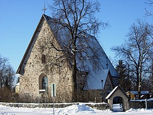
St. Catherine's Church (Finnish: Pyhän Katariinan kirkko, Swedish: S:ta Katarina kyrka) is located in Nummi, a suburb of Turku, Finland, in the same district as Turku Student Village. It represents the old medieval stone church building tradition.

Virnamäki
Archaeological site in Turku, Finland
Distance: Approx. 797 meters
Latitude and longitude: 60.46628508,22.31885658
Virnamäki (Finnish 'vetch hill') is a hill and glade ancient monument area from the Iron Age in Turku, Finland. In addition to having been a dwelling site, the area is also known for its cremation cemeteries under level ground and also multiple stones with cup marks. The area is protected under the Finnish Antiquities Act (Muinaismuistolaiki).
Weather in this IP's area
overcast clouds
5 Celsius
5 Celsius
5 Celsius
6 Celsius
1032 hPa
99 %
1032 hPa
1028 hPa
10000 meters
1.03 m/s
100 %
08:16:37
16:12:40
