Country:
Region:
City:
Latitude and Longitude:
Time Zone:
Postal Code:
IP information under different IP Channel
ip-api
Country
Region
City
ASN
Time Zone
ISP
Blacklist
Proxy
Latitude
Longitude
Postal
Route
Luminati
Country
ASN
Time Zone
Europe/Berlin
ISP
PHOENIX Pharmahandel GmbH & Co KG
Latitude
Longitude
Postal
IPinfo
Country
Region
City
ASN
Time Zone
ISP
Blacklist
Proxy
Latitude
Longitude
Postal
Route
db-ip
Country
Region
City
ASN
Time Zone
ISP
Blacklist
Proxy
Latitude
Longitude
Postal
Route
ipdata
Country
Region
City
ASN
Time Zone
ISP
Blacklist
Proxy
Latitude
Longitude
Postal
Route
Popular places and events near this IP address

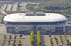
SAP Arena
Multi-purpose arena in Mannheim, Baden-Württemberg, Germany
Distance: Approx. 1605 meters
Latitude and longitude: 49.46413889,8.51797222
SAP Arena is a multi-purpose arena in Mannheim, Germany. It is primarily used for ice hockey and handball, and is the home arena of the Adler Mannheim ice hockey club and the Rhein-Neckar Löwen handball club. Inaugurated in 2005, the arena has a capacity of up to 15,000 people.

Rhine-Neckar
Place in Germany
Distance: Approx. 2291 meters
Latitude and longitude: 49.4438,8.4756
The Rhine-Neckar Metropolitan Region (German: Metropolregion Rhein-Neckar, pronounced [metʁoˈpoːlʁeˌɡi̯oːn ˌʁaɪnˈnɛkaʁ]), often referred to as Rhein-Neckar-Triangle, is a polycentric metropolitan region located in south western Germany, between the Frankfurt/Rhine-Main region to the North and the Stuttgart Region to the South-East. Rhine-Neckar has a population of some 2.4 million with major cities being Mannheim, Ludwigshafen and Heidelberg. Other cities include the former Free imperial cities of Speyer and Worms.
Carl-Benz-Stadion
Stadium in Mannheim, Germany
Distance: Approx. 2338 meters
Latitude and longitude: 49.47944444,8.5025
Carl-Benz-Stadion is a multi-purpose stadium in Mannheim, Germany. It is currently used mostly for football matches and is the home stadium of SV Waldhof Mannheim. In 2008, it also hosted TSG 1899 Hoffenheim for the first half of that club's first season in the Bundesliga, until Hoffenheim's new stadium opened in January 2009.

Mannheim City Airport
Minor regional airport in Mannheim, Baden-Württemberg, Germany
Distance: Approx. 1956 meters
Latitude and longitude: 49.4725,8.51416667
Mannheim City Airport (IATA: MHG, ICAO: EDFM) (City-Airport Mannheim in German, formerly Mannheim-Neuostheim/Neuhermsheim) is a minor regional airport serving the German city of Mannheim. It is mainly used for general aviation.
Neuostheim/Neuhermsheim
Suburb of Mannheim, Germany
Distance: Approx. 1167 meters
Latitude and longitude: 49.466,8.509
Neuostheim/Neuhermsheim is a suburb of the city of Mannheim, Germany, composed of Neuostheim and Neuhermsheim and is considered to be one of the more attractive neighbourhoods of Mannheim. It is located 3.5 km (2.2 mi) east of the city centre. It lies on the River Neckar and an important lock on the Neckar Canal is situated between Neuostheim and the suburb of Feudenheim.
Mannheim University of Applied Sciences
Public higher education institute in Germany
Distance: Approx. 1635 meters
Latitude and longitude: 49.46955556,8.48220833
The Mannheim University of Applied Sciences is a public higher education institute located in Mannheim, Germany. Referred to as Technische Hochschule Mannheim in German and previously known as Fachhochschule Mannheim, it offers degree programs at bachelor's and master's level in the fields of engineering, informatics, biotechnology, design, and social affairs.

Mannheim May Market
Largest regional consumer exhibition of Germany
Distance: Approx. 2345 meters
Latitude and longitude: 49.46916667,8.52555556
The May Market (German: Maimarkt) is the largest regional consumer exhibition of Germany, which always begins on last Saturday in April and lasts for eleven days. The traditionally last day is therefore called May Market Tuesday. It takes place at the Maimarktgelände in Mannheim, Baden-Württemberg.

Technoseum
Technology museum in Mannheim, Germany
Distance: Approx. 1970 meters
Latitude and longitude: 49.476396,8.49755
The Technoseum (former name State Museum of Technology and Work, German: Landesmuseum für Technik und Arbeit) is a technology museum in Mannheim, Baden-Württemberg, Germany, with displays covering the industrialisation of the south-western regions of the country. The museum building was designed by the Berlin architect Ingeborg Kühler. Its planning and construction period lasted from 1982 to 1990.

Maimarktgelände
Exhibition site in Mannheim, Germany
Distance: Approx. 2345 meters
Latitude and longitude: 49.46916667,8.52555556
The Maimarktgelände (May Market Grounds) is an exhibition site located in Mannheim, Germany, which covers a surface of 210,000 m2. It hosts the annual Mannheim May Market as well as open-air concerts and other events. Starting in April each year, 47 exhibition halls with a surface of 42,000 m2 are developed on the apron of the site.

Ehsaan Mosque, Mannheim
Mosque in Mannheim, Baden-Württemberg, Germany
Distance: Approx. 1243 meters
Latitude and longitude: 49.448911,8.505697
Ehsan Mosque (German: Ehsan Moschee) is an Ahmadi Muslim mosque in Mannheim, in the German state of Baden-Württemberg.

Mannheim ARENA/Maimarkt station
Railway station
Distance: Approx. 1344 meters
Latitude and longitude: 49.46,8.5159
Mannheim ARENA/Maimarkt station (German: Haltepunkt Mannheim ARENA/Maimarkt) is a railway station in the municipality of Mannheim, located in Baden-Württemberg, Germany.

Mannheim Rangierbahnhof
Germany's second-largest marshalling yard
Distance: Approx. 1783 meters
Latitude and longitude: 49.45583333,8.52166667
The Mannheim Rangierbahnhof (German for Mannheim marshalling yard) is a marshalling yard in Mannheim, Baden-Württemberg, Germany. It is the second-largest marshalling yard in Germany after the Maschen Marshalling Yard.
Weather in this IP's area
clear sky
7 Celsius
4 Celsius
5 Celsius
7 Celsius
1015 hPa
85 %
1015 hPa
1003 hPa
10000 meters
4.12 m/s
240 degree
07:40:42
16:41:39

