193.141.71.50 - IP Lookup: Free IP Address Lookup, Postal Code Lookup, IP Location Lookup, IP ASN, Public IP
Country:
Region:
City:
Location:
Time Zone:
Postal Code:
IP information under different IP Channel
ip-api
Country
Region
City
ASN
Time Zone
ISP
Blacklist
Proxy
Latitude
Longitude
Postal
Route
Luminati
Country
ASN
Time Zone
Europe/Amsterdam
ISP
KPN B.V.
Latitude
Longitude
Postal
IPinfo
Country
Region
City
ASN
Time Zone
ISP
Blacklist
Proxy
Latitude
Longitude
Postal
Route
IP2Location
193.141.71.50Country
Region
groningen
City
uithuizen
Time Zone
Europe/Amsterdam
ISP
Language
User-Agent
Latitude
Longitude
Postal
db-ip
Country
Region
City
ASN
Time Zone
ISP
Blacklist
Proxy
Latitude
Longitude
Postal
Route
ipdata
Country
Region
City
ASN
Time Zone
ISP
Blacklist
Proxy
Latitude
Longitude
Postal
Route
Popular places and events near this IP address

Eemsmond
Former municipality in Groningen, Netherlands
Distance: Approx. 879 meters
Latitude and longitude: 53.4,6.66666667
Eemsmond (Dutch pronunciation: [ˈeːmsmɔnt] ; English: Ems Mouth) is a former municipality with a population of 15,864 in the north of the province of Groningen in the northeast of the Netherlands. On 1 January 2019 it merged with the municipalities of Bedum, De Marne and Winsum to form the new municipality Het Hogeland.

Usquert
Village in Groningen, Netherlands
Distance: Approx. 3688 meters
Latitude and longitude: 53.4,6.61666667
Usquert is a village in the Dutch province of Groningen. It is located in the municipality of Het Hogeland. It had a population of around 1,415 in January 2017.

Eppenhuizen
Hamlet in Groningen, Netherlands
Distance: Approx. 3316 meters
Latitude and longitude: 53.38333333,6.7
Eppenhuizen is a hamlet in the Dutch province of Groningen. It had a population of around 50 in January 2017.

Menkemaborg
Historic house museum in Uithuizen, Netherlands
Distance: Approx. 912 meters
Latitude and longitude: 53.405,6.68388889
The Menkemaborg (Dutch pronunciation: [ˈmɛŋkəmaːˌbɔr(ə)x]; Menkema Borough) is a borg (castle) in the village of Uithuizen in Groningen in the Netherlands. Since 1927, the borg is a historic house museum.
Hefshuizen
Distance: Approx. 2154 meters
Latitude and longitude: 53.415364,6.700459
Hefshuizen is a former municipality in the Dutch province of Groningen. Hefshuizen was created in 1979, in the merger of the former municipalities of Uithuizen and Uithuizermeeden. In 1990, Kantens, Usquert, and Warffum were added, and in 1992, the name of the municipality was changed to Eemsmond.

Uithuizermeeden railway station
Railway station in the Netherlands
Distance: Approx. 3389 meters
Latitude and longitude: 53.41361111,6.72083333
Uithuizermeeden is a railway station located in Uithuizermeeden, The Netherlands. The station was opened on 16 August 1893 and is located on the Sauwerd–Roodeschool railway. The services are operated by Arriva.

Uithuizen railway station
Railway station in the Netherlands
Distance: Approx. 325 meters
Latitude and longitude: 53.40944444,6.67444444
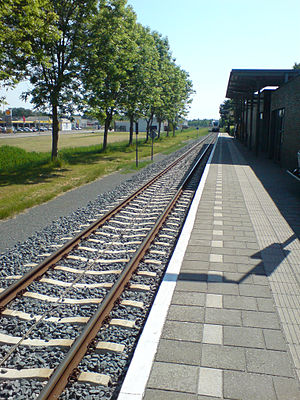
Uithuizen (abbreviation: Uhz) is a railway station located in Uithuizen in the Netherlands. The station was opened on 16 August 1893 and is located on the Sauwerd–Roodeschool railway. The train services are operated by Arriva.

Rensumaborg
Borg in Uithuizermeeden, Netherlands
Distance: Approx. 2979 meters
Latitude and longitude: 53.415,6.71388889
The Rensumaborg is a borg in the village of Uithuizermeeden in Groningen in the Netherlands.

Organ in the Jacobikerk at Uithuizen
Distance: Approx. 187 meters
Latitude and longitude: 53.40736111,6.67361111
The Jacobikerk organ in Uithuizen in the Dutch province of Groningen was built in 1701 by Arp Schnitger. It has 28 stops which are distributed on two manuals and pedal. The instrument is one of the best preserved Schnitger organs.

Het Hogeland
Municipality in Groningen, Netherlands
Distance: Approx. 803 meters
Latitude and longitude: 53.41361111,6.67722222
Het Hogeland is a municipality in the north of the province of Groningen in the northeast of the Netherlands.

Doodstil
Hamlet in Groningen, Netherlands
Distance: Approx. 1886 meters
Latitude and longitude: 53.39062,6.67326
Doodstil is a hamlet in the Dutch province of Groningen. It is a part of the municipality of Het Hogeland. The hamlet is known for its name which seemingly translates to "dead silent".

Boterdiep
Canal in Groningen
Distance: Approx. 422 meters
Latitude and longitude: 53.40592,6.67658
Boterdiep (Gronings: Botterdaip; translation: Butter Deep) is a canal in the Province of Groningen in the Netherlands. It was intended for the inland navigation. The name relates to the dairy products transported through the canal.
Weather in this IP's area
overcast clouds
7 Celsius
4 Celsius
7 Celsius
7 Celsius
1028 hPa
95 %
1028 hPa
1028 hPa
10000 meters
4.34 m/s
7.27 m/s
213 degree
100 %