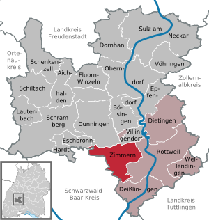
Country:
Region:
City:
Latitude and Longitude:
Time Zone:
Postal Code:
IP information under different IP Channel
ip-api
Country
Region
City
ASN
Time Zone
ISP
Blacklist
Proxy
Latitude
Longitude
Postal
Route
Luminati
Country
Region
bw
City
rottweil
ASN
Time Zone
Europe/Berlin
ISP
Vodafone GmbH
Latitude
Longitude
Postal
IPinfo
Country
Region
City
ASN
Time Zone
ISP
Blacklist
Proxy
Latitude
Longitude
Postal
Route
db-ip
Country
Region
City
ASN
Time Zone
ISP
Blacklist
Proxy
Latitude
Longitude
Postal
Route
ipdata
Country
Region
City
ASN
Time Zone
ISP
Blacklist
Proxy
Latitude
Longitude
Postal
Route
Popular places and events near this IP address
Rottweil (district)
District in Baden-Württemberg, Germany
Distance: Approx. 268 meters
Latitude and longitude: 48.17,8.63
Rottweil is a Landkreis (district) in the middle of Baden-Württemberg, Germany. It is part of the Schwarzwald-Baar-Heuberg region in the Breisgau-Hochschwarzwald regional district. Neighboring districts are (from north clockwise) Freudenstadt, Zollernalbkreis, Tuttlingen, Schwarzwald-Baar and Ortenaukreis.

Rottweil
Town in Baden-Württemberg, Germany
Distance: Approx. 380 meters
Latitude and longitude: 48.16805556,8.62472222
Rottweil (German: [ˈʁɔtvaɪl] ; Alemannic: Rautweil) is a town in southwest Germany in the state of Baden-Württemberg. Rottweil was a free imperial city for nearly 600 years. Located between the Black Forest and the Swabian Alps, Rottweil has over 25,000 inhabitants as of 2022.

Dietingen
Municipality in Baden-Württemberg, Germany
Distance: Approx. 4395 meters
Latitude and longitude: 48.20555556,8.64611111
Dietingen is a municipality in the district of Rottweil, in Baden-Württemberg, Germany.

Villingendorf
Municipality in Baden-Württemberg, Germany
Distance: Approx. 4882 meters
Latitude and longitude: 48.20194444,8.58888889
Villingendorf (Swabian: Villingedorf) is a town in the district of Rottweil, in Baden-Württemberg, Germany.

Zimmern ob Rottweil
Municipality in Baden-Württemberg, Germany
Distance: Approx. 2873 meters
Latitude and longitude: 48.16805556,8.59111111
Zimmern ob Rottweil is a town in the district of Rottweil, in Baden-Württemberg, Germany. The municipality includes the former independent municipalities Zimmern ob Rottweil, Flözlingen, Horgen and Stetten ob Rottweil. Zimmern is located on a plateau over the upper Neckar valley, the villages Horgen, Stetten and Flözlingen are located in the Eschach valley.

Zollernbahn Railway Society
German railway society for historic trains
Distance: Approx. 901 meters
Latitude and longitude: 48.16583,8.64164
The Eisenbahnfreunde Zollernbahn (EFZ) (Zollernbahn Railway Society) is a German railway society dedicated to the preservation of historic railway vehicles, especially steam locomotives, where possible in working order. The society arranges day and shuttle trips, predominantly in Baden-Württemberg in southwestern Germany. It is based at Rottweil.

Eschach (Neckar)
River in Germany
Distance: Approx. 3087 meters
Latitude and longitude: 48.1399,8.6279
The Eschach (upstream from Horgen also: Württembergische Eschach) is a river of Baden-Württemberg, Germany. It flows into the Neckar south of Rottweil.

Prim (Neckar)
River in Germany
Distance: Approx. 1247 meters
Latitude and longitude: 48.1652,8.6462
Prim is a river of Baden-Württemberg, Germany. It is a right tributary of the Neckar in Rottweil.

Rottweil station
Start of the Rottweil–Villingen railway
Distance: Approx. 937 meters
Latitude and longitude: 48.16472222,8.64166667
Rottweil station is on the Plochingen–Immendingen railway in the German state of Baden-Württemberg and is the start of the Rottweil–Villingen railway. It lies on the northeastern edge of Rottweil at a height of 557 metres above sea level.
Rottenmünster Abbey
Distance: Approx. 1906 meters
Latitude and longitude: 48.15083333,8.635
Rottenmünster Abbey, also the Imperial Nunnery of Rottenmünster (German: Kloster Rottenmünster), was a Cistercian abbey located near Rottweil in Baden-Württemberg. The self-ruling Imperial Abbey was secularized in the course of the German mediatization of 1802–1803 and its territory annexed to the Duchy of Württemberg. The monastery was closed in 1850.

Rottweil Synagogue
Former synagogue in Rottweil, Baden-Württemberg, Germany
Distance: Approx. 103 meters
Latitude and longitude: 48.1669,8.6289
The Rottweil Synagogue was a former Jewish congregation and synagogue, located in Rottweil, in the state of Baden-Württemberg, Germany. Completed in 1861, the synagogue was destroyed by Nazis during Kristallnacht, on November 9, 1938. The desecrated synagogue is located in Kameralamtsgasse 6, former Judengasse, close to Kapellenkirche and next to Bischöfliches Konvikt and gymnasium.

TK Elevator Test Tower
Elevator test tower in Rottweil, Germany
Distance: Approx. 1327 meters
Latitude and longitude: 48.179119,8.62518
The TK Elevator Test Tower (TK-Elevator-Testturm) is an elevator test tower in Rottweil, Germany. It is owned by TK Elevator, who have their elevator research campus nearby. It stands 246 m (807 ft) tall and was built to test the company's MULTI elevator system.
Weather in this IP's area
scattered clouds
4 Celsius
2 Celsius
3 Celsius
5 Celsius
1026 hPa
100 %
1026 hPa
955 hPa
10000 meters
1.78 m/s
1.71 m/s
187 degree
38 %
07:17:21
17:00:48