Country:
 Netherlands
Region:
City:
Latitude and Longitude:
Time Zone:
Postal Code:
IP information under different IP Channel
ip-api
Country
Region
City
ASN
Time Zone
ISP
Blacklist
Proxy
Latitude
Longitude
Postal
Route
IPinfo
Country
Region
City
ASN
Time Zone
ISP
Blacklist
Proxy
Latitude
Longitude
Postal
Route
MaxMind
Country
Region
City
ASN
Time Zone
ISP
Blacklist
Proxy
Latitude
Longitude
Postal
Route
Luminati
Country
NLASN
Time Zone
Europe/Amsterdam
ISP
KPN B.V.
Latitude
Longitude
Postal
db-ip
Country
Region
City
ASN
Time Zone
ISP
Blacklist
Proxy
Latitude
Longitude
Postal
Route
ipdata
Country
Region
City
ASN
Time Zone
ISP
Blacklist
Proxy
Latitude
Longitude
Postal
Route
Popular places and events near this IP address

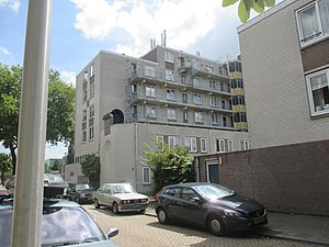
Oog in Al
Residential area
Distance: Approx. 904 meters
Latitude and longitude: 52.0859092,5.0865412
Oog in Al (Dutch pronunciation: [ˌoːx ɪn ˈɑl], Utrecht dialect: [ˌouχ ɪn ˈæl]) is a residential area in the west of the city of Utrecht in the Netherlands. The Amsterdam–Rhine Canal, the Merwede Canal and the Leidse Rijn canal form the area's limits, rendering it a man-made island in the shape of a triangle. From the 12th century, the area of present-day Oog in Al was part of the 'Trechter Weide', the communal meadow of the city of Utrecht.

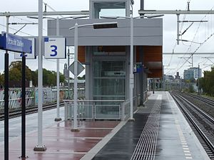
Utrecht Centraal railway station
Railway station in the Netherlands
Distance: Approx. 1354 meters
Latitude and longitude: 52.08916667,5.10972222
Utrecht Centraal, officially Station Utrecht Centraal (Dutch: [staːˈʃɔn ˈytrɛxt sɛnˈtraːl]), is the transit hub that integrates three bicycle parkings, two bus stations, two tram stops and the central railway station for Utrecht, Netherlands. It is the biggest train station in the Netherlands. Both the railway station and the bus station are the largest and busiest in the Netherlands.
Catharijne
Distance: Approx. 1460 meters
Latitude and longitude: 52.08972222,5.11166667
Catharijne is a former municipality on the west side of the Dutch city of Utrecht. It was a separate municipality between 1818 and 1823, when it merged with the city of Utrecht. It was named for the St.
Ondiep
Working-class district
Distance: Approx. 940 meters
Latitude and longitude: 52.1,5.1
Ondiep is a working-class district in northwest Utrecht, Netherlands, between the river Vecht and Amsterdamsestraatweg street. Ondiep was constructed starting 1915. From the 1930, the district was used to house "abnormals", under the supervision of police, social work and medical workers.
Utrecht Zuilen railway station
Railway station in the Netherlands
Distance: Approx. 1073 meters
Latitude and longitude: 52.10305556,5.08916667
Utrecht Zuilen is a railway station located in Utrecht, Netherlands. The station opened on 10 June 2007 and is located on the Amsterdam–Arnhem railway. The services are currently operated by Nederlandse Spoorwegen.
Hollandia Roeiclub
Distance: Approx. 1153 meters
Latitude and longitude: 52.085101,5.081345
Hollandia Roeiclub (HRC) is a Dutch rowing club based in Utrecht open to current members and former members of the Dutch national rowing team.

Jaarbeurs
Exhibition and convention center in Utrecht, Netherlands
Distance: Approx. 1336 meters
Latitude and longitude: 52.085,5.105
The Jaarbeurs (pronounced [ˈjaːrbøːrs]; Dutch for 'Yearly Fair') is an exhibition and convention centre in Utrecht, the Netherlands. Noted events include the former Space '86, the Hobby Computer Club Days (HCC Dagen), and the Mega Record & CD Fair. The venue used to be also a regular base for music festivals like ASOT festival and Thunderdome.

Rabobank Bestuurscentrum
Skyscraper in Utrecht, Netherlands
Distance: Approx. 1396 meters
Latitude and longitude: 52.08694444,5.10861111
The Rabobank Bestuurscentrum or Rabotoren (English: Rabobank Executive Centre or Rabotower) is a skyscraper in the Dutch city of Utrecht, built between 2007 and 2011 and designed by the architectural firm Kraaijvanger Urbis. At 105 metres (344 ft), it is the highest office building in the city, and the second highest building overall after the Dom Tower.
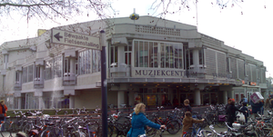
Muziekcentrum Vredenburg
Distance: Approx. 1519 meters
Latitude and longitude: 52.09222222,5.11333333
Muziekcentrum Vredenburg was a music venue in Utrecht, Netherlands with a capacity of 5,000 people. It was designed by Dutch architect Herman Hertzberger. The venue hosted concerts by many famous artists, spanning many different genres.
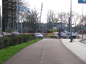
Utrecht tram shooting
Shooting on a tram in Utrecht, Netherlands
Distance: Approx. 1425 meters
Latitude and longitude: 52.0807,5.0914
On the morning of 18 March 2019, four people were killed and six others were injured in a mass shooting on a tram in Utrecht, Netherlands. One of the injured died of his injuries ten days later. Gökmen Tanis, a 37-year-old Turkish man, was arrested later that day following a major security operation and manhunt.

Amsterdamsestraatweg Water Tower
Water tower in Utrecht, the Netherlands
Distance: Approx. 1089 meters
Latitude and longitude: 52.103,5.095
The Amsterdamsestraatweg Water Tower is located in Utrecht, the Netherlands. The water tower was built at Amsterdamsestraatweg 380 in 1916, in the style of the Amsterdam School. It became derelict in 1986 and was repeatedly squatted before its redevelopment into apartments began in 2020.
Academie Tien
School
Distance: Approx. 1382 meters
Latitude and longitude: 52.0956,5.0713
Academie Tien (stylized as ACADEMİE TİEN) is a Dutch secondary school located in the city of Utrecht. The school officially opened in 2015 as Mavo Tien, which only offered education to students in the MAVO level. On August 1, 2018, the school changed its name to Academie Tien and started enrolling students in the HAVO and VWO levels.
Weather in this IP's area
clear sky
19 Celsius
19 Celsius
18 Celsius
19 Celsius
1009 hPa
86 %
1009 hPa
1009 hPa
10000 meters
0.45 m/s
0.45 m/s
104 degree
4 %
07:03:19
20:11:29