193.141.33.252 - IP Lookup: Free IP Address Lookup, Postal Code Lookup, IP Location Lookup, IP ASN, Public IP
Country:
 Netherlands
Region:
City:
Location:
Time Zone:
Postal Code:
ISP:
ASN:
language:
User-Agent:
Proxy IP:
Blacklist:
IP information under different IP Channel
ip-api
Country
Region
City
ASN
Time Zone
ISP
Blacklist
Proxy
Latitude
Longitude
Postal
Route
db-ip
Country
Region
City
ASN
Time Zone
ISP
Blacklist
Proxy
Latitude
Longitude
Postal
Route
IPinfo
Country
Region
City
ASN
Time Zone
ISP
Blacklist
Proxy
Latitude
Longitude
Postal
Route
IP2Location
193.141.33.252Country
nlRegion
noord-holland
City
den helder
Time Zone
Europe/Amsterdam
ISP
Language
User-Agent
Latitude
Longitude
Postal
ipdata
Country
Region
City
ASN
Time Zone
ISP
Blacklist
Proxy
Latitude
Longitude
Postal
Route
Popular places and events near this IP address

HNLMS Abraham Crijnssen (1936)
Dutch minesweeper
Distance: Approx. 892 meters
Latitude and longitude: 52.96388889,4.77083333
HNLMS Abraham Crijnssen is a Jan van Amstel-class minesweeper of the Royal Netherlands Navy (RNN). Built during the 1930s, she was based in the Dutch East Indies when Japan attacked at the end of 1941. Ordered to retreat to Australia, the ship was disguised as a tropical island to avoid detection, and was the last Dutch ship to escape from the region.

HNLMS Schorpioen
19th century Royal Netherlands Navy ship
Distance: Approx. 900 meters
Latitude and longitude: 52.96242,4.77206
HNLMS Schorpioen is a Schorpioen-class monitor built in France for the Royal Netherlands Navy in the 1860s. These new ships were equipped with heavy rifled 23 cm (9 in) guns, and a heavy armor. The hull had an armor plated belt of 15 cm (6 in) and the gun turret, housing the two guns, had almost 30 cm (12 in) of armor.
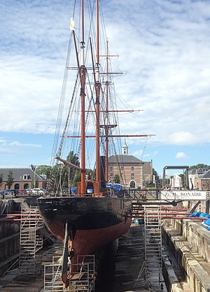
HNLMS Bonaire
Distance: Approx. 732 meters
Latitude and longitude: 52.961079,4.770046
HNLMS Bonaire is a Samarang-class gunvessel of the Royal Netherlands Navy, now under restoration as a museum ship.

Dutch Navy Museum
Naval museum in Den Helder, Netherlands
Distance: Approx. 938 meters
Latitude and longitude: 52.9638,4.7717
The Dutch Navy Museum is a naval museum in Den Helder, Netherlands. The museum is dedicated to the history of the Koninklijke Marine (Royal Netherlands Navy).

Royal Naval College (Netherlands)
Distance: Approx. 1084 meters
Latitude and longitude: 52.96222222,4.775
The Royal Naval College was the service academy of the Royal Netherlands Navy. From 2005 it is part of the Koninklijk Instituut voor de Marine ("Royal naval institute" or KIM) as part of the Nederlandse Defensie Academie ("Netherlands defence academy") in Den Helder. It offers a program of four or five years and also a short course of 16 to 22 months.

Den Helder railway station
Railway station in the Netherlands
Distance: Approx. 404 meters
Latitude and longitude: 52.95638889,4.76083333
Den Helder is a Terminus railway station in the naval town of Den Helder, The Netherlands. The station opened on 20 December 1865, and is the most northerly station in North Holland. The station is the start of the Den Helder–Amsterdam railway.

Willemsoord, Den Helder
Maritime museum in the Netherlands
Distance: Approx. 848 meters
Latitude and longitude: 52.9609,4.77184
Willemsoord is a large former naval base of the Royal Netherlands Navy in Den Helder. It is now connected to the city center of Den Helder, and focuses on entertainment and tourism.

Capture of the Dutch fleet at Den Helder
1795 battle in the War of the First Coalition
Distance: Approx. 180 meters
Latitude and longitude: 52.9583,4.7589
The Capture of the Dutch fleet at Den Helder on the night of 23 January 1795 presents a rare occurrence of an interaction between warships and cavalry, in which a French Revolutionary Hussar regiment came close to a Dutch fleet frozen at anchor in the Nieuwediep, just east of the town of Den Helder. After some of the Hussars had approached across the frozen Nieuwediep, the French cavalry negotiated that all 14 Dutch warships would remain at anchor. A capture of ships by horsemen is an extremely rare feat in military history.

HNLMS Tonijn (S805)
Distance: Approx. 910 meters
Latitude and longitude: 52.96376714,4.77125554
HNLMS Tonijn (Dutch: Thunnus) was a Potvis-class submarine (modified Dolfijn class) of the Royal Netherlands Navy.

Nieuwe Haven Naval Base
Dutch navy installation in Den Helder, North Holland, Netherlands
Distance: Approx. 2073 meters
Latitude and longitude: 52.956,4.78952778
Nieuwe Haven is a Royal Netherlands Navy base in Den Helder and the largest naval base in the Netherlands.

Fort Harssens
Fortress in Den Helder, Netherlands
Distance: Approx. 1559 meters
Latitude and longitude: 52.964002,4.78153
Fort Harssens is a former fortress and museum in Den Helder North-Holland. It protected the naval base Willemsoord. The fortress had 4 heavy naval guns placed in two armored cupolas.

Fortifications of Den Helder
Distance: Approx. 193 meters
Latitude and longitude: 52.958353,4.757987
The Fortifications of Den Helder form a circle of fortresses and other works that defended Den Helder in the Netherlands from the end of the 18th century till the end of World War II. They are now getting repurposed for tourism.
Weather in this IP's area
heavy intensity rain
2 Celsius
-4 Celsius
2 Celsius
2 Celsius
1025 hPa
80 %
1025 hPa
1025 hPa
10000 meters
9.77 m/s
80 degree
100 %