193.138.155.123 - IP Lookup: Free IP Address Lookup, Postal Code Lookup, IP Location Lookup, IP ASN, Public IP
Country:
 Czech Republic
Region:
City:
Location:
Time Zone:
Postal Code:
ISP:
ASN:
language:
User-Agent:
Proxy IP:
Blacklist:
IP information under different IP Channel
ip-api
Country
Region
City
ASN
Time Zone
ISP
Blacklist
Proxy
Latitude
Longitude
Postal
Route
db-ip
Country
Region
City
ASN
Time Zone
ISP
Blacklist
Proxy
Latitude
Longitude
Postal
Route
IPinfo
Country
Region
City
ASN
Time Zone
ISP
Blacklist
Proxy
Latitude
Longitude
Postal
Route
IP2Location
193.138.155.123Country
czRegion
kralovehradecky kraj
City
nachod
Time Zone
Europe/Prague
ISP
Language
User-Agent
Latitude
Longitude
Postal
ipdata
Country
Region
City
ASN
Time Zone
ISP
Blacklist
Proxy
Latitude
Longitude
Postal
Route
Popular places and events near this IP address

Náchod
Town in Hradec Králové, Czech Republic
Distance: Approx. 29 meters
Latitude and longitude: 50.41694444,16.16305556
Náchod (Czech pronunciation: [ˈnaːxot]; German: Nachod) is a town in the Hradec Králové Region of the Czech Republic. It has about 20,000 inhabitants. It is known both as a tourist destination and centre of industry.
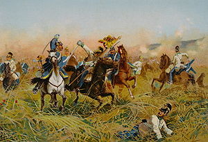
Battle of Náchod
Battle during the Austro-Prussian War
Distance: Approx. 2470 meters
Latitude and longitude: 50.42611111,16.19444444
The Battle of Náchod (German: Nachod) on 27 June 1866 was the first major action of the Austro-Prussian War. The advance guard of General Karl Friedrich von Steinmetz's 5th Corps occupied some high ground near Náchod as part of a Prussian advance into Bohemia from Silesia. Elements of the Austrian 6th Corps under General Von Ramming came on the scene and attacked the Prussians but were repulsed.

Česká Čermná
Municipality in Hradec Králové, Czech Republic
Distance: Approx. 5041 meters
Latitude and longitude: 50.40083333,16.22944444
Česká Čermná is a municipality and village in Náchod District in the Hradec Králové Region of the Czech Republic. It has about 500 inhabitants.

Dolní Radechová
Municipality in Hradec Králové, Czech Republic
Distance: Approx. 2543 meters
Latitude and longitude: 50.43833333,16.15138889
Dolní Radechová (German: Nieder Radechau) is a municipality and village in Náchod District in the Hradec Králové Region of the Czech Republic. It has about 800 inhabitants.

Kramolna
Municipality in Hradec Králové, Czech Republic
Distance: Approx. 2032 meters
Latitude and longitude: 50.42083333,16.135
Kramolna is a municipality and village in Náchod District in the Hradec Králové Region of the Czech Republic. It has about 1,100 inhabitants.

Provodov-Šonov
Municipality in Hradec Králové, Czech Republic
Distance: Approx. 5090 meters
Latitude and longitude: 50.38722222,16.10805556
Provodov-Šonov is a municipality in Náchod District in the Hradec Králové Region of the Czech Republic. It has about 1,200 inhabitants. Part of Rozkoš Reservoir lies in the municipality.

Přibyslav (Náchod District)
Municipality in Hradec Králové, Czech Republic
Distance: Approx. 4814 meters
Latitude and longitude: 50.37361111,16.16861111
Přibyslav (German: Prenzlau) is a municipality and village in Náchod District in the Hradec Králové Region of the Czech Republic. It has about 200 inhabitants.

Studnice (Náchod District)
Municipality in Hradec Králové, Czech Republic
Distance: Approx. 5197 meters
Latitude and longitude: 50.42138889,16.09
Studnice is a municipality and village in Náchod District in the Hradec Králové Region of the Czech Republic. It has about 1,200 inhabitants.

Velké Poříčí
Market town in Hradec Králové, Czech Republic
Distance: Approx. 5348 meters
Latitude and longitude: 50.46166667,16.18944444
Velké Poříčí (German: Groß Poritsch) is a market town in Náchod District in the Hradec Králové Region of the Czech Republic. It has about 2,400 inhabitants.

Vysokov
Municipality in Hradec Králové, Czech Republic
Distance: Approx. 3577 meters
Latitude and longitude: 50.40388889,16.11666667
Vysokov (German: Hohenfeld) is a municipality and village in Náchod District in the Hradec Králové Region of the Czech Republic. It has about 500 inhabitants.

Klikawa (stream)
River in Poland, Czech Republic
Distance: Approx. 2837 meters
Latitude and longitude: 50.43166667,16.19527778
The Klikawa (Czech: Střela) is a stream in Poland and the Czech Republic, a tributary of the Metuje near Náchod. It flows through Lewin Kłodzki and Kudowa-Zdrój. It is 15.1 km (9.4 mi) long, of which 0.4 km (0.25 mi) forms the Czech-Polish state border and 0.1 km (0.062 mi) flows exclusively in the Czech Republic.

Pavlišov
Village in Hradec Králové, Czech Republic
Distance: Approx. 3616 meters
Latitude and longitude: 50.44888889,16.16972222
Pavlišov is a village and administrative part of Náchod in Náchod District in the Hradec Králové Region of the Czech Republic. It has about 200 inhabitants.
Weather in this IP's area
broken clouds
7 Celsius
5 Celsius
6 Celsius
7 Celsius
1028 hPa
44 %
1028 hPa
972 hPa
10000 meters
2.86 m/s
4.62 m/s
120 degree
81 %