Country:
 Switzerland
Region:
City:
Latitude and Longitude:
Time Zone:
Postal Code:
IP information under different IP Channel
ip-api
Country
Region
City
ASN
Time Zone
ISP
Blacklist
Proxy
Latitude
Longitude
Postal
Route
IPinfo
Country
Region
City
ASN
Time Zone
ISP
Blacklist
Proxy
Latitude
Longitude
Postal
Route
MaxMind
Country
Region
City
ASN
Time Zone
ISP
Blacklist
Proxy
Latitude
Longitude
Postal
Route
Luminati
Country
CHASN
Time Zone
Europe/Zurich
ISP
Bluewin
Latitude
Longitude
Postal
db-ip
Country
Region
City
ASN
Time Zone
ISP
Blacklist
Proxy
Latitude
Longitude
Postal
Route
ipdata
Country
Region
City
ASN
Time Zone
ISP
Blacklist
Proxy
Latitude
Longitude
Postal
Route
Popular places and events near this IP address

Hofwil
Village in the canton of Bern, Switzerland
Distance: Approx. 1625 meters
Latitude and longitude: 47.02027778,7.4625
Hofwil is a village in the canton of Bern, Switzerland, part of the municipality of Münchenbuchsee. The village of Hofwil was originally part of the lands owned by the Münchenbuchsee Commandery, a medieval commandery of the Knights Hospitaller in nearby Münchenbuchsee. After the commandery was suppressed during the Protestant Reformation, Hofwil was owned by a number of nobles.
Ballmoos
Former municipality in Bern, Switzerland
Distance: Approx. 2239 meters
Latitude and longitude: 47.03333333,7.46666667
Ballmoos was a municipality in the district of Fraubrunnen in the canton of Bern in Switzerland. On 1 January 2010 the municipality of Ballmoos merged into the municipality of Jegenstorf.

Moosseedorf
Municipality in Bern, Switzerland
Distance: Approx. 7 meters
Latitude and longitude: 47.01666667,7.48333333
Moosseedorf is a municipality in the Bern-Mittelland administrative district in the canton of Bern in Switzerland. The village is located south of Moossee, the lake that gives it its name.
Wiggiswil
Municipality in Bern, Switzerland
Distance: Approx. 2239 meters
Latitude and longitude: 47.03333333,7.46666667
Wiggiswil is a municipality in the Bern-Mittelland administrative district in the canton of Bern in Switzerland.

Moossee
Lake in the canton of Bern, Switzerland
Distance: Approx. 626 meters
Latitude and longitude: 47.02194444,7.48027778
Moossee (or Grosser Moossee) is a lake in the canton of Bern, Switzerland. Its surface area is 31 ha (77 acres). The lake gives the name to Moosseedorf (literally "village of Moossee") on its southern shore.

Hofwil Castle
Castle in the municipality of Münchenbuchsee of the Canton of Bern in Switzerland
Distance: Approx. 1754 meters
Latitude and longitude: 47.021034,7.461037
Hofwil Castle is a castle in the municipality of Münchenbuchsee of the Canton of Bern in Switzerland. It is a Swiss heritage site of national significance.
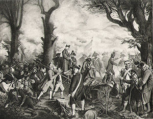
Battle of Grauholz
Battle between the First French Republic and the Canton of Bern
Distance: Approx. 1271 meters
Latitude and longitude: 47.01666667,7.5
The Battle of Grauholz on 5 March 1798 was a battle between a Bernese army under Karl Ludwig von Erlach against the French Revolutionary Army under Balthazar Alexis Henri Schauenburg. The battle took place at Grauholz, a wooded hill in what is now the municipalities of Urtenen-Schönbühl and Moosseedorf in the canton of Bern in Switzerland. The government of Bern had already surrendered the previous day, and the Bernese defeat at Grauholz ended their resistance to the French in the north of the canton.

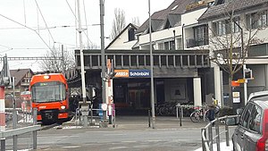
Schönbühl SBB railway station
Railway station in Urtenen-Schönbühl, Switzerland
Distance: Approx. 1215 meters
Latitude and longitude: 47.01893,7.49892889
Schönbühl SBB railway station (‹See Tfd›German: Bahnhof Schönbühl SBB) is a railway station in the municipality of Urtenen-Schönbühl, in the Swiss canton of Bern. It is an intermediate stop on the standard gauge Olten–Bern line of Swiss Federal Railways. The station is approximately 290 metres (950 ft) south of Schönbühl RBS on the 1,000 mm (3 ft 3+3⁄8 in) gauge Solothurn–Worblaufen line of Regionalverkehr Bern-Solothurn.
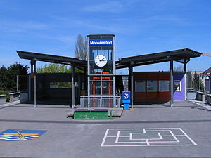
Moosseedorf railway station
Railway station in Moosseedorf, Switzerland
Distance: Approx. 147 meters
Latitude and longitude: 47.01611111,7.485
Moosseedorf railway station (‹See Tfd›German: Bahnhof Moosseedorf) is a railway station in the municipality of Moosseedorf, in the Swiss canton of Bern. It is an intermediate stop on the 1,000 mm (3 ft 3+3⁄8 in) gauge Solothurn–Worblaufen line of Regionalverkehr Bern-Solothurn.

Schönbühl Shoppyland railway station
Railway station in Urtenen-Schönbühl, Switzerland
Distance: Approx. 843 meters
Latitude and longitude: 47.01888889,7.49388889
Schönbühl Shoppyland railway station (‹See Tfd›German: Bahnhof Schönbühl Shoppyland) is a railway station in the municipality of Moosseedorf, in the Swiss canton of Bern. It is an intermediate stop on the 1,000 mm (3 ft 3+3⁄8 in) gauge Solothurn–Worblaufen line of Regionalverkehr Bern-Solothurn. The station serves the Shoppyland Schönbühl shopping center.
Schönbühl RBS railway station
Railway station in Urtenen-Schönbühl, Switzerland
Distance: Approx. 843 meters
Latitude and longitude: 47.01888889,7.49388889
Schönbühl RBS railway station (‹See Tfd›German: Bahnhof Schönbühl RBS) is a railway station in the municipality of Urtenen-Schönbühl, in the Swiss canton of Bern. It is an intermediate stop on the 1,000 mm (3 ft 3+3⁄8 in) gauge Solothurn–Worblaufen line of Regionalverkehr Bern-Solothurn. The station is approximately 290 metres (950 ft) north of Schönbühl SBB on the standard gauge Olten–Bern line of Swiss Federal Railways.

Urtenen railway station
Railway station in Urtenen-Schönbühl, Switzerland
Distance: Approx. 1917 meters
Latitude and longitude: 47.02888889,7.50111111
Urtenen railway station (‹See Tfd›German: Bahnhof Urtenen) is a railway station in the municipality of Urtenen-Schönbühl, in the Swiss canton of Bern. It is an intermediate stop on the 1,000 mm (3 ft 3+3⁄8 in) gauge Solothurn–Worblaufen line of Regionalverkehr Bern-Solothurn.
Weather in this IP's area
broken clouds
8 Celsius
8 Celsius
7 Celsius
9 Celsius
1018 hPa
90 %
1018 hPa
955 hPa
10000 meters
1.54 m/s
320 degree
75 %
07:34:26
19:02:07