193.132.125.111 - IP Lookup: Free IP Address Lookup, Postal Code Lookup, IP Location Lookup, IP ASN, Public IP
Country:
Region:
City:
Location:
Time Zone:
Postal Code:
IP information under different IP Channel
ip-api
Country
Region
City
ASN
Time Zone
ISP
Blacklist
Proxy
Latitude
Longitude
Postal
Route
Luminati
Country
Region
eng
City
windsor
ASN
Time Zone
Europe/London
ISP
UUNET
Latitude
Longitude
Postal
IPinfo
Country
Region
City
ASN
Time Zone
ISP
Blacklist
Proxy
Latitude
Longitude
Postal
Route
IP2Location
193.132.125.111Country
Region
england
City
kettering
Time Zone
Europe/London
ISP
Language
User-Agent
Latitude
Longitude
Postal
db-ip
Country
Region
City
ASN
Time Zone
ISP
Blacklist
Proxy
Latitude
Longitude
Postal
Route
ipdata
Country
Region
City
ASN
Time Zone
ISP
Blacklist
Proxy
Latitude
Longitude
Postal
Route
Popular places and events near this IP address

Kettering
Town and civil parish in Northamptonshire, England
Distance: Approx. 617 meters
Latitude and longitude: 52.39312,-0.72292
Kettering is a market and industrial town as well as a civil parish in the North Northamptonshire district, in the ceremonial county of Northamptonshire, England. It is 45 miles (72 km) west of Cambridge, 31 miles (50 km) southwest of Peterborough, 28 miles (45 km) southeast of Leicester and 15 miles (24 km) north-east of Northampton. It is west of the River Ise, a tributary of the River Nene.

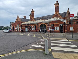
Kettering railway station
Railway station in Northamptonshire, England
Distance: Approx. 738 meters
Latitude and longitude: 52.39307,-0.73215
Kettering railway station serves the market and industrial town of Kettering in Northamptonshire, England. It lies south-west of the town centre, on the Midland Main Line, 71 miles (115 km) north of London St. Pancras.
Town Ground, Kettering
Distance: Approx. 875 meters
Latitude and longitude: 52.3924043,-0.734024
The Town Ground in Kettering, England was used by Northamptonshire for 65 first-class cricket matches between 1923 and 1971.
North Northamptonshire
District in England
Distance: Approx. 237 meters
Latitude and longitude: 52.4,-0.728
North Northamptonshire is one of two local government districts in Northamptonshire, England. Its council is a unitary authority, being a district council which also performs the functions of a county council. It was created in 2021.
Kettering Science Academy
School in Northamptonshire, UK
Distance: Approx. 1240 meters
Latitude and longitude: 52.396448,-0.707724
Kettering Science Academy is a secondary and sixth form school in Kettering, Northamptonshire, England, teaching pupils from age 11 to 18. It is a member of the Brooke Weston Trust and moved into a new building in September 2012. As of September 2023 there are 1327 students enrolled throughout the main school and the sixth form.

Kettering General Hospital
Hospital in England
Distance: Approx. 1139 meters
Latitude and longitude: 52.402,-0.7414
Kettering General Hospital is an NHS district hospital in Kettering, Northamptonshire, England. Mainly serving the unitary authority area of North Northamptonshire, it is managed by the Kettering General Hospital NHS Foundation Trust.

Kettering Savoy
Distance: Approx. 519 meters
Latitude and longitude: 52.39833333,-0.71805556
The Kettering Savoy (previously, Coliseum Theatre; subsequently, Ohio Theatre; also known as The Savoy) was a theatre and cinema in Russell Street, Kettering, Northamptonshire, England.

St Peter and St Paul's Church, Kettering
Church in Northamptonshire, England
Distance: Approx. 184 meters
Latitude and longitude: 52.39684444,-0.72663333
St Peter and St Paul's Church is a Church of England parish church in Kettering, Northamptonshire. It is a Grade I listed building.

St Mary's Hospital, Kettering
Hospital in Northamptonshire, England
Distance: Approx. 537 meters
Latitude and longitude: 52.3942,-0.7218
St Mary's Hospital is a health facility on London Road in Kettering, Northamptonshire, England. It is managed by Northamptonshire Healthcare NHS Foundation Trust. It was opened in 1838.

Kettering Municipal Offices
Municipal building in Kettering, Northamptonshire, England
Distance: Approx. 281 meters
Latitude and longitude: 52.3959,-0.7263
The Municipal Offices is a municipal building in Bowling Green Road in Kettering, Northamptonshire, England. The building is used as an area office for North Northamptonshire Council.

Kettering Library, Northamptonshire
Public Library in Kettering, England
Distance: Approx. 264 meters
Latitude and longitude: 52.3963,-0.7275
Kettering Library is a public library in Kettering, England, situated in the centre of the town between Market Place and St Peter and St Paul's Church.

Corn Exchange, Kettering
Commercial building in Kettering, Northamptonshire, England
Distance: Approx. 148 meters
Latitude and longitude: 52.3975,-0.7273
The Corn Exchange is a commercial building in the Market Place, Kettering, Northamptonshire, England. The structure, which was used as a cinema for much of the 20th century, currently accommodates a restaurant.
Weather in this IP's area
light rain
4 Celsius
-0 Celsius
3 Celsius
5 Celsius
1002 hPa
87 %
1002 hPa
990 hPa
10000 meters
5.81 m/s
12.96 m/s
268 degree
76 %
