193.132.112.80 - IP Lookup: Free IP Address Lookup, Postal Code Lookup, IP Location Lookup, IP ASN, Public IP
Country:
Region:
City:
Location:
Time Zone:
Postal Code:
ISP:
ASN:
language:
User-Agent:
Proxy IP:
Blacklist:
IP information under different IP Channel
ip-api
Country
Region
City
ASN
Time Zone
ISP
Blacklist
Proxy
Latitude
Longitude
Postal
Route
db-ip
Country
Region
City
ASN
Time Zone
ISP
Blacklist
Proxy
Latitude
Longitude
Postal
Route
IPinfo
Country
Region
City
ASN
Time Zone
ISP
Blacklist
Proxy
Latitude
Longitude
Postal
Route
IP2Location
193.132.112.80Country
Region
england
City
ilfracombe
Time Zone
Europe/London
ISP
Language
User-Agent
Latitude
Longitude
Postal
ipdata
Country
Region
City
ASN
Time Zone
ISP
Blacklist
Proxy
Latitude
Longitude
Postal
Route
Popular places and events near this IP address

Ilfracombe
Town in Devon, England
Distance: Approx. 482 meters
Latitude and longitude: 51.208,-4.12
Ilfracombe ( IL-frə-koom) is a seaside resort and civil parish on the North Devon coast, England, with a small harbour surrounded by cliffs. The parish stretches along the coast from the 'Coastguard Cottages' in Hele Bay toward the east and 4 miles (6 km) along the Torrs to Lee Bay toward the west. The resort is hilly and the highest point within the parish boundary is 'Hore Down Gate', 2 miles (3 km) inland and 860 feet (270 m) above sea level.

The Ilfracombe Academy
Academy in Ilfracombe, Devon, England
Distance: Approx. 521 meters
Latitude and longitude: 51.20466,-4.11435
The Ilfracombe Academy is a coeducational secondary school and sixth form with academy status, located in the North Devon town of Ilfracombe, England. Originally opened by then Education Secretary Margaret Thatcher in 1970 and known as Ilfracombe School & Community College, it was the first purpose-built comprehensive school in the country. Subsequently, it was called Ilfracombe College.
Ilfracombe Town A.F.C.
Association football club in England
Distance: Approx. 771 meters
Latitude and longitude: 51.20250833,-4.11556667
Ilfracombe Town Association Football Club is a football club based in Ilfracombe, Devon, England. They are currently members of the Western League Premier Division and play at Marlborough Park, situated high on a hill overlooking the Bristol Channel.

Hillsborough, Devon
Nature reserve in Devon, England
Distance: Approx. 726 meters
Latitude and longitude: 51.209,-4.103
Hillsborough is a local nature reserve in Ilfracombe, North Devon. It is known locally as the sleeping elephant. It was bought by the local council in the late nineteenth century to prevent development on the site.

Chambercombe
Suburb of Ilfracombe, North Devon, England
Distance: Approx. 317 meters
Latitude and longitude: 51.20666667,-4.11166667
Chambercombe is a hilly suburb in the North Devon town of Ilfracombe.

Landmark Theatre, Devon
Theatre in Devon, England
Distance: Approx. 672 meters
Latitude and longitude: 51.2104,-4.12287
The Landmark Theatre is a theatre in the North Devon coastal town of Ilfracombe. It has a distinctive double-conical design. It was built to replace The Pavilion Theatre, a Victorian building partly destroyed in a fire during the 1980s and later demolished.

Rapparee Cove
Distance: Approx. 356 meters
Latitude and longitude: 51.2102,-4.1085
Rapparee is a cove in the North Devon town of Ilfracombe. The cove is the site of the shipwreck of the transport London, which sank on 9 October 1796 in stormy weather. The ship's cargo reportedly contained gold and several African slaves who perished.

Ilfracombe Lifeboat Station
Lifeboat station in Devon, England
Distance: Approx. 210 meters
Latitude and longitude: 51.21,-4.1162
Ilfracombe Lifeboat Station is the base for Royal National Lifeboat Institution (RNLI) search and rescue operations at Ilfracombe, Devon, England. The first lifeboat was stationed in the town in 1828 and the present station was opened in 1996. For 29 years a second boat was operated from Morte Bay at Woolacombe.

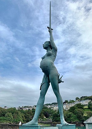
Verity (statue)
Sculpture by Damien Hirst
Distance: Approx. 217 meters
Latitude and longitude: 51.21088,-4.11158
Verity is a 2012 stainless steel and bronze statue created by Damien Hirst. The 20.25-metre (66.4 ft) tall sculpture stands on the pier at the entrance to the harbour in Ilfracombe, Devon, looking out over the Bristol Channel towards South Wales. It has been loaned to the town for 20 years.

Ilfracombe Cemetery
Cemetery in Devon, England
Distance: Approx. 935 meters
Latitude and longitude: 51.2013,-4.1175
Ilfracombe Cemetery (properly the Marlborough Road Cemetery) is the burial ground for the town of Ilfracombe in Devon in the United Kingdom. The cemetery is owned and maintained by North Devon Council. Located on the town's Marlborough Road, the cemetery is 8.88 acres in size and came into operation in 1926, with the first burial taking place on 22 April 1926.

Old Town Hall, Ilfracombe
Municipal building in Devon, England
Distance: Approx. 624 meters
Latitude and longitude: 51.2087,-4.1223
The Old Town Hall is a former municipal building in the High Street in Ilfracombe, Devon, England. The structure, which currently operates as gym, is a Grade II listed building.

Tunnels Beaches
Coves in Ilfracombe, Devon
Distance: Approx. 892 meters
Latitude and longitude: 51.211,-4.1259
The Tunnels Beaches are a set of coves in Ilfracombe, Devon, reachable from land only through tunnels cut through the rock. They are a local tourist attraction. The tunnels were excavated by the Ilfracombe Sea Bathing Company in the 1820s.
Weather in this IP's area
clear sky
4 Celsius
1 Celsius
4 Celsius
4 Celsius
1030 hPa
83 %
1030 hPa
1026 hPa
10000 meters
2.94 m/s
3.24 m/s
166 degree