Country:
 Great Britain
Region:
City:
Latitude and Longitude:
Time Zone:
Postal Code:
IP information under different IP Channel
ip-api
Country
Region
City
ASN
Time Zone
ISP
Blacklist
Proxy
Latitude
Longitude
Postal
Route
IPinfo
Country
Region
City
ASN
Time Zone
ISP
Blacklist
Proxy
Latitude
Longitude
Postal
Route
MaxMind
Country
Region
City
ASN
Time Zone
ISP
Blacklist
Proxy
Latitude
Longitude
Postal
Route
Luminati
Country
GBASN
Time Zone
Europe/London
ISP
UUNET
Latitude
Longitude
Postal
db-ip
Country
Region
City
ASN
Time Zone
ISP
Blacklist
Proxy
Latitude
Longitude
Postal
Route
ipdata
Country
Region
City
ASN
Time Zone
ISP
Blacklist
Proxy
Latitude
Longitude
Postal
Route
Popular places and events near this IP address
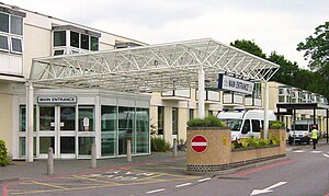
Frimley Park Hospital
Hospital in Surrey, England
Distance: Approx. 1381 meters
Latitude and longitude: 51.3196,-0.7441
Frimley Park Hospital is a large general hospital in Frimley, Surrey. It is managed by Frimley Health NHS Foundation Trust, and houses a private wing.

Blackwater railway station
Railway station in Hampshire, England
Distance: Approx. 1293 meters
Latitude and longitude: 51.332,-0.777
Blackwater railway station is a railway station in Blackwater, a town on the borders of Hampshire, Surrey and Berkshire in England. The station is managed by Great Western Railway, who provide services on the North Downs Line from Reading to Redhill and Gatwick Airport. Blackwater station has two platforms: platform 1 for services towards Gatwick Airport and platform 2 for services towards Reading.
Camberley Town F.C.
Association football club in England
Distance: Approx. 291 meters
Latitude and longitude: 51.32666667,-0.7575
Camberley Town Football Club is a semi-professional football based in Camberley, Surrey, England. They are currently members of the Combined Counties League Premier Division South and play at Krooner Park.

Blackwater, Hampshire
Town in Hampshire, England
Distance: Approx. 937 meters
Latitude and longitude: 51.328182,-0.774248
Blackwater is a town in the Hart District of Hampshire, England. It forms part of the Farnborough/Aldershot Built-up Area and almost is contiguous with Camberley. Blackwater is 32 miles (51 km) from London.
Hawley, Hampshire
Village and parish in Hampshire, England
Distance: Approx. 1072 meters
Latitude and longitude: 51.317,-0.768
Hawley is a small village in the civil parish of Blackwater and Hawley, in the Hart district of northeastern Hampshire, England. The village is contiguous with the small town of Blackwater. It is on the western edge of the Blackwater Valley conurbation, about 3 miles (5 km) northwest of central Farnborough, Hampshire, about 2 miles (3 km) west of Camberley, Surrey and about 33 miles (53 km) west-southwest of London.
Fernhill School, Farnborough
Community school in Farnborough, Hampshire, England
Distance: Approx. 1285 meters
Latitude and longitude: 51.3153,-0.7694
Fernhill School is a coeducational secondary school located in Farnborough in the English county of Hampshire. It is a community school administered by Hampshire County Council. The school previously held specialist status as a Language College and was known as Fernhill School & Language College.

Royal Military Academy Ground
Cricket ground
Distance: Approx. 1403 meters
Latitude and longitude: 51.33776,-0.76722
Royal Military Academy Ground is a cricket ground in Sandhurst, Berkshire near Camberley, Surrey. The ground itself is located within the grounds of the Royal Military Academy at Sandhurst. The first recorded match on the ground was in 1893, when Royal Military Academy Sandhurst played Dr Nicholson's XI. In use constantly since 1893, it hosted its only first-class match in 1938, when the British Army played Oxford University.
Bagshot F.C.
Association football club in England
Distance: Approx. 291 meters
Latitude and longitude: 51.32666667,-0.7575
Bagshot Football Club is a football club based in Bagshot, near Camberley in Surrey, England. They are currently members of the Surrey Premier League and play at Camberley Town's Krooner Park.
Watchmoor
Human settlement in England
Distance: Approx. 171 meters
Latitude and longitude: 51.3244,-0.7627
Watchmoor is an area in Camberley, Surrey, England, off the A331 Blackwater Valley Road. It is located opposite the Blackwater Valley Path. It is split into two parts: Watchmoor Park business park and Watchmoor Point industrial estate are accessed via Riverside Way, whilst the Sainsbury's Watchmoor Park Superstore and the Watchmoor Reserve nature area are accessed via a completely separate road mainly hidden from public view by trees, shrubs and hedges.

Wish Stream
River in Berkshire and Surrey, England
Distance: Approx. 1240 meters
Latitude and longitude: 51.33222222,-0.77583333
Wish Stream is a small, steep English river, which is a tributary of the River Blackwater. The border between the counties of Berkshire and Surrey follows the course in the Camberley area. The stream rises on heath land to the north of Camberley and descends in a south-westerly direction, passing through the grounds of the Royal Military Academy Sandhurst.
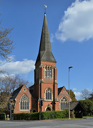
The Prospect Trust
Distance: Approx. 1381 meters
Latitude and longitude: 51.3165943,-0.7479001
The Prospect Trust is a multi-academy trust of 3 primary, secondary and sixth form academies in and around Surrey and Hampshire. Formed in 2017, they are currently educating 4,860 students.

The Concrete Elephant
Sculpture by Barbara Jones
Distance: Approx. 1057 meters
Latitude and longitude: 51.33305,-0.77101
The Concrete Elephant is a sculpture and local landmark standing along the A30 in Camberley on approach to The Meadows roundabout. It was created by Barbara Jones for Trollope & Colls for the Lord Mayor's Show held on the 19 November 1963, carried on a yellow low loader with a pink and grey cab behind a person dressed as a zebra carrying a zebra crossing pole and light and a red post office telephone box. It was to represent their pioneering use of reinforced concrete in pipework.
Weather in this IP's area
moderate rain
13 Celsius
12 Celsius
12 Celsius
13 Celsius
993 hPa
95 %
993 hPa
986 hPa
9000 meters
4.12 m/s
190 degree
40 %
07:15:23
18:25:19