193.131.125.192 - IP Lookup: Free IP Address Lookup, Postal Code Lookup, IP Location Lookup, IP ASN, Public IP
Country:
Region:
City:
Location:
Time Zone:
Postal Code:
IP information under different IP Channel
ip-api
Country
Region
City
ASN
Time Zone
ISP
Blacklist
Proxy
Latitude
Longitude
Postal
Route
Luminati
Country
ASN
Time Zone
Europe/London
ISP
UUNET
Latitude
Longitude
Postal
IPinfo
Country
Region
City
ASN
Time Zone
ISP
Blacklist
Proxy
Latitude
Longitude
Postal
Route
IP2Location
193.131.125.192Country
Region
england
City
stevenage
Time Zone
Europe/London
ISP
Language
User-Agent
Latitude
Longitude
Postal
db-ip
Country
Region
City
ASN
Time Zone
ISP
Blacklist
Proxy
Latitude
Longitude
Postal
Route
ipdata
Country
Region
City
ASN
Time Zone
ISP
Blacklist
Proxy
Latitude
Longitude
Postal
Route
Popular places and events near this IP address

Stevenage
Town and borough in Hertfordshire, England
Distance: Approx. 75 meters
Latitude and longitude: 51.90166667,-0.20194444
Stevenage ( STEE-vən-ij) is a town and borough in Hertfordshire, England, about 27 miles (43 km) north of London. Stevenage is east of junctions 7 and 8 of the A1(M), between Letchworth Garden City to the north and Welwyn Garden City to the south. In 1946, Stevenage was designated the United Kingdom's first New Town under the New Towns Act.

Six Hills
Collection of Roman barrows in Stevenage, Hertfordshire, England
Distance: Approx. 475 meters
Latitude and longitude: 51.897945,-0.203033
The Six Hills are a collection of Roman barrows situated alongside the old Great North Road on Six Hills Common in Stevenage, Hertfordshire, England. They are classed as a Scheduled Ancient Monument and are protected by law. They form the largest surviving Roman barrow group in England.

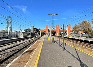
Stevenage railway station
Railway station in Hertfordshire, England
Distance: Approx. 303 meters
Latitude and longitude: 51.902,-0.207
Stevenage railway station serves the town of Stevenage in Hertfordshire, England. The station is around 27.6 miles (44.4 km) north of London King's Cross on the East Coast Main Line. The station lies just to the north of Langley junction, a grade separated junction where the Hertford Loop Line diverges from the East Coast Main Line; the two lines re-converge at Alexandra Palace in London's northern suburbs.

North Hertfordshire College
College of further education school in Stevenage, Hitchin, Hertfordshire, England
Distance: Approx. 606 meters
Latitude and longitude: 51.897,-0.2
North Hertfordshire College ("NHC") is a further education and higher education college operating in Stevenage, Hitchin, and Letchworth Garden City. NHC was established on 1 April 1991, through the amalgamation of Stevenage College, Hitchin College and Letchworth Technical College. NHC is graded 'Good with Outstanding features' by Ofsted.

Stevenage Borough Council
Distance: Approx. 246 meters
Latitude and longitude: 51.9,-0.203
Stevenage Borough Council is the local authority for Stevenage, a local government district with borough status in Hertfordshire, England. The council has been under Labour majority control since 1974. It is based at Daneshill House on Danestrete.

Barclay Academy
Academy in Stevenage, Hertfordshire, England
Distance: Approx. 1373 meters
Latitude and longitude: 51.914537,-0.202582
Barclay Academy is a secondary school and sixth form located in Stevenage, Hertfordshire, England. The current head teacher is Dr. Matthew Laban.
Women's Engineering Society
Women's engineering organisation
Distance: Approx. 683 meters
Latitude and longitude: 51.896062,-0.202365
The Women's Engineering Society is a United Kingdom professional learned society and networking body for women engineers, scientists and technologists. It was the first professional body set up for women working in all areas of engineering, predating the Society of Women Engineers by around 30 years.

Ditchmore Lane
Distance: Approx. 503 meters
Latitude and longitude: 51.9064,-0.20531667
Ditchmore Lane is a cricket ground in Stevenage, Hertfordshire, England. The first recorded match on the ground was in 1921, when Hertfordshire played their first Minor Counties Championship match which was against Buckinghamshire. From 1921 to 2000, the ground played host to 41 Minor Counties Championship matches and 2 MCCA Knockout Trophy matches.
Stevenage Mail Centre
Distance: Approx. 691 meters
Latitude and longitude: 51.896,-0.2031
Stevenage mail centre was a Royal Mail mail centre in Stevenage, Hertfordshire, England. In 2010, Royal Mail announced that a number of sorting offices from around the Home counties, including the Stevenage, Hitchin, Berkhamsted and Welwyn Garden City would be closed and merged into a large mail processing centre in Hemel Hempstead. These closures initiated a protest by the workers at the Stevenage mail centre, and members of the CWU in November 2010 It underwent partial closure in 2012, though it remains an active Royal Mail facility as of 2017.

List of local nature reserves in Hertfordshire
Distance: Approx. 303 meters
Latitude and longitude: 51.9,-0.2
Hertfordshire is a county in eastern England. It is bordered by Bedfordshire to the north, Cambridgeshire to the north-east, Essex to the east, Buckinghamshire to the west and Greater London to the south. The county town is Hertford.

Stevenage Clock Tower
Historic site
Distance: Approx. 90 meters
Latitude and longitude: 51.90169,-0.20159
Stevenage Clock Tower is a Grade II listed structure in Town Square in the centre of Stevenage New Town. A panel on the tower records the visit of Elizabeth II in 1959. The queen unveiled it as part of the ceremony to open the first phase of the town centre.

Stevenage Bus Interchange
Stevenage Bus Station, operations and history
Distance: Approx. 303 meters
Latitude and longitude: 51.9,-0.2
Stevenage Bus Interchange is a facility that serves the town of Stevenage, Hertfordshire, with local and regional bus services. These include services to Watford, Cheshunt, and Hertford, within Hertfordshire, Luton, Bedfordshire, Cambridge, Cambridgeshire and Victoria Coach Station, London. There are National Rail connections through Stevenage Railway Station on the other side of Lytton Way.
Weather in this IP's area
light rain
6 Celsius
1 Celsius
5 Celsius
7 Celsius
1003 hPa
81 %
1003 hPa
991 hPa
10000 meters
9.26 m/s
250 degree
75 %