193.131.112.208 - IP Lookup: Free IP Address Lookup, Postal Code Lookup, IP Location Lookup, IP ASN, Public IP
Country:
Region:
City:
Location:
Time Zone:
Postal Code:
ISP:
ASN:
language:
User-Agent:
Proxy IP:
Blacklist:
IP information under different IP Channel
ip-api
Country
Region
City
ASN
Time Zone
ISP
Blacklist
Proxy
Latitude
Longitude
Postal
Route
db-ip
Country
Region
City
ASN
Time Zone
ISP
Blacklist
Proxy
Latitude
Longitude
Postal
Route
IPinfo
Country
Region
City
ASN
Time Zone
ISP
Blacklist
Proxy
Latitude
Longitude
Postal
Route
IP2Location
193.131.112.208Country
Region
england
City
ruislip
Time Zone
Europe/London
ISP
Language
User-Agent
Latitude
Longitude
Postal
ipdata
Country
Region
City
ASN
Time Zone
ISP
Blacklist
Proxy
Latitude
Longitude
Postal
Route
Popular places and events near this IP address

Ruislip
Area of west London, England
Distance: Approx. 724 meters
Latitude and longitude: 51.576,-0.433
Ruislip ( RY-slip) is a suburb in the London Borough of Hillingdon in West London. Prior to 1965 it was in Middlesex. Ruislip lies 13.8 miles (22.2 km) west-north-west of Charing Cross, London.

Ruislip tube station
London Underground station
Distance: Approx. 274 meters
Latitude and longitude: 51.57138889,-0.42111111
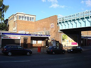
Ruislip is a London Underground station in Ruislip in west London. The station is on the Uxbridge branch of both the Metropolitan and Piccadilly lines, between Ickenham and Ruislip Manor stations. The station is located on Station Approach.
Wealdstone F.C.
Association football club in London, England
Distance: Approx. 641 meters
Latitude and longitude: 51.56944444,-0.41666667
Wealdstone Football Club ( WEELD-stone) is an English semi-professional football club based in Ruislip, London Borough of Hillingdon, and affiliated to the Middlesex County Football Association. They currently play in the National League, the fifth level of the English football league system. Their traditional colours are royal blue and white, and they are nicknamed "The Stones" or "The Royals".
West Ruislip station
London Underground and railway station
Distance: Approx. 1051 meters
Latitude and longitude: 51.5696,-0.4373
West Ruislip is a station on Ickenham High Road on the borders of Ickenham and western Ruislip in the London Borough of Hillingdon in Greater London, England, formerly in the county of Middlesex. It is served by London Underground (LU) and National Rail trains on different platforms. It is the western terminus of the London Underground Central line's West Ruislip branch; Ruislip Gardens is the next station towards central London.

Ruislip Manor tube station
London Underground station
Distance: Approx. 754 meters
Latitude and longitude: 51.57333333,-0.4125
Ruislip Manor is a London Underground station in Ruislip Manor in west London. The station is on the Uxbridge branch of both the Metropolitan and Piccadilly lines, between Ruislip and Eastcote stations. The station is located on Victoria Road, where the line crosses on a bridge: there are two curved entrances, with access to the platforms being by stairways.
RAF Blenheim Crescent
Distance: Approx. 832 meters
Latitude and longitude: 51.56944444,-0.43361111
Royal Air Force Blenheim Crescent or more RAF Blenheim Crescent is a non-flying Royal Air Force station, in Ruislip, in Greater London, England, presently used by the United States military for administration.
Ruislip Priory
Distance: Approx. 659 meters
Latitude and longitude: 51.5787964,-0.4273295
Ruislip Priory was a priory in Middlesex, England. In 1086 or 1087 the manor of Ruislip was given to Bec Abbey by Ernulf de Hesdin. An administrative centre, it had a priory before 1200.

Manor Farm, Ruislip
Historic site in Greater London, England
Distance: Approx. 639 meters
Latitude and longitude: 51.578206,-0.428451
Manor Farm is a 22-acre (8.9 ha) historic site in Ruislip, Greater London. It incorporates a medieval farm complex, with a main old barn dating from the 13th century and a farm house from the 16th. Nearby are the remains of a motte-and-bailey castle believed to date from shortly after the Norman conquest of England.

St Martin's Church, Ruislip
Church in United Kingdom
Distance: Approx. 409 meters
Latitude and longitude: 51.57666667,-0.42611111
St Martin's Church is a church in the west London town of Ruislip, within the London Borough of Hillingdon. It has been designated since January 1950 by English Heritage as a Grade I listed building. The present chancel and nave date back to the 13th century.

Ruislip Depot
Distance: Approx. 1052 meters
Latitude and longitude: 51.564,-0.425
Ruislip depot is a London Underground traction maintenance depot on the Central line, and is situated between the stations of Ruislip Gardens and West Ruislip in the London Borough of Hillingdon. The depot is accessible from both ends, and was built for the Central Line extensions under the 1935-1940 New Works Programme. It was nearly completed by 1939, when the outbreak of the Second World War prevented further work.

The Swan Inn, Ruislip
Former pub in Ruislip, London
Distance: Approx. 432 meters
Latitude and longitude: 51.576547,-0.427058
The Swan Inn is a Grade II listed former public house on the High Street (dating back to the 16th century in Ruislip, Middlesex. It then became a branch of the Café Rouge restaurant chain but this closed at the end of 2022. It has recently been bought by a new deveoper and something new should open there by the end of 2023.

Grosvenor Vale
Football stadium in Ruislip, London, England
Distance: Approx. 648 meters
Latitude and longitude: 51.5694,-0.4166
Grosvenor Vale (also simply known as The Vale) is a football ground in Ruislip, West London, England. It is the home ground of Wealdstone F.C. and Watford FC Women. The current capacity of the ground is 4,085.
Weather in this IP's area
clear sky
1 Celsius
-0 Celsius
1 Celsius
1 Celsius
1033 hPa
94 %
1033 hPa
1026 hPa
10000 meters
1.54 m/s
2.27 m/s
195 degree

