Country:
 USA
USARegion:
City:
Latitude and Longitude:
Time Zone:
Postal Code:
IP information under different IP Channel
ip-api
Country
Region
City
ASN
Time Zone
ISP
Blacklist
Proxy
Latitude
Longitude
Postal
Route
IPinfo
Country
Region
City
ASN
Time Zone
ISP
Blacklist
Proxy
Latitude
Longitude
Postal
Route
MaxMind
Country
Region
City
ASN
Time Zone
ISP
Blacklist
Proxy
Latitude
Longitude
Postal
Route
Luminati
Country
 DE
DERegion
he
City
frankfurtammain
ASN
Time Zone
Europe/Berlin
ISP
Tube-Hosting
Latitude
Longitude
Postal
db-ip
Country
Region
City
ASN
Time Zone
ISP
Blacklist
Proxy
Latitude
Longitude
Postal
Route
ipdata
Country
Region
City
ASN
Time Zone
ISP
Blacklist
Proxy
Latitude
Longitude
Postal
Route
Popular places and events near this IP address

Mission San José (California)
18th-century Spanish mission in California
Distance: Approx. 2078 meters
Latitude and longitude: 37.53277778,-121.91944444
Mission San José is a Spanish mission located in the present-day city of Fremont, California, United States. It was founded on June 11, 1797, by the Franciscan order and was the fourteenth Spanish mission established in California. The mission is the namesake of the Mission San José district of Fremont, which was an independent town subsumed into the city when it was incorporated in 1957.
NUMMI
Former American automaker based in Fremont, California
Distance: Approx. 3577 meters
Latitude and longitude: 37.49472222,-121.94472222
New United Motor Manufacturing, Inc. (NUMMI) was an American automobile manufacturing company in Fremont, California, jointly owned by General Motors and Toyota that opened in 1984 and closed in April 2010. The plant is located in the East Industrial area of Fremont next to the Mud Slough between Interstate 880 and Interstate 680, the plant's peak production year was 2006, when it manufactured 428,633 vehicles.
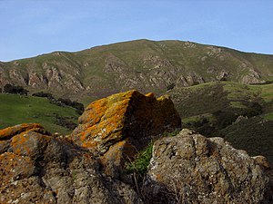
Mission Peak
Public park in California, United States
Distance: Approx. 2889 meters
Latitude and longitude: 37.5124365,-121.8805126
Mission Peak is a mountain peak located east of Fremont, California. It is the northern summit on a ridge that includes Mount Allison and Monument Peak. Mission Peak has symbolic importance, and is depicted on the logo of the City of Fremont.
Rancho Agua Caliente (Alameda County)
Mexican land grant in California
Distance: Approx. 600 meters
Latitude and longitude: 37.51,-121.91
Rancho Agua Caliente was a 9,564-acre (38.70 km2) Mexican land grant in present-day Alameda County, California granted in 1836 by Governor Nicolás Gutiérrez to Antonio Suñol and confirmed in 1839 by Governor Juan Alvarado to Fulgencio Higuera. The name means "warm water" and refers to the warm springs located in the foothills a short distance south of Mission San José. The grant is just south of present-day Fremont.
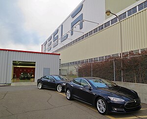
Tesla Fremont Factory
Tesla, Inc. factory
Distance: Approx. 3578 meters
Latitude and longitude: 37.49475556,-121.94476667
The Tesla Fremont Factory is an automobile manufacturing plant in Fremont, California, United States, operated by Tesla, Inc. The factory originally opened as General Motors' Fremont Assembly in 1962, and then was operated by New United Motor Manufacturing, Inc. (NUMMI), a joint venture of GM and Toyota from 1984.
Ohlone College
Community college in Fremont, California, US
Distance: Approx. 1754 meters
Latitude and longitude: 37.53052222,-121.91445833
Ohlone College (Ohlone or OC; ) is a public community college with its main campus in Fremont, California and a second campus in Newark. It is part of the California Community College System. The Ohlone Community College District serves the cities of Fremont and Newark, as well as parts of Union City.

Warm Springs/South Fremont station
Rapid transit station in San Francisco Bay Area
Distance: Approx. 2714 meters
Latitude and longitude: 37.503,-121.94
Warm Springs/South Fremont station is a Bay Area Rapid Transit (BART) station located in the Warm Springs district of Fremont, California. The station is served by the Orange and Green lines. It was the southern terminus of both lines from its opening on March 25, 2017 until June 13, 2020, when Milpitas and Berryessa/North San José stations opened as part of the Silicon Valley BART extension.

Leland Stanford Winery
Historic site in Fremont, California
Distance: Approx. 1270 meters
Latitude and longitude: 37.503411,-121.912311
Leland Stanford Winery was a winery located in the Santa Clara Valley AVA, in Fremont, California, United States. The winery was founded by Leland Stanford in 1869. The vineyard was planted by Stanford's brother, Josiah Stanford.

Oorja Fuel Cells
US fuel cell manufacturer
Distance: Approx. 2605 meters
Latitude and longitude: 37.4995,-121.93541667
Oorja Fuel Cells (Oorja Protonics Inc) is an energy company that designs, manufactures, and commercializes direct methanol fuel cells for use in the logistics, automotive, distributed generation (micro-grid), and telecommunication industries. Oorja develops direct methanol fuel cells ranging in power from 0.5 to 100 kilowatts.
Averroes High School
High school in California, United States
Distance: Approx. 2936 meters
Latitude and longitude: 37.5196,-121.9458
Averroes High School is a college preparatory Islamic high school (grades 9–12) in Fremont, California, founded in 2010. It is the first Islamic high school in the Bay Area.

Washington Township Museum of Local History (Fremont, California)
Historical museum located in Fremont, California
Distance: Approx. 1816 meters
Latitude and longitude: 37.53007,-121.92033
Washington Township Museum of Local History is a historical museum located in Fremont, California. The two historical organizations, the Mission Peak Heritage Foundation (MPHF) and Washington Township Historical Society (WTHS), formed the Museum of Local History Guild to focus on education, archival research and preservation of the historical resources of Washington Township. The Washington Township was created in 1853 from the southwestern part of Alameda County.

Laguna Creek watershed
River in California, United States
Distance: Approx. 1319 meters
Latitude and longitude: 37.52615121,-121.90883531
The Laguna Creek watershed consists of 25.1 square miles (100 km2) of land within northern California's Alameda County. The watershed drains the foothills of the Diablo Range south of Niles Canyon. To the southeast, the area of Mission Peak Regional Preserve around Mission Peak is included.
Weather in this IP's area
smoke
24 Celsius
24 Celsius
20 Celsius
28 Celsius
1014 hPa
58 %
1014 hPa
999 hPa
10000 meters
5.66 m/s
330 degree
75 %
07:10:36
18:38:34